Enable Location

We need your location to show you interesting places around you

Discover nearby places

Find interesting locations and hidden gems around you

Precise directions

Get accurate directions and distances to places

Your location is never shared with other users. It's only used when you tap the location button.

Log in to your account

Start exploring — it's free

Trusted by 61,489 travelers worldwide

Continue with Google
Continue with Apple
or

We will send you a code to connect

By continuing, you accept our Terms and Conditions and our Privacy Policy

Check your inbox

We've sent a pincode in your inbox. Please enter the code below.

Round Top

Round Top, Mountain summit in Contra Costa County, California, US

Description

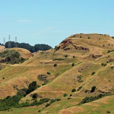
Round Top is a mountain summit in the Sierra Nevada of California featuring dark volcanic basalt rock formations and alpine meadows surrounding the peak. The upper sections display steep rocky terrain that defines the landscape and opens views across the surrounding terrain.

History

Geologist William Brewer explored the summit in 1863 and recorded detailed observations of the surrounding region in his field notes. His expedition accounts helped document the geological and geographical features of this high alpine area in the Sierra Nevada.

Culture

Native American tribes utilized the lands around Round Top for seasonal hunting and gathering before European settlers arrived in the region.

Practical

The climb is steep and demands scrambling skills for rocky sections near the top. Visitors should prepare for changing weather and wear sturdy footwear suitable for rough terrain.

Did you know?

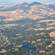
On clear days, the summit offers an exceptional view spanning from Mount Diablo to Lake Tahoe. This expansive perspective reveals multiple alpine passes and valleys that showcase the geological structure across the entire region.

Location
GPS coordinates
37.85015,-122.19261
Latest update
December 12, 2025 07:53

AroundUs brings together thousands of curated places, local tips, and hidden gems, enriched daily by 60,000 contributors worldwide. Discover all places nearby (California).

Around this place
People's Park
United States of America

People's Park

5.9 km
California Memorial Stadium
United States of America

California Memorial Stadium

5.6 km
Chabot Space and Science Center
United States of America

Chabot Space and Science Center

3.7 km
Hearst Greek Theatre
United States of America

Hearst Greek Theatre

6 km
Telegraph Avenue
United States of America

Telegraph Avenue

6.1 km
Bevatron
United States of America

Bevatron

6 km
Lawrence Hall of Science
United States of America

Lawrence Hall of Science

5.8 km
Thorsen House
United States of America

Thorsen House

5.6 km
Robert Sibley Volcanic Regional Preserve
United States of America

Robert Sibley Volcanic Regional Preserve

1.1 km
Housing at the University of California, Berkeley
United States of America

Housing at the University of California, Berkeley

5.8 km
Lafayette Reservoir
United States of America

Lafayette Reservoir

6.1 km
Dr. Aurelia Reinhardt Redwood Regional Park
United States of America

Dr. Aurelia Reinhardt Redwood Regional Park

4.7 km
University of California Botanical Garden
United States of America

University of California Botanical Garden

4.8 km
The Big "C"
United States of America

The Big "C"

5.7 km
LeConte Hall
United States of America

LeConte Hall

6.1 km
Gilman Hall
United States of America

Gilman Hall

6.1 km
Maynard Buehler House
United States of America

Maynard Buehler House

2.5 km
St. John's Presbyterian Church
United States of America

St. John's Presbyterian Church

5.4 km
Joaquin Miller House
United States of America

Joaquin Miller House

4.4 km
Julia Morgan Hall
United States of America

Julia Morgan Hall

5.9 km
Senior Hall
United States of America

Senior Hall

6 km
Leimert Bridge
United States of America

Leimert Bridge

4.6 km
Huckleberry Botanic Regional Preserve
United States of America

Huckleberry Botanic Regional Preserve

617 m
Moraga Adobe
United States of America

Moraga Adobe

3.6 km
Temescal Regional Recreation Area
United States of America

Temescal Regional Recreation Area

3.4 km
Kehilla Community Synagogue
United States of America

Kehilla Community Synagogue

5.6 km
The Chandler Building
United States of America

The Chandler Building

6.1 km
Charles W. Merrill House
United States of America

Charles W. Merrill House

5.3 km
Show the full map
« Round Top - Mountain summit in Contra Costa County, California, US » is provided by Around Us (aroundus.com). Images and texts are derived from Wikimedia project under a Creative Commons license. You are allowed to copy, distribute, and modify copies of this page, under the conditions set by the license, as long as this note is clearly visible.

Discover hidden gems everywhere you go!

From secret cafés to breathtaking viewpoints, skip the crowded tourist spots and find places that match your style. Our app makes it easy with voice search, smart filtering, route optimization, and insider tips from travelers worldwide. Download now for the complete mobile experience.

Around Us App Screenshot

A unique approach to discovering new places

Le Figaro

All the places worth exploring

France Info

A tailor-made excursion in just a few clicks

20 Minutes

Around Us
Travel Guide & Maps
Download

Send to your phone

QR Code
1

Open the camera app on your mobile.

2

Point at the QR code with your camera. A notification will appear.

3

Tap the notification to open the link.