Enable Location

We need your location to show you interesting places around you

Discover nearby places

Find interesting locations and hidden gems around you

Precise directions

Get accurate directions and distances to places

Your location is never shared with other users. It's only used when you tap the location button.

Camanche Reservoir

Log in to your account

Start exploring — it's free

Trusted by 61,998 travelers worldwide

Continue with Google
Continue with Apple
or

We will send you a code to connect

By continuing, you accept our Terms and Conditions and our Privacy Policy

Check your inbox

We've sent a pincode in your inbox. Please enter the code below.

Camanche Reservoir

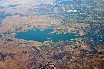
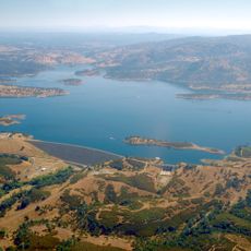
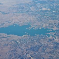
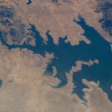
Camanche Reservoir, Water reservoir in the Sierra Foothills, California, US

Camanche Reservoir is a large water storage facility in the Sierra Foothills that sits at the boundary where three counties meet. The lake stretches across multiple ridges and valleys with extensive shoreline for recreation.

The dam was completed in 1963 and flooded the former gold rush settlement of Camanche along with other nearby towns. This project marked a major change in how water flowed through the region.

The reservoir is a gathering place for fishing and boating enthusiasts who spend their leisure time on the water and along its shores. Local communities have built their recreational traditions around the lake and its resources.

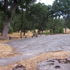
The area around the lake has many camping and parking options with basic amenities like showers and restrooms available. The best time to visit is outside the hottest summer months when the water is more enjoyable.

The lake receives regular deposits of fish between fall and early summer months to support populations for fishing. This restocking practice has become essential to maintaining the recreation opportunities that draw visitors.

The community of curious travelers

AroundUs brings together thousands of curated places, local tips, and hidden gems, enriched daily by 60,000 contributors worldwide.

Start exploring
Location
GPS coordinates
38.22361,-121.00000
Latest update
December 7, 2025 20:40
Around this place
Preston School of Industry
United States of America

Preston School of Industry

16.3 km
Indian Grinding Rock State Historic Park
United States of America

Indian Grinding Rock State Historic Park

38.4 km
New Hogan Lake
United States of America

New Hogan Lake

18.3 km
Cosumnes River Preserve
United States of America

Cosumnes River Preserve

38.7 km
Pardee Dam
United States of America

Pardee Dam

13.6 km
Micke Grove Zoo
United States of America

Micke Grove Zoo

28.7 km
Camanche Dam
United States of America

Camanche Dam

2 km
Knight Foundry
United States of America

Knight Foundry

26.7 km
Micke Grove Regional Park
United States of America

Micke Grove Regional Park

28.7 km
Salt Spring Valley Reservoir
United States of America

Salt Spring Valley Reservoir

30.2 km
Brewster Building
United States of America

Brewster Building

31.8 km
Brewster House
United States of America

Brewster House

26.8 km
Community Methodist Church of Ione
United States of America

Community Methodist Church of Ione

15.2 km
Thorn House
United States of America

Thorn House

28.3 km
Calaveras County Courthouse
United States of America

Calaveras County Courthouse

28.2 km
Alta Mesa Farm Bureau Hall
United States of America

Alta Mesa Farm Bureau Hall

26.6 km
Elks Building
United States of America

Elks Building

38.2 km
Woodbridge Masonic Lodge No. 131
United States of America

Woodbridge Masonic Lodge No. 131

27.4 km
D. Stewart Company Store
United States of America

D. Stewart Company Store

15.5 km
Harmony Grove Church
United States of America

Harmony Grove Church

17.6 km
Benjamin Holt House
United States of America

Benjamin Holt House

38.5 km
John J. Snyder House
United States of America

John J. Snyder House

27.7 km
Scully Ranch
United States of America

Scully Ranch

14.9 km
I.O.O.F. Hall
United States of America

I.O.O.F. Hall

27.3 km
William J. Paugh House
United States of America

William J. Paugh House

24.6 km
Locke's Meat Market
United States of America

Locke's Meat Market

14.7 km
Jackson Downtown Historic District
United States of America

Jackson Downtown Historic District

24.3 km
Chaparral Gardens
United States of America

Chaparral Gardens

37.4 km
Show the full map
« Camanche Reservoir - Water reservoir in the Sierra Foothills, California, US » is provided by Around Us (aroundus.com). Images and texts are derived from Wikimedia project under a Creative Commons license. You are allowed to copy, distribute, and modify copies of this page, under the conditions set by the license, as long as this note is clearly visible.

Discover hidden gems everywhere you go!

From secret cafés to breathtaking viewpoints, skip the crowded tourist spots and find places that match your style. Our app makes it easy with voice search, smart filtering, route optimization, and insider tips from travelers worldwide. Download now for the complete mobile experience.

Around Us App Screenshot

A unique approach to discovering new places

Le Figaro

All the places worth exploring

France Info

A tailor-made excursion in just a few clicks

20 Minutes

Around Us
Travel Guide & Maps
Download

Send to your phone

QR Code
1

Open the camera app on your mobile.

2

Point at the QR code with your camera. A notification will appear.

3

Tap the notification to open the link.