Coyote Creek Bridge

Log in to your account

AroundUs is a community-driven map of interesting places, built by curious explorers like you. It grows with every review, story, and photo you share.
Connect to save your favorite spots, contribute locations, and create personalized routes.
Continue with Google
Continue with Apple
Continue with X
Continue with Facebook
Continue with email
By continuing, you accept our Terms and Conditions and our Privacy Policy
Create an account
Add to collection
Map
Suggest a change
Share

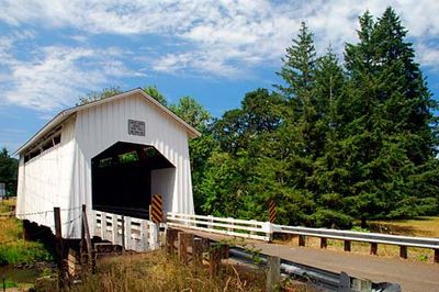
Coyote Creek Bridge, Covered bridge in Lane County, Oregon.

Coyote Creek Bridge is a covered bridge in Lane County that carries traffic across a small creek using a Howe truss structural system. The interior features rectangular portals and ribbon-style openings below the roof line that allow light to enter the covered passageway.

The bridge was built in 1922 near the West Side Old Territorial Road and served as part of the main travel route at that time. Later, a modern bypass was constructed, and it became a secondary local crossing.

The bridge displays construction methods from the early 20th century and serves as a record of how engineers at that time crossed waterways. It represents engineering practices that were common across rural America during that era.

The bridge is located on Battle Creek Road in Eugene and remains passable for standard vehicles. Drivers should be aware it is a single-lane crossing and watch for traffic approaching from the opposite direction.

Heavy snowfall damaged the roof in 1969, and the bridge remained uncovered for several months until repairs were finished. County crews completed the restoration work the following spring.

Location: Oregon

GPS coordinates: 43.97000,-123.31889

Latest update: December 14, 2025 18:12

Photos
Around this place
Cascades Raptor Center
United States of America

Cascades Raptor Center

19.2 km
Fern Ridge Reservoir
United States of America

Fern Ridge Reservoir

16.8 km
Hult Center for the Performing Arts
United States of America

Hult Center for the Performing Arts

20.3 km
Civic Stadium
United States of America

Civic Stadium

19.7 km
Eugene Public Library
United States of America

Eugene Public Library

20 km
King Estate Winery
United States of America

King Estate Winery

14.6 km
W.O.W. Hall
United States of America

W.O.W. Hall

20 km
St. Mary Roman Catholic Church
United States of America

St. Mary Roman Catholic Church

19.8 km
McDonald Theatre
United States of America

McDonald Theatre

20.1 km
Oregon Air and Space Museum
United States of America

Oregon Air and Space Museum

18.3 km
Fern Ridge Wildlife Area
United States of America

Fern Ridge Wildlife Area

16.8 km
Kalapuya High School
United States of America

Kalapuya High School

15.5 km
Wayne Morse Farm
United States of America

Wayne Morse Farm

18.6 km
Woodrow Wilson Junior High School
United States of America

Woodrow Wilson Junior High School

19.4 km
Frank L. and Ida H. Chambers House
United States of America

Frank L. and Ida H. Chambers House

18.7 km
A. V. Peters House
United States of America

A. V. Peters House

19.6 km
Untitled
United States of America

Untitled

20.3 km
Fred E. Chambers House
United States of America

Fred E. Chambers House

20 km
Christian–Patterson Rental Property
United States of America

Christian–Patterson Rental Property

20.1 km
Rice Apartments
United States of America

Rice Apartments

19.6 km
Daniel and Catherine Christian House
United States of America

Daniel and Catherine Christian House

20.3 km
Wallace and Glenn Potter House
United States of America

Wallace and Glenn Potter House

19.5 km
Abraham and Phoebe Ball House
United States of America

Abraham and Phoebe Ball House

19.7 km
Lane County Clerk's Building
United States of America

Lane County Clerk's Building

19.1 km
Charles C. Fitch Farmstead
United States of America

Charles C. Fitch Farmstead

7.3 km
Patterson–Stratton House
United States of America

Patterson–Stratton House

20.1 km
John Sutherland House
United States of America

John Sutherland House

8.6 km
Bijou Metro Cinema
United States of America

Bijou Metro Cinema

20.2 km
Show the full map
Reviews

Visited this place? Tap the stars to rate it and share your experience / photos with the community! Try now! You can cancel it anytime.

« Coyote Creek Bridge - Covered bridge in Lane County, Oregon » is provided by Around Us (aroundus.com). Images and texts are derived from Wikimedia project under a Creative Commons license. You are allowed to copy, distribute, and modify copies of this page, under the conditions set by the license, as long as this note is clearly visible.

Discover hidden gems everywhere you go!

From secret cafés to breathtaking viewpoints, skip the crowded tourist spots and find places that match your style. Our app makes it easy with voice search, smart filtering, route optimization, and insider tips from travelers worldwide. Download now for the complete mobile experience.

Around Us App Screenshot

A unique approach to discovering new places

Le Figaro

All the places worth exploring

France Info

A tailor-made excursion in just a few clicks

20 Minutes