Enable Location

We need your location to show you interesting places around you

Discover nearby places

Find interesting locations and hidden gems around you

Precise directions

Get accurate directions and distances to places

Your location is never shared with other users. It's only used when you tap the location button.

Erratic Rock State Natural Site

Log in to your account

Start exploring — it's free

Trusted by 62,477 travelers worldwide

Continue with Google
Continue with Apple
or

We will send you a code to connect

By continuing, you accept our Terms and Conditions and our Privacy Policy

Check your inbox

We've sent a pincode in your inbox. Please enter the code below.

Erratic Rock State Natural Site

Erratic Rock State Natural Site, Geological state park in Willamette Valley, Oregon, United States.

Erratic Rock State Natural Site is a geological park in Willamette Valley, Oregon, featuring a massive 40-ton rock sitting on a 250-foot hill surrounded by vineyards and farmland. From the top, visitors can see across to the Oregon Coast Range and the surrounding agricultural landscape.

The rock traveled over 500 miles from Canada during the Ice Age, between 12,000 and 17,000 years ago, carried by icebergs through Montana and Washington. This movement was part of the massive floods that reshaped the Pacific Northwest landscape.

The rock's name reflects how people understand this unusual formation in the landscape as a glacial erratic, a boulder found far from its source. Its presence among vineyards and farms makes it a point of local interest and curiosity for both visitors and residents of the region.

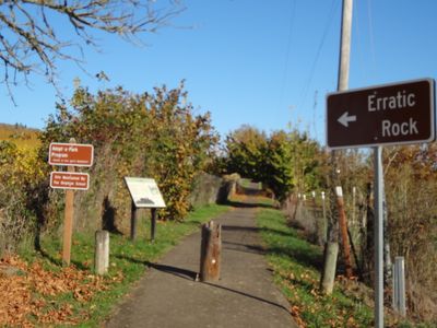
The rock is reached via a paved trail about 0.2 miles long starting from the parking area on SW Oldsville Road near Oregon Route 18. Access is straightforward and the walk takes only a few minutes for most visitors.

The rock is estimated to be around 600 million years old and originated from an ancient sea floor, making it one of the oldest objects at this site. It remains the largest erratic of its kind in Willamette Valley, demonstrating the tremendous power of glacial forces to move such massive material across such distances.

The community of curious travelers

AroundUs brings together thousands of curated places, local tips, and hidden gems, enriched daily by 60,000 contributors worldwide.

Start exploring
Location
GPS coordinates
45.14010,-123.29300
Latest update
December 9, 2025 18:43
Around this place
Evergreen Aviation & Space Museum
United States of America

Evergreen Aviation & Space Museum

13.7 km
Willamette Mission State Park
United States of America

Willamette Mission State Park

20.4 km
Our Lady of Guadalupe Trappist Abbey
United States of America

Our Lady of Guadalupe Trappist Abbey

22.5 km
Yamhill River lock and dam
United States of America

Yamhill River lock and dam

17.9 km
Evergreen Wings and Waves Waterpark
United States of America

Evergreen Wings and Waves Waterpark

13.3 km
Maud Williamson State Recreation Site
United States of America

Maud Williamson State Recreation Site

18.4 km
Dayton High School
United States of America

Dayton High School

18.4 km
Palmer House
United States of America

Palmer House

18.9 km
Hotel Oregon
United States of America

Hotel Oregon

11 km
Yamhill County Courthouse
United States of America

Yamhill County Courthouse

11.2 km
Pioneer Hall
United States of America

Pioneer Hall

10.1 km
John Phillips House
United States of America

John Phillips House

18.1 km
First Baptist Church
United States of America

First Baptist Church

19.3 km
Free Methodist Church
United States of America

Free Methodist Church

19 km
Sheridan Bridge
United States of America

Sheridan Bridge

9.3 km
Evangelical United Brethren Church
United States of America

Evangelical United Brethren Church

19.1 km
Evangelical Church of Lafayette
United States of America

Evangelical Church of Lafayette

18.5 km
Paul Londershausen House
United States of America

Paul Londershausen House

19.3 km
John T. Hash House
United States of America

John T. Hash House

19.1 km
McMinnville Downtown Historic District
United States of America

McMinnville Downtown Historic District

11 km
Baxter House
United States of America

Baxter House

19.1 km
Methodist Episcopal Parsonage
United States of America

Methodist Episcopal Parsonage

19.2 km
Dr. Stuart House
United States of America

Dr. Stuart House

19.6 km
Gottlieb Londershausen House
United States of America

Gottlieb Londershausen House

19.2 km
McMinnville Aquatic Center
United States of America

McMinnville Aquatic Center

10.7 km
Mack Theater
United States of America

Mack Theater

11 km
Spring Valley School
United States of America

Spring Valley School

18 km
San Salvador Beach
United States of America

San Salvador Beach

22.8 km
Show the full map
« Erratic Rock State Natural Site - Geological state park in Willamette Valley, Oregon, United States » is provided by Around Us (aroundus.com). Images and texts are derived from Wikimedia project under a Creative Commons license. You are allowed to copy, distribute, and modify copies of this page, under the conditions set by the license, as long as this note is clearly visible.

Discover hidden gems everywhere you go!

From secret cafés to breathtaking viewpoints, skip the crowded tourist spots and find places that match your style. Our app makes it easy with voice search, smart filtering, route optimization, and insider tips from travelers worldwide. Download now for the complete mobile experience.

Around Us App Screenshot

A unique approach to discovering new places

Le Figaro

All the places worth exploring

France Info

A tailor-made excursion in just a few clicks

20 Minutes

Around Us
Travel Guide & Maps
Download

Send to your phone

QR Code
1

Open the camera app on your mobile.

2

Point at the QR code with your camera. A notification will appear.

3

Tap the notification to open the link.