Portland Aerial Tram

Log in to your account

AroundUs is a community-driven map of interesting places, built by curious explorers like you. It grows with every review, story, and photo you share.
Connect to save your favorite spots, contribute locations, and create personalized routes.
By continuing, you accept our Terms and Conditions and our Privacy Policy
Add to collection
Map
Suggest a change
Share

Portland Aerial Tram, Urban aerial tram in Portland, United States

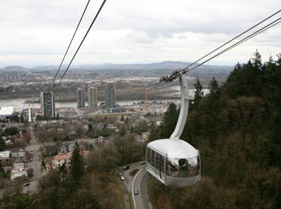
Portland Aerial Tram is an urban aerial tramway in Portland, United States, linking the South Waterfront neighborhood along the Willamette River to the health campus on Marquam Hill. The two cabins travel a distance of roughly 1000 meters (about 3300 feet) and carry up to 78 people each.

The installation came from a partnership between the city of Portland and the university, opening in December 2006 after years of planning. The investment aimed to improve access from the expanding riverfront district to the existing medical center.

The name reflects the link between healthcare and urban life that has become part of the city's identity since the opening. Commuters and visitors use the cabins daily to move between the riverfront and the hilltop hospital, reducing road traffic.

The system runs daily with schedules that change by season and offers reduced fares for certain user groups. The ride takes roughly three minutes in each direction and pairs well with a walk along the riverfront.

The cabins rise roughly 150 meters (about 500 feet) in elevation during the trip, so the view of the city and surrounding peaks changes continuously. On clear days, both Mount Hood and Mount St. Helens become visible through the windows.

Location: Portland

Official opening: December 15, 2006

Website: http://gobytram.com

GPS coordinates: 45.49930,-122.67300

Latest update: December 5, 2025 22:23

Parks and cultural sites in Portland

Portland contains cultural venues and green spaces. Powell's Books occupies a city block. Washington Park includes gardens and a zoo. The Japanese Garden and Chinese Garden present Asian landscaping styles. Parks define the city layout, including Mount Tabor on an extinct volcano. The Portland Art Museum holds Native American art collections. Multiple bridges span the Willamette River, connecting different districts.

Around this place
Show the full map
Tilikum Crossing, Bridge of the People
United States of America

Tilikum Crossing, Bridge of the People

779 m
USS Blueback
United States of America

USS Blueback

1.1 km
Oregon Museum of Science and Industry
United States of America

Oregon Museum of Science and Industry

1.2 km
Marquam Bridge
United States of America

Marquam Bridge

1 km
Spokane, Portland and Seattle Railway 700
United States of America

Spokane, Portland and Seattle Railway 700

1.3 km
Oregon Rail Heritage Center
United States of America

Oregon Rail Heritage Center

1.3 km
Ross Island Bridge
United States of America

Ross Island Bridge

659 m
Gibbs Street Pedestrian Bridge
United States of America

Gibbs Street Pedestrian Bridge

0 m
Lovejoy Fountain Park
United States of America

Lovejoy Fountain Park

1.2 km
Johan Poulsen House
United States of America

Johan Poulsen House

1 km
Mirabella Portland
United States of America

Mirabella Portland

308 m
John Ross Tower
United States of America

John Ross Tower

372 m
The Ardea
United States of America

The Ardea

445 m
Terwilliger Boulevard
United States of America

Terwilliger Boulevard

891 m
OHSU Center for Health & Healing
United States of America

OHSU Center for Health & Healing

166 m
Harrison West Condominium Tower
United States of America

Harrison West Condominium Tower

1.3 km
The Meriwether
United States of America

The Meriwether

381 m
Portland General Electric Company Station "L" Group
United States of America

Portland General Electric Company Station "L" Group

1.3 km
Caruthers Park
United States of America

Caruthers Park

281 m
Poet's Beach
United States of America

Poet's Beach

871 m
Jewish Shelter Home
United States of America

Jewish Shelter Home

686 m
Marquam Manor
United States of America

Marquam Manor

1.3 km
Trio
United States of America

Trio

1.2 km
Portland Spirit
United States of America

Portland Spirit

974 m
Holt–Saylor–Liberto House
United States of America

Holt–Saylor–Liberto House

474 m
Costanzo Family House
United States of America

Costanzo Family House

1.1 km
Milton W. Smith House
United States of America

Milton W. Smith House

156 m
Corkish Apartments
United States of America

Corkish Apartments

598 m
Show the full map

Reviews

Visited this place? Tap the stars to rate it and share your experience / photos with the community! Try now! You can cancel it anytime.

« Portland Aerial Tram - Urban aerial tram in Portland, United States » is provided by Around Us (aroundus.com). Images and texts are derived from Wikimedia project under a Creative Commons license. You are allowed to copy, distribute, and modify copies of this page, under the conditions set by the license, as long as this note is clearly visible.

Discover hidden gems everywhere you go!

From secret cafés to breathtaking viewpoints, skip the crowded tourist spots and find places that match your style. Our app makes it easy with voice search, smart filtering, route optimization, and insider tips from travelers worldwide. Download now for the complete mobile experience.

Around Us App Screenshot

A unique approach to discovering new places

Le Figaro

All the places worth exploring

France Info

A tailor-made excursion in just a few clicks

20 Minutes