Chest opened
+${chestReward.xp} XP
Explorer
NOUVEAU ×${chestReward.collectible.quantity}
tapez pour fermer
Chest locked

Open chests in the app

Around Us is built for your phone — chests unlock when you walk, explore and capture nearby places.

Enable Location

We need your location to show you interesting places around you

Discover nearby places

Find interesting locations and hidden gems around you

Precise directions

Get accurate directions and distances to places

Your location is never shared with other users. It's only used when you tap the location button.

Trojan Nuclear Power Plant

Log in to your account

Start exploring — it's free

Trusted by 72,991 travelers worldwide

Continue with Google
Continue with Apple
or

We will send you a code to connect

By continuing, you accept our Terms and Conditions and our Privacy Policy

Check your inbox

We've sent a pincode in your inbox. Please enter the code below.

Trojan Nuclear Power Plant
Discussion Reviews 1 Photos
31.5k Popularity

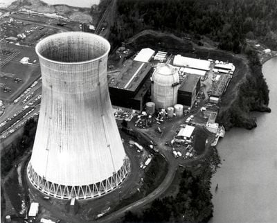
Trojan Nuclear Power Plant, Decommissioned nuclear power plant near Rainier, Oregon.

The Trojan Nuclear Power Plant was a pressurized water reactor facility located along Highway 30 east of Portland. The station generated electricity for Oregon before its closure in 1992.

Construction began in 1970 on the site of a former explosives factory. The facility was permanently shut down in 1992 following ongoing safety concerns.

The site became a focal point for community concerns about nuclear safety in Oregon. Local residents remain engaged with how the land has been transformed after its industrial purpose ended.

The site underwent complete decontamination and is now under environmental monitoring. Note that access is restricted and visits require prior arrangement through authorized channels.

The large cooling tower was demolished in a controlled implosion in 2006. This marked the first such demolition of its kind at a nuclear facility in the country.

The community of curious travelers

AroundUs brings together thousands of curated places, local tips, and hidden gems, enriched daily by 60,000 contributors worldwide.

Start exploring
Location
GPS coordinates
46.03830,-122.88500
Latest update
December 20, 2025 01:16
Around this place
Collins Beach
United States of America

Collins Beach

28.3 km
Nutty Narrows Bridge
United States of America

Nutty Narrows Bridge

12.3 km
Lewis and Clark Bridge
United States of America

Lewis and Clark Bridge

9.5 km
Ridgefield National Wildlife Refuge
United States of America

Ridgefield National Wildlife Refuge

28 km
Seaquest State Park
United States of America

Seaquest State Park

28.6 km
Warrior Rock Light
United States of America

Warrior Rock Light

22.4 km
Great Vow Zen Monastery
United States of America

Great Vow Zen Monastery

24.3 km
Paradise Point State Park
United States of America

Paradise Point State Park

23.7 km
Clatsop State Forest
United States of America

Clatsop State Forest

28.2 km
Hulda Klager Lilac Gardens
United States of America

Hulda Klager Lilac Gardens

18.7 km
Cedar Creek Grist Mill
United States of America

Cedar Creek Grist Mill

25.9 km
Mount Saint Helens Creation Center
United States of America

Mount Saint Helens Creation Center

26.5 km
Lelooska Museum
United States of America

Lelooska Museum

25.8 km
Thomas J. Flippin House
United States of America

Thomas J. Flippin House

25.9 km
Longview Community Church-Saint Helen's Addition
United States of America

Longview Community Church-Saint Helen's Addition

11.2 km
Cox–Williams House
United States of America

Cox–Williams House

20.7 km
Basalt Cobblestone Quarries District
United States of America

Basalt Cobblestone Quarries District

24 km
Caples House Museum
United States of America

Caples House Museum

17.5 km
Judge Columbia Lancaster House
United States of America

Judge Columbia Lancaster House

22.2 km
Grocery Outlet
United States of America

Grocery Outlet

18.2 km
Trestle Beach
United States of America

Trestle Beach

15.7 km
Columbia Theatre for the Performing Arts
United States of America

Columbia Theatre for the Performing Arts

12 km
Lyons Beach
United States of America

Lyons Beach

23.8 km
Columbia Theatre
United States of America

Columbia Theatre

20.6 km
Dibblees Beach
United States of America

Dibblees Beach

11.9 km
Goble Beach
United States of America

Goble Beach

2.3 km
Woodland Theatre
United States of America

Woodland Theatre

18.6 km
Ridgefield Community Library
United States of America

Ridgefield Community Library

26.9 km
Show the full map
Reviews
Share your experience

No review yet

Discussions
Start a discussion...

No discussion yet

« Trojan Nuclear Power Plant - Decommissioned nuclear power plant near Rainier, Oregon » is provided by Around Us (aroundus.com). Images and texts are derived from Wikimedia project under a Creative Commons license. You are allowed to copy, distribute, and modify copies of this page, under the conditions set by the license, as long as this note is clearly visible.

Discover hidden gems everywhere you go!

From secret cafés to breathtaking viewpoints, skip the crowded tourist spots and find places that match your style. Our app makes it easy with voice search, smart filtering, route optimization, and insider tips from travelers worldwide. Download now for the complete mobile experience.

Around Us App Screenshot

A unique approach to discovering new places

Le Figaro

All the places worth exploring

France Info

A tailor-made excursion in just a few clicks

20 Minutes

Around Us
Travel Guide & Maps
Download

Send to your phone

QR Code
1

Open the camera app on your mobile.

2

Point at the QR code with your camera. A notification will appear.

3

Tap the notification to open the link.