Grays River Covered Bridge

Log in to your account

AroundUs is a community-driven map of interesting places, built by curious explorers like you. It grows with every review, story, and photo you share.
Connect to save your favorite spots, contribute locations, and create personalized routes.
Continue with Google
Continue with Apple
Continue with X
Continue with Facebook
Continue with email
By continuing, you accept our Terms and Conditions and our Privacy Policy
Create an account
Add to collection
Map
Suggest a change
Share

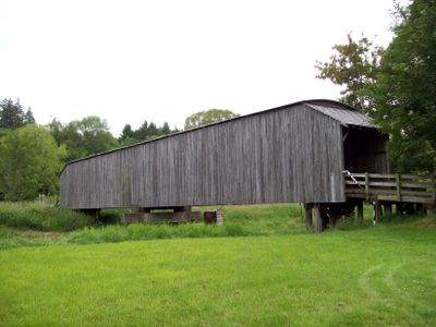
Grays River Covered Bridge, Covered bridge in Wahkiakum County, US.

Grays River Covered Bridge is a wooden structure spanning the Grays River with cedar shingle siding and interior Howe truss framing supporting the timber deck. The bridge accommodates vehicle traffic and features a modest width and height designed for the region's roads.

The bridge was constructed in the early 1900s, originally designed for horse-drawn wagons crossing the river. The roof was added shortly after initial construction to protect the wooden framework from the region's heavy moisture and rainfall.

The bridge serves as a gathering place during the annual Covered Bridge Festival, where the community celebrates local heritage through music, food, and shared traditions that connect people to this structure.

The bridge remains open to vehicle traffic and can be accessed from both sides of the river. Visitors should note that the narrow width and modest height can restrict passage for large vehicles or tall equipment.

This is the last functioning covered wooden bridge in Washington State that remains part of the public highway system. The structure represents a construction method from an earlier era that has largely disappeared from the rest of the region.

Location: Wahkiakum County

Inception: 1905

GPS coordinates: 46.35490,-123.58000

Latest update: December 12, 2025 16:40

Photos
Around this place
Astoria–Megler Bridge
United States of America

Astoria–Megler Bridge

26.6 km
Fort Astoria
United States of America

Fort Astoria

26.6 km
Astoria Column
United States of America

Astoria Column

26.6 km
John Jacob Astor Hotel
United States of America

John Jacob Astor Hotel

26.6 km
Columbia River Maritime Museum
United States of America

Columbia River Maritime Museum

26.3 km
United States lightship Columbia
United States of America

United States lightship Columbia

26.2 km
Captain George Conrad Flavel House
United States of America

Captain George Conrad Flavel House

26.7 km
Julia Butler Hansen Refuge for the Columbian White-Tailed Deer
United States of America

Julia Butler Hansen Refuge for the Columbian White-Tailed Deer

17.5 km
Bradley State Scenic Viewpoint
United States of America

Bradley State Scenic Viewpoint

23.3 km
Lewis and Clark National Wildlife Refuge
United States of America

Lewis and Clark National Wildlife Refuge

16 km
Columbia River Quarantine Station
United States of America

Columbia River Quarantine Station

21.2 km
Julia Butler Hansen Bridge
United States of America

Julia Butler Hansen Bridge

23.3 km
Deep River Pioneer Lutheran Church
United States of America

Deep River Pioneer Lutheran Church

7.9 km
Old Astoria City Hall
United States of America

Old Astoria City Hall

26.5 km
MV Tourist No. 2
United States of America

MV Tourist No. 2

24.3 km
Pioneer Church
United States of America

Pioneer Church

22.9 km
Pillar Rock
United States of America

Pillar Rock

10.8 km
Albert W. Ferguson House
United States of America

Albert W. Ferguson House

26.6 km
Christian Leinenweber House
United States of America

Christian Leinenweber House

25.1 km
Gustavus Holmes House
United States of America

Gustavus Holmes House

25.1 km
John N. Griffin House
United States of America

John N. Griffin House

26.6 km
Martin Foard House
United States of America

Martin Foard House

26.5 km
Peter and Maria Larson House
United States of America

Peter and Maria Larson House

25.4 km
Andrew Young House
United States of America

Andrew Young House

24.7 km
Old Grace Episcopal Church Rectory
United States of America

Old Grace Episcopal Church Rectory

26.6 km
Harlows Creek
United States of America

Harlows Creek

10.1 km
Pier 12
United States of America

Pier 12

26.6 km
Goonies House
United States of America

Goonies House

24.7 km
Show the full map
Reviews

Visited this place? Tap the stars to rate it and share your experience / photos with the community! Try now! You can cancel it anytime.

« Grays River Covered Bridge - Covered bridge in Wahkiakum County, US » is provided by Around Us (aroundus.com). Images and texts are derived from Wikimedia project under a Creative Commons license. You are allowed to copy, distribute, and modify copies of this page, under the conditions set by the license, as long as this note is clearly visible.

Discover hidden gems everywhere you go!

From secret cafés to breathtaking viewpoints, skip the crowded tourist spots and find places that match your style. Our app makes it easy with voice search, smart filtering, route optimization, and insider tips from travelers worldwide. Download now for the complete mobile experience.

Around Us App Screenshot

A unique approach to discovering new places

Le Figaro

All the places worth exploring

France Info

A tailor-made excursion in just a few clicks

20 Minutes