Enable Location

We need your location to show you interesting places around you

Discover nearby places

Find interesting locations and hidden gems around you

Precise directions

Get accurate directions and distances to places

Your location is never shared with other users. It's only used when you tap the location button.

Lewis and Clark State Recreation Site

Log in to your account

Start exploring — it's free

Trusted by 62,344 travelers worldwide

Continue with Google
Continue with Apple
or

We will send you a code to connect

By continuing, you accept our Terms and Conditions and our Privacy Policy

Check your inbox

We've sent a pincode in your inbox. Please enter the code below.

Lewis and Clark State Recreation Site

Lewis and Clark State Recreation Site, State park at Sandy River confluence, Multnomah County, United States

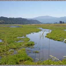
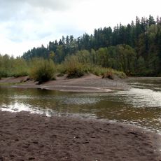
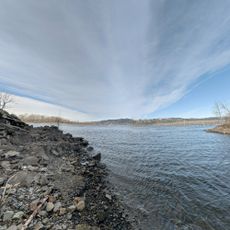
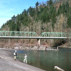
Lewis and Clark State Recreation Site is a state park located where the Sandy River flows, featuring open grassy areas with trees and riverbank access. The grounds include designated swimming areas, picnic spots, and a boat launch for visitors looking to enjoy water activities.

The land was gifted to Oregon by Multnomah County in 1936, with additional land purchased from private owners through 1961. This gradual assembly of properties created the public recreation space we see today.

The site bears the name of the famous 1805 expedition that explored this region and recorded observations about the river. Visitors walking along the water today can connect with the historical journey that passed through this landscape.

The park has a boat launch and a life jacket loaner station for visitors planning water activities. Wearing a life jacket is required during water use, so guests should be prepared for this safety rule.

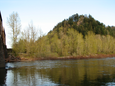
Broughton's Bluff, a 160-foot rock wall, marks the geological boundary between the Cascade Mountains and the Willamette Valley. Climbers use this natural formation year-round, making it a notable feature of the park.

The community of curious travelers

AroundUs brings together thousands of curated places, local tips, and hidden gems, enriched daily by 60,000 contributors worldwide.

Start exploring
Location
GPS coordinates
45.54100,-122.37700
Latest update
December 12, 2025 14:40
Around this place
Historic Columbia River Highway
United States of America

Historic Columbia River Highway

289 m
Steigerwald Lake National Wildlife Refuge
United States of America

Steigerwald Lake National Wildlife Refuge

6.4 km
Dabney State Recreation Area
United States of America

Dabney State Recreation Area

3.4 km
Liberty Theatre
United States of America

Liberty Theatre

5.4 km
Blue Lake Regional Park

Blue Lake Regional Park

5.6 km
Stark Street Bridge
United States of America

Stark Street Bridge

3.1 km
Rockwood Library
United States of America

Rockwood Library

8.3 km
Living Room
United States of America

Living Room

5.8 km
Gresham Carnegie Library
United States of America

Gresham Carnegie Library

6.2 km
Farrell Building
United States of America

Farrell Building

5.6 km
John Roffler House
United States of America

John Roffler House

5.9 km
Springdale School
United States of America

Springdale School

4.4 km
Gresham Library
United States of America

Gresham Library

6.3 km
Fairview-Columbia Library
United States of America

Fairview-Columbia Library

4.9 km
Dr. Herbert H. Hughes House
United States of America

Dr. Herbert H. Hughes House

7.2 km
Troutdale Methodist Episcopal Church
United States of America

Troutdale Methodist Episcopal Church

917 m
Fred Harlow House
United States of America

Fred Harlow House

540 m
William Gedamke House
United States of America

William Gedamke House

5.7 km
Emanuel and Christina Anderson House
United States of America

Emanuel and Christina Anderson House

6.8 km
Troutdale Library
United States of America

Troutdale Library

2.8 km
Charles and Fae Olson House
United States of America

Charles and Fae Olson House

7 km
Fairview City Jail
United States of America

Fairview City Jail

4.4 km
Troutdale Sandy River Bridge
United States of America

Troutdale Sandy River Bridge

289 m
Roy E. and Hildur L. Amundsen House
United States of America

Roy E. and Hildur L. Amundsen House

6.8 km
Sunrise Park
United States of America

Sunrise Park

2.1 km
Mt. Hood Theatre
United States of America

Mt. Hood Theatre

6.2 km
David and Marianne Ott House
United States of America

David and Marianne Ott House

6.8 km
Camas Public Library
United States of America

Camas Public Library

5.5 km
Show the full map
« Lewis and Clark State Recreation Site - State park at Sandy River confluence, Multnomah County, United States » is provided by Around Us (aroundus.com). Images and texts are derived from Wikimedia project under a Creative Commons license. You are allowed to copy, distribute, and modify copies of this page, under the conditions set by the license, as long as this note is clearly visible.

Discover hidden gems everywhere you go!

From secret cafés to breathtaking viewpoints, skip the crowded tourist spots and find places that match your style. Our app makes it easy with voice search, smart filtering, route optimization, and insider tips from travelers worldwide. Download now for the complete mobile experience.

Around Us App Screenshot

A unique approach to discovering new places

Le Figaro

All the places worth exploring

France Info

A tailor-made excursion in just a few clicks

20 Minutes

Around Us
Travel Guide & Maps
Download

Send to your phone

QR Code
1

Open the camera app on your mobile.

2

Point at the QR code with your camera. A notification will appear.

3

Tap the notification to open the link.