Enable Location

We need your location to show you interesting places around you

Discover nearby places

Find interesting locations and hidden gems around you

Precise directions

Get accurate directions and distances to places

Your location is never shared with other users. It's only used when you tap the location button.

Dabney State Recreation Area

Log in to your account

Start exploring — it's free

Trusted by 63,034 travelers worldwide

Continue with Google
Continue with Apple
or

We will send you a code to connect

By continuing, you accept our Terms and Conditions and our Privacy Policy

Check your inbox

We've sent a pincode in your inbox. Please enter the code below.

Dabney State Recreation Area
Discussion Reviews 1 Photos
2.5k Popularity

Dabney State Recreation Area, Nature reserve near Troutdale, US

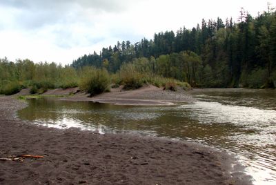
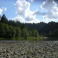
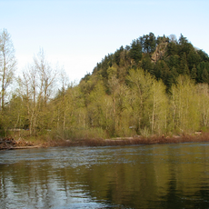
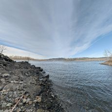
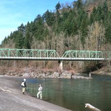
Dabney State Recreation Area is a nature reserve situated along the Sandy River with open beach areas and forested zones throughout. The landscape includes sandy banks for water access and wooded sections that provide shade and shelter.

The recreation area began in 1945 when Multnomah County received a land donation and expanded through additional acquisitions until 1968. These additions gradually shaped it into the park visitors see today.

The disc golf course draws players from across the Pacific Northwest who gather here regularly. This activity has become a focal point for outdoor enthusiasts in the area.

The park has life jacket loaner stations at two locations for visitors who plan to swim or boat. Water access points are distributed throughout the grounds for convenience.

The park experiences seasonal closures from November through March that affect restroom availability and water access. These periods of limited facility operation reflect the site's natural cycles.

The community of curious travelers

AroundUs brings together thousands of curated places, local tips, and hidden gems, enriched daily by 60,000 contributors worldwide.

Start exploring
Location
Operator
Oregon Parks and Recreation Department
GPS coordinates
45.51641,-122.35216
Latest update
December 12, 2025 17:42
Around this place
Historic Columbia River Highway
United States of America

Historic Columbia River Highway

3.1 km
Oxbow Regional Park
United States of America

Oxbow Regional Park

5.5 km
United States of America

Chanticleer Point

7.1 km
Steigerwald Lake National Wildlife Refuge
United States of America

Steigerwald Lake National Wildlife Refuge

6.7 km
Lewis and Clark State Recreation Site
United States of America

Lewis and Clark State Recreation Site

3.4 km
Liberty Theatre
United States of America

Liberty Theatre

8.7 km
Blue Lake Regional Park

Blue Lake Regional Park

8.5 km
Stark Street Bridge
United States of America

Stark Street Bridge

700 m
Living Room
United States of America

Living Room

6 km
Gresham Carnegie Library
United States of America

Gresham Carnegie Library

6.4 km
Springdale School
United States of America

Springdale School

1.8 km
Gresham Library
United States of America

Gresham Library

6.6 km
Fairview-Columbia Library
United States of America

Fairview-Columbia Library

7 km
Dr. Herbert H. Hughes House
United States of America

Dr. Herbert H. Hughes House

7.5 km
Troutdale Methodist Episcopal Church
United States of America

Troutdale Methodist Episcopal Church

3.4 km
Fred Harlow House
United States of America

Fred Harlow House

3.4 km
William Gedamke House
United States of America

William Gedamke House

5.4 km
Emanuel and Christina Anderson House
United States of America

Emanuel and Christina Anderson House

6.1 km
Troutdale Library
United States of America

Troutdale Library

4.7 km
Charles and Fae Olson House
United States of America

Charles and Fae Olson House

6.9 km
Fairview City Jail
United States of America

Fairview City Jail

6.9 km
Troutdale Sandy River Bridge
United States of America

Troutdale Sandy River Bridge

3.1 km
Roy E. and Hildur L. Amundsen House
United States of America

Roy E. and Hildur L. Amundsen House

7.3 km
Sunrise Park
United States of America

Sunrise Park

3.3 km
Mt. Hood Theatre
United States of America

Mt. Hood Theatre

6.2 km
David and Marianne Ott House
United States of America

David and Marianne Ott House

5.5 km
Camas Public Library
United States of America

Camas Public Library

8.8 km
Rooster Rock
United States of America

Rooster Rock

8.5 km
Show the full map
Reviews
Share your experience

No review yet

Discussions
Start a discussion...

No discussion yet

« Dabney State Recreation Area - Nature reserve near Troutdale, US » is provided by Around Us (aroundus.com). Images and texts are derived from Wikimedia project under a Creative Commons license. You are allowed to copy, distribute, and modify copies of this page, under the conditions set by the license, as long as this note is clearly visible.

Discover hidden gems everywhere you go!

From secret cafés to breathtaking viewpoints, skip the crowded tourist spots and find places that match your style. Our app makes it easy with voice search, smart filtering, route optimization, and insider tips from travelers worldwide. Download now for the complete mobile experience.

Around Us App Screenshot

A unique approach to discovering new places

Le Figaro

All the places worth exploring

France Info

A tailor-made excursion in just a few clicks

20 Minutes

Around Us
Travel Guide & Maps
Download

Send to your phone

QR Code
1

Open the camera app on your mobile.

2

Point at the QR code with your camera. A notification will appear.

3

Tap the notification to open the link.