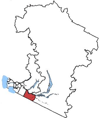
Abbotsford, federal electoral district of Canada
Location: British Columbia
Inception: 2004
GPS coordinates: 49.09420,-122.26700
Latest update: April 3, 2025 00:28
Lieu historique national du Fort-Langley
23.7 km
Greater Vancouver Zoo
16 km
Abbotsford Entertainment & Sports Centre
7.2 km
Westminster Abbey
6.6 km
CFB Chilliwack
22.2 km
Gur Sikh Temple
5.6 km
Castle Fun Park
6.9 km
Stave Falls Dam
16.4 km
Mission Bridge
4.3 km
Prospera Centre
23.3 km
Ruskin Dam
15.3 km
Xá:ytem
6.5 km
Rolley Lake Provincial Park
18.7 km
Davis Lake Provincial Park
23 km
Clayburn
1.2 km
Kanaka Creek Regional Park
22.6 km
Mission Railway Bridge
4.3 km
Chilliwack Museum and Historical Society
24.1 km
Cultus Lake Provincial Park
22.3 km
Alder Alley
15.6 km
Gur Sikh Temple
5.6 km
Whonnock General Store
17.6 km
Clayburn Church
1.6 km
Clayburn School
1.6 km
Whonnock sugar maple trees
18.6 km
Whonnock Post Office
17.6 km
Fort Langley storehouse
23.6 km
Trethewey House
6.3 kmReviews
Visited this place? Tap the stars to rate it and share your experience / photos with the community! Try now! You can cancel it anytime.
Discover hidden gems everywhere you go!
From secret cafés to breathtaking viewpoints, skip the crowded tourist spots and find places that match your style. Our app makes it easy with voice search, smart filtering, route optimization, and insider tips from travelers worldwide. Download now for the complete mobile experience.
A unique approach to discovering new places❞
— Le Figaro
All the places worth exploring❞
— France Info
A tailor-made excursion in just a few clicks❞
— 20 Minutes