Chest opened
+${chestReward.xp} XP
Explorer
NOUVEAU ×${chestReward.collectible.quantity}
tapez pour fermer
Chest locked

Open chests in the app

Around Us is built for your phone — chests unlock when you walk, explore and capture nearby places.

Enable Location

We need your location to show you interesting places around you

Discover nearby places

Find interesting locations and hidden gems around you

Precise directions

Get accurate directions and distances to places

Your location is never shared with other users. It's only used when you tap the location button.

Log in to your account

Start exploring — it's free

Trusted by 73,002 travelers worldwide

Continue with Google
Continue with Apple
or

We will send you a code to connect

By continuing, you accept our Terms and Conditions and our Privacy Policy

Check your inbox

We've sent a pincode in your inbox. Please enter the code below.

Kern Island Canal
Discussion Reviews Photo
1.2k Popularity

Kern Island Canal, Irrigation canal in Kern County, California.

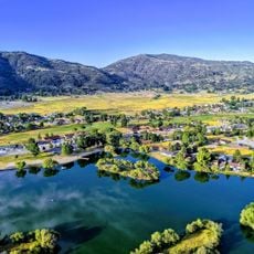
Kern Island Canal is an irrigation waterway that flows south from Bakersfield and supplies water to the region's farming areas. The system branches into sections that distribute water across different farmland zones to serve various crops.

The canal was constructed in the 1890s as a major water infrastructure project for the region. This waterway became essential to opening up arid lands for farming and settlement in the area.

The canal reflects the region's farming roots and how water shaped the lives of local farmers for generations. You can see how irrigation transformed the dry lands south of Bakersfield into productive agricultural areas.

The canal is visible from roads and accessible from various points along the routes south of Bakersfield. You can view the waterway and observe how it serves the farmlands, giving perspective on the region's agricultural landscape.

The canal was dug using pioneering construction methods of its era that later became documented in regional museums. These techniques showcase the engineering achievements that transformed California's interior in the late 1800s.

The community of curious travelers

AroundUs brings together thousands of curated places, local tips, and hidden gems, enriched daily by 60,000 contributors worldwide.

Start exploring
Location
GPS coordinates
35.31530,-119.02100
Latest update
December 14, 2025 18:02
Around this place
Tehachapi Loop
United States of America

Tehachapi Loop

45.8 km
California Correctional Institution
United States of America

California Correctional Institution

47 km
United States of America

Wasco State Prison

46.9 km
Buck Owens Crystal Palace
United States of America

Buck Owens Crystal Palace

8.1 km
Kevin Harvick's Kern Raceway
United States of America

Kevin Harvick's Kern Raceway

15 km
Cesar E. Chavez National Monument
United States of America

Cesar E. Chavez National Monument

42.9 km
Fox Theater
United States of America

Fox Theater

6.9 km
Memorial Stadium
United States of America

Memorial Stadium

11.3 km
California Living Museum
United States of America

California Living Museum

18 km
Kern County Museum
United States of America

Kern County Museum

8.7 km
Wasco Union High School
United States of America

Wasco Union High School

42.8 km
United States of America

Antimony Peak

49.5 km
Bear Mountain
United States of America

Bear Mountain

36.9 km
Beale Memorial Clock Tower
United States of America

Beale Memorial Clock Tower

8.7 km
Bakersfield City Hall
United States of America

Bakersfield City Hall

6.4 km
Bakersfield Museum of Art
United States of America

Bakersfield Museum of Art

7 km
Bakersfield California Building
United States of America

Bakersfield California Building

6.6 km
The Fort
United States of America

The Fort

44.3 km
Buena Vista Museum of Natural History
United States of America

Buena Vista Museum of Natural History

6.9 km
Baker Branch Library
United States of America

Baker Branch Library

8.1 km
Tevis Block
United States of America

Tevis Block

6.8 km
Calloway Canal
United States of America

Calloway Canal

29.8 km
Jastro Building
United States of America

Jastro Building

6.8 km
Shafter Research Station
United States of America

Shafter Research Station

33.5 km
Kern County Chamber of Commerce Building
United States of America

Kern County Chamber of Commerce Building

8.7 km
Kern Veterans Memorial
United States of America

Kern Veterans Memorial

6.5 km
4 Island Lake Beach
United States of America

4 Island Lake Beach

37.2 km
Alano Club Of Bakersfield
United States of America

Alano Club Of Bakersfield

8.4 km
Show the full map
Reviews
Share your experience

No review yet

Discussions
Start a discussion...

No discussion yet

« Kern Island Canal - Irrigation canal in Kern County, California » is provided by Around Us (aroundus.com). Images and texts are derived from Wikimedia project under a Creative Commons license. You are allowed to copy, distribute, and modify copies of this page, under the conditions set by the license, as long as this note is clearly visible.

Discover hidden gems everywhere you go!

From secret cafés to breathtaking viewpoints, skip the crowded tourist spots and find places that match your style. Our app makes it easy with voice search, smart filtering, route optimization, and insider tips from travelers worldwide. Download now for the complete mobile experience.

Around Us App Screenshot

A unique approach to discovering new places

Le Figaro

All the places worth exploring

France Info

A tailor-made excursion in just a few clicks

20 Minutes

Around Us
Travel Guide & Maps
Download

Send to your phone

QR Code
1

Open the camera app on your mobile.

2

Point at the QR code with your camera. A notification will appear.

3

Tap the notification to open the link.