Chest opened
+${chestReward.xp} XP
Explorer
NOUVEAU ×${chestReward.collectible.quantity}
tapez pour fermer
Chest locked

Open chests in the app

Around Us is built for your phone — chests unlock when you walk, explore and capture nearby places.

Enable Location

We need your location to show you interesting places around you

Discover nearby places

Find interesting locations and hidden gems around you

Precise directions

Get accurate directions and distances to places

Your location is never shared with other users. It's only used when you tap the location button.

Kern River Oil Field

Log in to your account

Start exploring — it's free

Trusted by 72,992 travelers worldwide

Continue with Google
Continue with Apple
or

We will send you a code to connect

By continuing, you accept our Terms and Conditions and our Privacy Policy

Check your inbox

We've sent a pincode in your inbox. Please enter the code below.

Kern River Oil Field
Discussion Reviews 1 Photos
18.5k Popularity

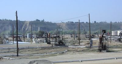
Kern River Oil Field, oil field in the San Joaquin Valley of California

Kern River Oil Field is an oil field north of Bakersfield in California where hundreds of pumpjacks continuously extract oil from the ground. The landscape spans a large area with active wells, pipelines, and infrastructure that shows the intensive industrial use of the land.

The first oil discovery occurred in 1899 when James and Jonathan Ellwood accidentally found oil about 45 feet below the surface and transported the first barrels to a nearby railroad station. Commercial production began shortly after, and by 1901 more than 500 wells were active, making the area one of California's largest oil regions.

The site is located about 7 kilometers northeast of Bakersfield and can be reached via Round Mountain Road about 1 kilometer east of China Grade Loop. For a visit to the historical well, it is recommended to arrange an appointment in advance to confirm access and current conditions.

The original oil discovery site can still be visited today and bears a historical marker noting the accidental find of 1899. This location shows how early oil exploration began with simple tools and changed the economic path for the entire region.

The community of curious travelers

AroundUs brings together thousands of curated places, local tips, and hidden gems, enriched daily by 60,000 contributors worldwide.

Start exploring
Location
GPS coordinates
35.45640,-118.98300
Latest update
February 16, 2026 23:41
Around this place
Tehachapi Loop
United States of America

Tehachapi Loop

49.5 km
California Correctional Institution
United States of America

California Correctional Institution

53.8 km
United States of America

Wasco State Prison

41.5 km
Buck Owens Crystal Palace
United States of America

Buck Owens Crystal Palace

9.5 km
Kevin Harvick's Kern Raceway
United States of America

Kevin Harvick's Kern Raceway

11.1 km
Cesar E. Chavez National Monument
United States of America

Cesar E. Chavez National Monument

46 km
Fox Theater
United States of America

Fox Theater

9.5 km
Memorial Stadium
United States of America

Memorial Stadium

5.6 km
California Living Museum
United States of America

California Living Museum

9.2 km
Kern River Canyon
United States of America

Kern River Canyon

39 km
Kern County Museum
United States of America

Kern County Museum

7.8 km
The Forty Acres
United States of America

The Forty Acres

43.9 km
Wasco Union High School
United States of America

Wasco Union High School

36.3 km
Bear Mountain
United States of America

Bear Mountain

42 km
Beale Memorial Clock Tower
United States of America

Beale Memorial Clock Tower

7.8 km
Bakersfield City Hall
United States of America

Bakersfield City Hall

9.9 km
Bakersfield Museum of Art
United States of America

Bakersfield Museum of Art

9.1 km
Bakersfield California Building
United States of America

Bakersfield California Building

9.6 km
The Fort
United States of America

The Fort

55.5 km
Buena Vista Museum of Natural History
United States of America

Buena Vista Museum of Natural History

9.3 km
Baker Branch Library
United States of America

Baker Branch Library

8.1 km
Tevis Block
United States of America

Tevis Block

9.5 km
Calloway Canal
United States of America

Calloway Canal

24.3 km
Jastro Building
United States of America

Jastro Building

9.6 km
Shafter Research Station
United States of America

Shafter Research Station

28 km
Kern County Chamber of Commerce Building
United States of America

Kern County Chamber of Commerce Building

7.7 km
Kern Veterans Memorial
United States of America

Kern Veterans Memorial

9.6 km
4 Island Lake Beach
United States of America

4 Island Lake Beach

44.2 km
Show the full map
Reviews
Share your experience

No review yet

Discussions
Start a discussion...

No discussion yet

« Kern River Oil Field - oil field in the San Joaquin Valley of California » is provided by Around Us (aroundus.com). Images and texts are derived from Wikimedia project under a Creative Commons license. You are allowed to copy, distribute, and modify copies of this page, under the conditions set by the license, as long as this note is clearly visible.

Discover hidden gems everywhere you go!

From secret cafés to breathtaking viewpoints, skip the crowded tourist spots and find places that match your style. Our app makes it easy with voice search, smart filtering, route optimization, and insider tips from travelers worldwide. Download now for the complete mobile experience.

Around Us App Screenshot

A unique approach to discovering new places

Le Figaro

All the places worth exploring

France Info

A tailor-made excursion in just a few clicks

20 Minutes

Around Us
Travel Guide & Maps
Download

Send to your phone

QR Code
1

Open the camera app on your mobile.

2

Point at the QR code with your camera. A notification will appear.

3

Tap the notification to open the link.