Enable Location

We need your location to show you interesting places around you

Discover nearby places

Find interesting locations and hidden gems around you

Precise directions

Get accurate directions and distances to places

Your location is never shared with other users. It's only used when you tap the location button.

Red Cliffs National Conservation Area

Log in to your account

Start exploring — it's free

Trusted by 61,500 travelers worldwide

Continue with Google
Continue with Apple
or

We will send you a code to connect

By continuing, you accept our Terms and Conditions and our Privacy Policy

Check your inbox

We've sent a pincode in your inbox. Please enter the code below.

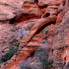
Red Cliffs National Conservation Area, National Conservation Area in Washington County, Utah

Description

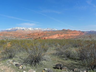
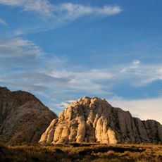
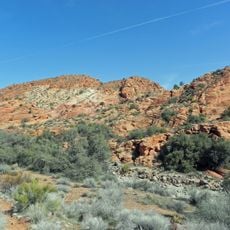
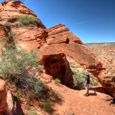
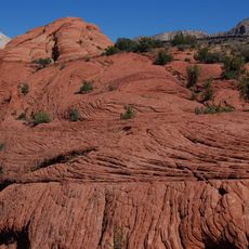
Red Cliffs National Conservation Area is a protected landscape spanning roughly 45,000 acres where the Mojave Desert, Great Basin, and Colorado Plateau meet. This location creates diverse rock formations and different habitat zones that characterize the area.

History

The area gained federal protection status in 2009 after management efforts began between federal authorities and local communities in 1996. This collaboration eventually resulted in official conservation designation.

Culture

The land contains petroglyphs and archaeological sites that show evidence of Native American presence across different periods. While hiking through the landscape, visitors encounter these carved markings embedded in the rock faces.

Practical

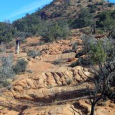
The area offers over 200 kilometers of trails for hiking, mountain biking, and horseback riding with camping available at Red Cliffs Recreation Area. Plan time for exploration since trails vary in difficulty and weather conditions change throughout the year.

Did you know?

The area protects a population of Mojave Desert tortoises, a rare and endangered species living in the region. Protecting this animal was a main reason for creating the conservation area.

Location
Inception
2009
Operator
Bureau of Land Management
GPS coordinates
37.15600,-113.55400
Latest update
December 9, 2025 18:46

AroundUs brings together thousands of curated places, local tips, and hidden gems, enriched daily by 60,000 contributors worldwide. Discover all places nearby (Washington County).

Around this place
Snow Canyon State Park
United States of America

Snow Canyon State Park

9.3 km
Sand Hollow State Park
United States of America

Sand Hollow State Park

16.4 km
Tuacahn
United States of America

Tuacahn

10.1 km
Quail Creek State Park
United States of America

Quail Creek State Park

15.5 km
Brigham Young Winter Home and Office
United States of America

Brigham Young Winter Home and Office

5.7 km
Jacob Hamblin House
United States of America

Jacob Hamblin House

9.7 km
Cottonwood Canyon Wilderness
United States of America

Cottonwood Canyon Wilderness

8.9 km
Red Mountain Wilderness
United States of America

Red Mountain Wilderness

16.3 km
Elephant Arch
United States of America

Elephant Arch

5.8 km
United States of America

Padre Canyon

9.5 km
St. George Opera House
United States of America

St. George Opera House

5.5 km
Brigham and Amelia Young Home

Brigham and Amelia Young Home

5.7 km
Old Washington County Courthouse
United States of America

Old Washington County Courthouse

5.6 km
Robert D. Covington House
United States of America

Robert D. Covington House

4.9 km
Thomas Judd House
United States of America

Thomas Judd House

5.9 km
George and Bertha Graff House
United States of America

George and Bertha Graff House

8.9 km
Orson Pratt House
United States of America

Orson Pratt House

5.9 km
Hans George Hafen House
United States of America

Hans George Hafen House

9.1 km
Washington Relief Society Hall
United States of America

Washington Relief Society Hall

4.4 km
Leeds Tithing Office
United States of America

Leeds Tithing Office

19.2 km
Frederick, Jr., and Mary F. Reber House
United States of America

Frederick, Jr., and Mary F. Reber House

9.6 km
Frederick and Anna Maria Reber House
United States of America

Frederick and Anna Maria Reber House

9.1 km
Elephant Arch
United States of America

Elephant Arch

5.8 km
Quail Creek Reservoir
United States of America

Quail Creek Reservoir

14.4 km
Cottontown Village
United States of America

Cottontown Village

4.4 km
Main Building of Dixie College
United States of America

Main Building of Dixie College

6 km
Pioneer Courthouse
United States of America

Pioneer Courthouse

5.7 km
Petrified Sand Dunes
United States of America

Petrified Sand Dunes

10.3 km
Show the full map
« Red Cliffs National Conservation Area - National Conservation Area in Washington County, Utah » is provided by Around Us (aroundus.com). Images and texts are derived from Wikimedia project under a Creative Commons license. You are allowed to copy, distribute, and modify copies of this page, under the conditions set by the license, as long as this note is clearly visible.

Discover hidden gems everywhere you go!

From secret cafés to breathtaking viewpoints, skip the crowded tourist spots and find places that match your style. Our app makes it easy with voice search, smart filtering, route optimization, and insider tips from travelers worldwide. Download now for the complete mobile experience.

Around Us App Screenshot

A unique approach to discovering new places

Le Figaro

All the places worth exploring

France Info

A tailor-made excursion in just a few clicks

20 Minutes

Around Us
Travel Guide & Maps
Download

Send to your phone

QR Code
1

Open the camera app on your mobile.

2

Point at the QR code with your camera. A notification will appear.

3

Tap the notification to open the link.