De’ek wadapush

Log in to your account

AroundUs is a community-driven map of interesting places, built by curious explorers like you. It grows with every review, story, and photo you share.
Connect to save your favorite spots, contribute locations, and create personalized routes.
Continue with Google
Continue with Apple
Continue with X
Continue with Facebook
Continue with email
By continuing, you accept our Terms and Conditions and our Privacy Policy
Create an account
Add to collection
Map
Suggest a change
Share

De’ek wadapush, Rock formation and historic place in Douglas County, United States

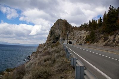
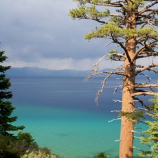
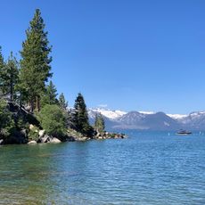
De'ek wadapush is a rock formation made of andesite in Douglas County, created from volcanic activity and visible from considerable distances. The structure rises distinctly from the surrounding landscape and displays characteristic geological features of the region.

The rock formation was created through volcanic processes millions of years ago and later added to the National Register of Historic Places. This recognition highlights its importance to regional history and heritage.

The Washoe people hold this rock sacred and have performed ceremonies here for generations, connecting their spiritual practices to the landscape. This place remains important to Native American communities who visit to maintain their traditions.

Visitors can find the formation at coordinates 39.046597, -119.948056 with multiple hiking trails providing access to viewing areas. The trails vary in difficulty, so visitors should bring proper footwear and water.

Two tunnels were constructed through the rock formation in 1931 and 1957, connecting modern infrastructure with this natural geological feature. These passages show how human development shaped the landscape.

Location: Douglas County

Made from material: andesite

GPS coordinates: 39.04660,-119.94806

Latest update: December 11, 2025 11:09

Photos
Around this place
Emerald Bay State Park
United States of America

Emerald Bay State Park

16.3 km
Vikingsholm
United States of America

Vikingsholm

17.3 km
Thunderbird Lodge
United States of America

Thunderbird Lodge

14.3 km
D. L. Bliss State Park
United States of America

D. L. Bliss State Park

15.1 km
Fallen Leaf Lake
United States of America

Fallen Leaf Lake

17.1 km
Harveys Outdoor Arena
United States of America

Harveys Outdoor Arena

9.4 km
Ed Z'berg Sugar Pine Point State Park
United States of America

Ed Z'berg Sugar Pine Point State Park

15.1 km
Rubicon Point Light
United States of America

Rubicon Point Light

13.9 km
SS Tahoe
United States of America

SS Tahoe

5 km
Casino Fandango
United States of America

Casino Fandango

17.9 km
Eagle Falls Trailhead
United States of America

Eagle Falls Trailhead

17.7 km
Lake Tahoe State Park
United States of America

Lake Tahoe State Park

14.7 km
Spooner Lake
United States of America

Spooner Lake

7.5 km
Dangberg Home Ranch Historic Park
United States of America

Dangberg Home Ranch Historic Park

17.6 km
Friday's Station
United States of America

Friday's Station

9.1 km
Pope Estate
United States of America

Pope Estate

14.7 km
Rubicon Peak
United States of America

Rubicon Peak

17.3 km
United States of America

East Peak

12.1 km
Minden Elementary School
United States of America

Minden Elementary School

18.8 km
Douglas County Courthouse
United States of America

Douglas County Courthouse

18.9 km
Round Hill Pines Beach Resort
United States of America

Round Hill Pines Beach Resort

6.3 km
Minden Wool Warehouse
United States of America

Minden Wool Warehouse

18.9 km
Taylor Creek Stream Profile Chamber
United States of America

Taylor Creek Stream Profile Chamber

15.6 km
Reese-Johnson-Virgin House
United States of America

Reese-Johnson-Virgin House

10.2 km
Edgewood Tahoe Golf Course
United States of America

Edgewood Tahoe Golf Course

8.8 km
Rainbow Trail
United States of America

Rainbow Trail

15.4 km
Stewart Indian School Cultural Center & Museum
United States of America

Stewart Indian School Cultural Center & Museum

18.3 km
Genoa Historic District
United States of America

Genoa Historic District

9.9 km
Show the full map
Reviews

Visited this place? Tap the stars to rate it and share your experience / photos with the community! Try now! You can cancel it anytime.

« De’ek wadapush - Rock formation and historic place in Douglas County, United States » is provided by Around Us (aroundus.com). Images and texts are derived from Wikimedia project under a Creative Commons license. You are allowed to copy, distribute, and modify copies of this page, under the conditions set by the license, as long as this note is clearly visible.

Discover hidden gems everywhere you go!

From secret cafés to breathtaking viewpoints, skip the crowded tourist spots and find places that match your style. Our app makes it easy with voice search, smart filtering, route optimization, and insider tips from travelers worldwide. Download now for the complete mobile experience.

Around Us App Screenshot

A unique approach to discovering new places

Le Figaro

All the places worth exploring

France Info

A tailor-made excursion in just a few clicks

20 Minutes