Enable Location

We need your location to show you interesting places around you

Discover nearby places

Find interesting locations and hidden gems around you

Precise directions

Get accurate directions and distances to places

Your location is never shared with other users. It's only used when you tap the location button.

Friday's Station

Log in to your account

Start exploring — it's free

Trusted by 61,343 travelers worldwide

Continue with Google
Continue with Apple
or

We will send you a code to connect

By continuing, you accept our Terms and Conditions and our Privacy Policy

Check your inbox

We've sent a pincode in your inbox. Please enter the code below.

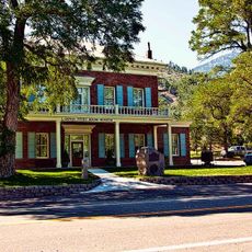
Friday's Station, Historical post station in Stateline, United States

Description

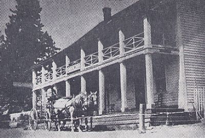
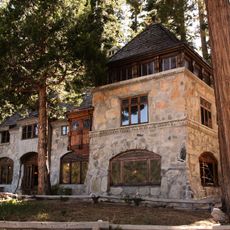
Friday's Station is a two-story white wood-frame building located at the California-Nevada border that originally functioned as a relay station. The main structure houses a restaurant and saloon on the lower level, while the 7.6-acre property also contains a blacksmith shop and stables dating to 1850.

History

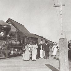
The station was built in 1860 and served as a critical stop for the Pony Express mail service and a military post for the Union Army during the Civil War. It was positioned on a major route connecting California and Nevada, making it vital to both communication and troop movements of the era.

Culture

The station served as a gathering point for travelers crossing the Sierra Nevada, offering food and shelter during their journeys. People relied on this place as a necessary stop where they could tend to their animals and rest before continuing onward.

Practical

The property is accessible and well preserved, allowing visitors to walk through and understand the original layout and structures. It is worth spending time exploring both the blacksmith shop and stable buildings to gain a complete sense of how the station operated as a working compound.

Did you know?

This location is the only remaining intact Pony Express station in Nevada, earning recognition on the National Register of Historic Places since 1986. Its survival makes it a rare example of a complete working station from that era.

Location
GPS coordinates
38.96565,-119.93581
Latest update
December 14, 2025 09:41

AroundUs brings together thousands of curated places, local tips, and hidden gems, enriched daily by 60,000 contributors worldwide. Discover all places nearby (Stateline).

Around this place
Emerald Bay State Park
United States of America

Emerald Bay State Park

13.7 km
Vikingsholm
United States of America

Vikingsholm

14.9 km
D. L. Bliss State Park
United States of America

D. L. Bliss State Park

14.4 km
Freel Peak
United States of America

Freel Peak

12.4 km
Fallen Leaf Lake
United States of America

Fallen Leaf Lake

11.9 km
Harveys Outdoor Arena
United States of America

Harveys Outdoor Arena

836 m
Rubicon Point Light
United States of America

Rubicon Point Light

14.2 km
SS Tahoe
United States of America

SS Tahoe

14.1 km
De’ek wadapush
United States of America

De’ek wadapush

9.1 km
Eagle Falls Trailhead
United States of America

Eagle Falls Trailhead

15.3 km
Jobs Peak
United States of America

Jobs Peak

13.6 km
Dangberg Home Ranch Historic Park
United States of America

Dangberg Home Ranch Historic Park

12.8 km
Pope Estate
United States of America

Pope Estate

9.9 km
United States of America

East Peak

3.6 km
Minden Flour Milling Company
United States of America

Minden Flour Milling Company

15 km
Minden Elementary School
United States of America

Minden Elementary School

14.7 km
Douglas County Courthouse
United States of America

Douglas County Courthouse

15 km
Round Hill Pines Beach Resort
United States of America

Round Hill Pines Beach Resort

3.1 km
Minden Wool Warehouse
United States of America

Minden Wool Warehouse

14.9 km
Farmer's Bank of Carson Valley
United States of America

Farmer's Bank of Carson Valley

15.1 km
Carson Valley Improvement Club Hall
United States of America

Carson Valley Improvement Club Hall

14.9 km
Farmer's Bank of Carson Valley
United States of America

Farmer's Bank of Carson Valley

15 km
Taylor Creek Stream Profile Chamber
United States of America

Taylor Creek Stream Profile Chamber

10.9 km
Reese-Johnson-Virgin House
United States of America

Reese-Johnson-Virgin House

9 km
Edgewood Tahoe Golf Course
United States of America

Edgewood Tahoe Golf Course

673 m
Rainbow Trail
United States of America

Rainbow Trail

10.7 km
Fallen Leaf Chapel
United States of America

Fallen Leaf Chapel

15.1 km
Genoa Historic District
United States of America

Genoa Historic District

8.4 km
Show the full map
« Friday's Station - Historical post station in Stateline, United States » is provided by Around Us (aroundus.com). Images and texts are derived from Wikimedia project under a Creative Commons license. You are allowed to copy, distribute, and modify copies of this page, under the conditions set by the license, as long as this note is clearly visible.

Discover hidden gems everywhere you go!

From secret cafés to breathtaking viewpoints, skip the crowded tourist spots and find places that match your style. Our app makes it easy with voice search, smart filtering, route optimization, and insider tips from travelers worldwide. Download now for the complete mobile experience.

Around Us App Screenshot

A unique approach to discovering new places

Le Figaro

All the places worth exploring

France Info

A tailor-made excursion in just a few clicks

20 Minutes

Around Us
Travel Guide & Maps
Download

Send to your phone

QR Code
1

Open the camera app on your mobile.

2

Point at the QR code with your camera. A notification will appear.

3

Tap the notification to open the link.