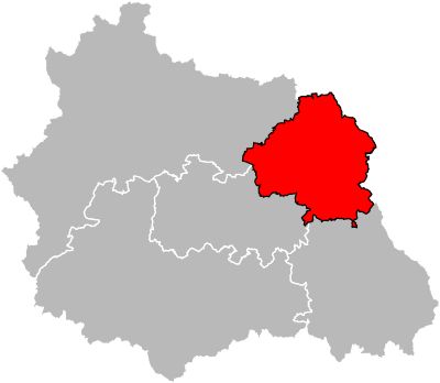
Arrondissement of Thiers, arrondissement of France
Location: Puy-de-Dôme
Capital city: Thiers
Shares border with: arrondissement of Vichy, arrondissement of Roanne, arrondissement of Montbrison, arrondissement of Ambert, arrondissement of Clermont-Ferrand, arrondissement of Riom
GPS coordinates: 45.85750,3.54222
Latest update: March 4, 2025 09:56
Château de Ravel
13.8 km
Livradois-Forez Regional Natural Park
19.3 km
Château de Randan
22.6 km
Château de Châteldon
13.3 km
Cutlery Museum
594 m
Ramparts of Thiers
654 m
Château d'Aulteribe
9.8 km
Puy de Montoncel
14.3 km
Église Saint-Genès de Thiers
658 m
Leisure centre of Iloa
4.7 km
Creux de l'Enfer
976 m
Château de Barante
4.4 km
Forges Mondière
967 m
Château de Mauzun
19.1 km
Château de Montmorin
22.9 km
Maison du Piroux à Thiers
562 m
Abbaye de Montpeyroux
9.7 km
Usine du May
989 m
Château de la Chassaigne
2.4 km
Abbaye du Moutier
787 m
Église Saint-Cerneuf de Billom
21.9 km
Église Saint-Jean de Thiers
905 m
Église Saint-Julien de Chauriat
23.6 km
Musée de la Céramique de Lezoux
12.7 km
Montguerlhe
5.1 km
Pont de Moutier
642 m
Couvent des Minimes de Beauregard-l'Évêque
20.5 km
Château des Horts
851 mReviews
Visited this place? Tap the stars to rate it and share your experience / photos with the community! Try now! You can cancel it anytime.
Discover hidden gems everywhere you go!
From secret cafés to breathtaking viewpoints, skip the crowded tourist spots and find places that match your style. Our app makes it easy with voice search, smart filtering, route optimization, and insider tips from travelers worldwide. Download now for the complete mobile experience.
A unique approach to discovering new places❞
— Le Figaro
All the places worth exploring❞
— France Info
A tailor-made excursion in just a few clicks❞
— 20 Minutes