Enable Location

We need your location to show you interesting places around you

Discover nearby places

Find interesting locations and hidden gems around you

Precise directions

Get accurate directions and distances to places

Your location is never shared with other users. It's only used when you tap the location button.

Jarbidge Wilderness

Log in to your account

Start exploring — it's free

Trusted by 62,187 travelers worldwide

Continue with Google
Continue with Apple
or

We will send you a code to connect

By continuing, you accept our Terms and Conditions and our Privacy Policy

Check your inbox

We've sent a pincode in your inbox. Please enter the code below.

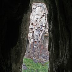
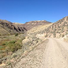
Jarbidge Wilderness, Protected mountain wilderness in northeastern Nevada, United States

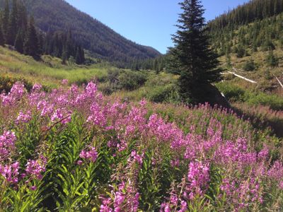
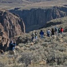
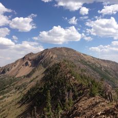
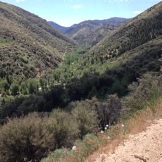
Jarbidge Wilderness is a protected mountain area in northeastern Nevada covering approximately 113,000 acres. The region contains mountain ranges, deep canyons, and dense forests situated within the Humboldt-Toiyabe National Forest.

This area became Nevada's first officially designated wilderness in 1964, with major expansion occurring in 1989. The designation marked a turning point for wilderness protection within the state.

The name Jarbidge comes from the Shoshone language and refers to supernatural beings that indigenous peoples believed inhabited these mountains. Local traditions still connect the area to these spiritual beliefs and the mountain spirits.

Visitors should prepare for limited services and changing weather, with cold winters and moderate summers in the mountains. Good equipment and planning are essential since the terrain is remote and exposed.

The area contains ten peaks rising above 10,000 feet, creating distinct forest zones. These high summits generate varied ecological conditions supporting rare alpine plants and diverse wildlife populations.

The community of curious travelers

AroundUs brings together thousands of curated places, local tips, and hidden gems, enriched daily by 60,000 contributors worldwide.

Start exploring
Location
Operator
United States Forest Service
GPS coordinates
41.76140,-115.32000
Latest update
December 9, 2025 18:45
Around this place
Snake River Canyon
United States of America

Snake River Canyon

119.4 km
Perrine Bridge
United States of America

Perrine Bridge

117.6 km
Hagerman Fossil Beds National Monument
United States of America

Hagerman Fossil Beds National Monument

119 km
Twin Falls Idaho Temple
United States of America

Twin Falls Idaho Temple

117 km
Owyhee River Wilderness
United States of America

Owyhee River Wilderness

117 km
Pillar Falls
United States of America

Pillar Falls

118.6 km
Wild Horse State Recreation Area
United States of America

Wild Horse State Recreation Area

41.1 km
Bruneau – Jarbidge Rivers Wilderness
United States of America

Bruneau – Jarbidge Rivers Wilderness

75 km
Big Jacks Creek Wilderness
United States of America

Big Jacks Creek Wilderness

100 km
Elko County Courthouse
United States of America

Elko County Courthouse

109.7 km
A. N. Tanner House
United States of America

A. N. Tanner House

118.9 km
United States of America

Gold Creek Ranger Station

29.5 km
Owsley Bridge
United States of America

Owsley Bridge

117.2 km
Maverick Canyon
United States of America

Maverick Canyon

97.7 km
Marys River Peak
United States of America

Marys River Peak

3.4 km
Buhl IOOF Building
United States of America

Buhl IOOF Building

104 km
Ramona Theatre
United States of America

Ramona Theatre

104 km
O. J. Daniels House
United States of America

O. J. Daniels House

119.4 km
Burton Morse House
United States of America

Burton Morse House

113.9 km
Achille Duquesne House
United States of America

Achille Duquesne House

107.4 km
UEC Elko Cinema 6
United States of America

UEC Elko Cinema 6

110.5 km
UEC Crystal 5
United States of America

UEC Crystal 5

109.7 km
Twin Falls City Park Historic District
United States of America

Twin Falls City Park Historic District

113.3 km
Shoshone Falls Park
United States of America

Shoshone Falls Park

119.3 km
Bruneau Canyon
United States of America

Bruneau Canyon

118.3 km
Twin Falls Milling and Elevator Company Warehouse
United States of America

Twin Falls Milling and Elevator Company Warehouse

112.4 km
Balanced Rock Park
United States of America

Balanced Rock Park

92.3 km
Jarbidge Canyon
United States of America

Jarbidge Canyon

32.6 km
Show the full map
« Jarbidge Wilderness - Protected mountain wilderness in northeastern Nevada, United States » is provided by Around Us (aroundus.com). Images and texts are derived from Wikimedia project under a Creative Commons license. You are allowed to copy, distribute, and modify copies of this page, under the conditions set by the license, as long as this note is clearly visible.

Discover hidden gems everywhere you go!

From secret cafés to breathtaking viewpoints, skip the crowded tourist spots and find places that match your style. Our app makes it easy with voice search, smart filtering, route optimization, and insider tips from travelers worldwide. Download now for the complete mobile experience.

Around Us App Screenshot

A unique approach to discovering new places

Le Figaro

All the places worth exploring

France Info

A tailor-made excursion in just a few clicks

20 Minutes

Around Us
Travel Guide & Maps
Download

Send to your phone

QR Code
1

Open the camera app on your mobile.

2

Point at the QR code with your camera. A notification will appear.

3

Tap the notification to open the link.