Enable Location

We need your location to show you interesting places around you

Discover nearby places

Find interesting locations and hidden gems around you

Precise directions

Get accurate directions and distances to places

Your location is never shared with other users. It's only used when you tap the location button.

Huntington State Park

Log in to your account

Start exploring — it's free

Trusted by 65,451 travelers worldwide

Continue with Google
Continue with Apple
or

We will send you a code to connect

By continuing, you accept our Terms and Conditions and our Privacy Policy

Check your inbox

We've sent a pincode in your inbox. Please enter the code below.

Huntington State Park
Discussion Reviews 1 Photos
3k Popularity

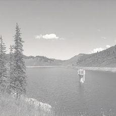
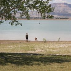
Huntington State Park, State park with warm-water reservoir in Emery County, United States.

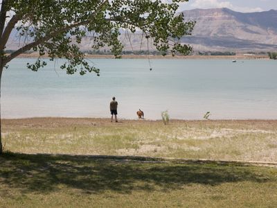
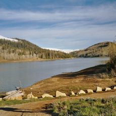
Huntington State Park is a Utah state park in Emery County, built around a reservoir set among cinnamon-colored hills at about 5,840 feet (1,780 m) elevation. The park includes campsites, picnic areas, a boat ramp, and a sandy beach along the water's edge.

The reservoir was built in 1966 by the US Bureau of Reclamation to support irrigation across Emery County's farming land. In the years that followed, the surrounding land was developed into a state park open to the public.

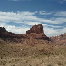
The park takes its name from the Huntington brothers, who explored this part of Utah in the mid-1800s. Today, people gather along the shore to fish, swim, or simply sit while the red and brown hills frame the water on all sides.

The park sits just outside the town of Huntington and is easy to reach by car. Summer days can be very hot on the exposed shore, so arriving early in the morning or later in the afternoon makes outdoor activities more comfortable.

The reservoir holds warmer water than most lakes in the region, which makes it one of the few places in Utah where largemouth bass and bluegill can be caught year-round. In spring and summer, many visitors also come to harvest crawdads, a pastime that has been part of local life here for generations.

The community of curious travelers

AroundUs brings together thousands of curated places, local tips, and hidden gems, enriched daily by 60,000 contributors worldwide.

Start exploring
Location
Inception
1966
GPS coordinates
39.33890,-110.94800
Latest update
March 3, 2026 13:52
Around this place
Cedar Mountain Formation
United States of America

Cedar Mountain Formation

14.9 km
Buckhorn Draw Pictograph Panel
United States of America

Buckhorn Draw Pictograph Panel

32.5 km
USU Eastern Prehistoric Museum
United States of America

USU Eastern Prehistoric Museum

31.4 km
Electric Lake
United States of America

Electric Lake

37.7 km
Bottleneck Peak and Moon
United States of America

Bottleneck Peak and Moon

38.3 km
San Rafael Bridge
United States of America

San Rafael Bridge

37.5 km
Helper Commercial District
United States of America

Helper Commercial District

39.3 km
Spring City School
United States of America

Spring City School

49.4 km
Samuel Singleton House
United States of America

Samuel Singleton House

32.5 km
Ferron Presbyterian Church and Cottage
United States of America

Ferron Presbyterian Church and Cottage

32 km
Mount Pleasant Commercial Historic District (Mount Pleasant, Utah)
United States of America

Mount Pleasant Commercial Historic District (Mount Pleasant, Utah)

49.4 km
Mount Pleasant High School Mechanical Arts Building
United States of America

Mount Pleasant High School Mechanical Arts Building

49.4 km
Castle Dale School
United States of America

Castle Dale School

15.1 km
Alma Staker House
United States of America

Alma Staker House

49 km
Lars Peter Larson House
United States of America

Lars Peter Larson House

8.7 km
Paul C. Christensen House
United States of America

Paul C. Christensen House

15.3 km
Leander Lemmon House
United States of America

Leander Lemmon House

2 km
Cleveland-Lloyd Dinosaur Quarry
United States of America

Cleveland-Lloyd Dinosaur Quarry

22.5 km
Mount Pleasant Carnegie Library
United States of America

Mount Pleasant Carnegie Library

49.3 km
Ole Arilsen House
United States of America

Ole Arilsen House

49 km
The Helper Museum
United States of America

The Helper Museum

39.1 km
Wedge Overlook
United States of America

Wedge Overlook

32.1 km
Little Grand Canyon
United States of America

Little Grand Canyon

32.5 km
Huntington Lake
United States of America

Huntington Lake

834 m
Eccles Canyon
United States of America

Eccles Canyon

42.4 km
Eagle Canyon
United States of America

Eagle Canyon

39.7 km
Price Canyon
United States of America

Price Canyon

41.7 km
Huntington Reservoir
United States of America

Huntington Reservoir

39.3 km
Show the full map
Reviews
Share your experience

No review yet

Discussions
Start a discussion...

No discussion yet

« Huntington State Park - State park with warm-water reservoir in Emery County, United States » is provided by Around Us (aroundus.com). Images and texts are derived from Wikimedia project under a Creative Commons license. You are allowed to copy, distribute, and modify copies of this page, under the conditions set by the license, as long as this note is clearly visible.

Discover hidden gems everywhere you go!

From secret cafés to breathtaking viewpoints, skip the crowded tourist spots and find places that match your style. Our app makes it easy with voice search, smart filtering, route optimization, and insider tips from travelers worldwide. Download now for the complete mobile experience.

Around Us App Screenshot

A unique approach to discovering new places

Le Figaro

All the places worth exploring

France Info

A tailor-made excursion in just a few clicks

20 Minutes

Around Us
Travel Guide & Maps
Download

Send to your phone

QR Code
1

Open the camera app on your mobile.

2

Point at the QR code with your camera. A notification will appear.

3

Tap the notification to open the link.