Enable Location

We need your location to show you interesting places around you

Discover nearby places

Find interesting locations and hidden gems around you

Precise directions

Get accurate directions and distances to places

Your location is never shared with other users. It's only used when you tap the location button.

Cedar Mountain Formation

Log in to your account

Start exploring — it's free

Trusted by 62,832 travelers worldwide

Continue with Google
Continue with Apple
or

We will send you a code to connect

By continuing, you accept our Terms and Conditions and our Privacy Policy

Check your inbox

We've sent a pincode in your inbox. Please enter the code below.

Cedar Mountain Formation

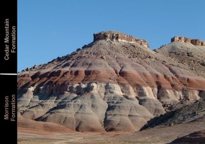
Cedar Mountain Formation, Geological formation in Colorado and Utah, United States

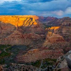
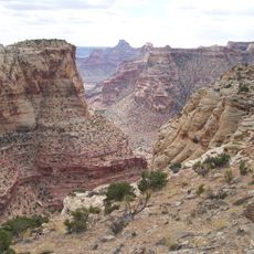
The Cedar Mountain Formation is a geological layer made of conglomerate, sandstone, and mudstone that extends hundreds of meters across the eastern region. These deposits formed during the Early Cretaceous period and hold many traces of ancient life.

The layer was first documented in 1944 by William Lee Stokes and named after Cedar Mountain in northern Emery County. This naming came during his systematic study of Early Cretaceous fossils in the area.

Scientists continuously study this formation to understand Early Cretaceous dinosaur distribution and evolution through numerous fossil discoveries within its layers.

The formations are located in protected areas and require permits for scientific visits. For casual visitors, marked viewpoints and educational trails offer insights into the geology.

The layer preserves two different dinosaur groups in its upper and lower sections, reflecting different living environments and conditions. This distribution lets researchers track how the ancient continent changed over time.

The community of curious travelers

AroundUs brings together thousands of curated places, local tips, and hidden gems, enriched daily by 60,000 contributors worldwide.

Start exploring
Location
Location
GPS coordinates
39.25000,-110.81800
Latest update
December 7, 2025 19:24
Around this place
Huntington State Park
United States of America

Huntington State Park

14.9 km
Buckhorn Draw Pictograph Panel
United States of America

Buckhorn Draw Pictograph Panel

17.7 km
USU Eastern Prehistoric Museum
United States of America

USU Eastern Prehistoric Museum

38.9 km
Electric Lake
United States of America

Electric Lake

52.5 km
Bottleneck Peak and Moon
United States of America

Bottleneck Peak and Moon

23.9 km
Emery LDS Church
United States of America

Emery LDS Church

51.8 km
San Rafael Bridge
United States of America

San Rafael Bridge

22.9 km
Helper Commercial District
United States of America

Helper Commercial District

48.4 km
Spring City School
United States of America

Spring City School

63.4 km
Samuel Singleton House
United States of America

Samuel Singleton House

32.8 km
Ferron Presbyterian Church and Cottage
United States of America

Ferron Presbyterian Church and Cottage

32.9 km
Castle Dale School
United States of America

Castle Dale School

17.6 km
Lars Peter Larson House
United States of America

Lars Peter Larson House

11.1 km
Paul C. Christensen House
United States of America

Paul C. Christensen House

17.8 km
Leander Lemmon House
United States of America

Leander Lemmon House

15.2 km
Cleveland-Lloyd Dinosaur Quarry
United States of America

Cleveland-Lloyd Dinosaur Quarry

13.9 km
The Helper Museum
United States of America

The Helper Museum

48.3 km
Wedge Overlook
United States of America

Wedge Overlook

18.2 km
Little Grand Canyon
United States of America

Little Grand Canyon

18.2 km
Huntington Lake
United States of America

Huntington Lake

15.5 km
Emma Park
United States of America

Emma Park

62.1 km
Swasey's Cabin
United States of America

Swasey's Cabin

46.1 km
Eccles Canyon
United States of America

Eccles Canyon

56.4 km
Price Canyon
United States of America

Price Canyon

51.2 km
Eagle Canyon
United States of America

Eagle Canyon

32.2 km
Huntington Reservoir
United States of America

Huntington Reservoir

54.2 km
Eagle Canyon Bridge
United States of America

Eagle Canyon Bridge

43.6 km
Dutchman Arch
United States of America

Dutchman Arch

42.1 km
Show the full map
« Cedar Mountain Formation - Geological formation in Colorado and Utah, United States » is provided by Around Us (aroundus.com). Images and texts are derived from Wikimedia project under a Creative Commons license. You are allowed to copy, distribute, and modify copies of this page, under the conditions set by the license, as long as this note is clearly visible.

Discover hidden gems everywhere you go!

From secret cafés to breathtaking viewpoints, skip the crowded tourist spots and find places that match your style. Our app makes it easy with voice search, smart filtering, route optimization, and insider tips from travelers worldwide. Download now for the complete mobile experience.

Around Us App Screenshot

A unique approach to discovering new places

Le Figaro

All the places worth exploring

France Info

A tailor-made excursion in just a few clicks

20 Minutes

Around Us
Travel Guide & Maps
Download

Send to your phone

QR Code
1

Open the camera app on your mobile.

2

Point at the QR code with your camera. A notification will appear.

3

Tap the notification to open the link.