Chest opened
+${chestReward.xp} XP
Explorer
NOUVEAU ×${chestReward.collectible.quantity}
tapez pour fermer
Chest locked

Open chests in the app

Around Us is built for your phone — chests unlock when you walk, explore and capture nearby places.

Enable Location

We need your location to show you interesting places around you

Discover nearby places

Find interesting locations and hidden gems around you

Precise directions

Get accurate directions and distances to places

Your location is never shared with other users. It's only used when you tap the location button.

Log in to your account

Start exploring — it's free

Trusted by 72,874 travelers worldwide

Continue with Google
Continue with Apple
or

We will send you a code to connect

By continuing, you accept our Terms and Conditions and our Privacy Policy

Check your inbox

We've sent a pincode in your inbox. Please enter the code below.

Peter Sinks
Discussion Reviews Photo
23.6k Popularity

Peter Sinks, Natural limestone sinkhole in Bear River Mountains, Utah.

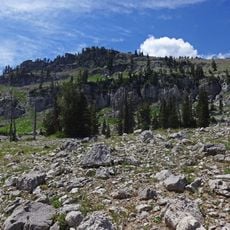
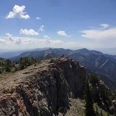
Peter Sinks is a large bowl-shaped depression in the Bear River Mountains in northern Utah. The formation stretches roughly half a mile wide and one mile long at an elevation of about 8,200 feet.

Research student Zane Stephens from Utah State University first systematically documented the extreme temperature patterns at this location. His measurements revealed significant differences between the basin floor and its surrounding edges.

The Utah Climate Center collaborates with Campbell Scientific and Apogee Instruments to maintain monitoring stations for temperature data collection.

Multiple monitoring stations at different elevations throughout the basin help visitors understand how quickly conditions change with height. The best times to visit are during transition seasons when temperature differences are especially noticeable.

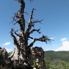
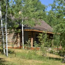
The basin floor remains free of trees while its edges are forested – a reversed pattern compared to normal mountains. This unexpected distribution arises from extreme cold conditions that form at depth and prevent tree growth.

The community of curious travelers

AroundUs brings together thousands of curated places, local tips, and hidden gems, enriched daily by 60,000 contributors worldwide.

Start exploring
Location
GPS coordinates
41.91250,-111.51400
Latest update
December 20, 2025 13:56
Around this place
Maverik Stadium, Utah State
United States of America

Maverik Stadium, Utah State

30.5 km
Logan Canyon
United States of America

Logan Canyon

18.1 km
Bear Lake State Park
United States of America

Bear Lake State Park

11.1 km
Jardine Juniper
United States of America

Jardine Juniper

14.6 km
Bear Lake State Park
United States of America

Bear Lake State Park

29.8 km
Naomi Peak
United States of America

Naomi Peak

13.4 km
Mount Naomi Wilderness
United States of America

Mount Naomi Wilderness

16.2 km
Old Main
United States of America

Old Main

31.4 km
Pickleville Playhouse
United States of America

Pickleville Playhouse

10.3 km
Performance Hall
United States of America

Performance Hall

30.7 km
Crockett House
United States of America

Crockett House

31.7 km
Franklin Historic Properties
United States of America

Franklin Historic Properties

26.4 km
Franklin City Hall
United States of America

Franklin City Hall

26.3 km
John E. Lee House
United States of America

John E. Lee House

28.4 km
Whittier School
United States of America

Whittier School

32.3 km
Hobson-Hill House
United States of America

Hobson-Hill House

24.6 km
Family Life Building
United States of America

Family Life Building

31.2 km
Anna Nielsen Scofield House
United States of America

Anna Nielsen Scofield House

17.1 km
Richmond Carnegie Library
United States of America

Richmond Carnegie Library

24.5 km
Tony Grove Ranger Station Historic District
United States of America

Tony Grove Ranger Station Historic District

5.3 km
Morgan A. and Clarissa R. Knapp House
United States of America

Morgan A. and Clarissa R. Knapp House

24.1 km
Richmond Tithing Office
United States of America

Richmond Tithing Office

24.3 km
Smithfield Tithing Office
United States of America

Smithfield Tithing Office

27.7 km
Bell-Johnson House
United States of America

Bell-Johnson House

23.8 km
Samuel and Lana Ewing House
United States of America

Samuel and Lana Ewing House

27.6 km
Richmond Relief Society Hall
United States of America

Richmond Relief Society Hall

24.4 km
Lewiston Community Building
United States of America

Lewiston Community Building

29.1 km
Rendezvous Beach
United States of America

Rendezvous Beach

15.9 km
Show the full map
Reviews
Share your experience

No review yet

Discussions
Start a discussion...

No discussion yet

« Peter Sinks - Natural limestone sinkhole in Bear River Mountains, Utah » is provided by Around Us (aroundus.com). Images and texts are derived from Wikimedia project under a Creative Commons license. You are allowed to copy, distribute, and modify copies of this page, under the conditions set by the license, as long as this note is clearly visible.

Discover hidden gems everywhere you go!

From secret cafés to breathtaking viewpoints, skip the crowded tourist spots and find places that match your style. Our app makes it easy with voice search, smart filtering, route optimization, and insider tips from travelers worldwide. Download now for the complete mobile experience.

Around Us App Screenshot

A unique approach to discovering new places

Le Figaro

All the places worth exploring

France Info

A tailor-made excursion in just a few clicks

20 Minutes

Around Us
Travel Guide & Maps
Download

Send to your phone

QR Code
1

Open the camera app on your mobile.

2

Point at the QR code with your camera. A notification will appear.

3

Tap the notification to open the link.