Medicine Bow Peak

Log in to your account

AroundUs is a community-driven map of interesting places, built by curious explorers like you. It grows with every review, story, and photo you share.
Connect to save your favorite spots, contribute locations, and create personalized routes.
By continuing, you accept our Terms and Conditions and our Privacy Policy
Add to collection
Map
Suggest a change
Share

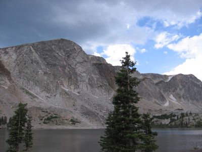
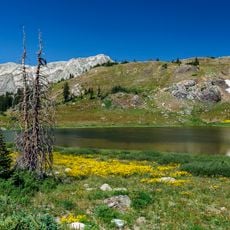
Medicine Bow Peak, Mountain summit in Snowy Range, Wyoming.

Medicine Bow Peak is the highest summit in the Snowy Range of southern Wyoming, rising 12,014 feet above the surrounding landscape. The mountain is surrounded by alpine lakes and accessible through multiple established hiking trails that wind through forest and alpine terrain.

The peak became the site of a United Airlines airplane crash in 1955 that killed all people aboard. A memorial was installed decades later to honor those lost in this tragedy.

The mountain held significance as a travel route for Northern Arapahoe and Lakota peoples who moved through these high country passes. Walking the trails today, you can sense the long history of movement through this landscape.

Access to the peak is available from four different lake trailheads scattered throughout the range, offering options for various hiking abilities. The best time to visit is late summer and early fall when snow has melted and trails are most passable.

The summit contains ancient quartzite rock formations from the Proterozoic Era that stand out from surrounding geological features. Above the timberline, geometric soil patterns are visible where repeated freezing and thawing has shaped the ground into polygonal designs.

Location: Wyoming

GPS coordinates: 41.36025,-106.31729

Latest update: December 10, 2025 15:59

Photos
Around this place
Show the full map
Wyoming Territorial Prison State Historic Site
United States of America

Wyoming Territorial Prison State Historic Site

59.4 km
Fort Sanders
United States of America

Fort Sanders

61 km
Elk Mountain
United States of America

Elk Mountain

35 km
Wyoming Infrared Observatory
United States of America

Wyoming Infrared Observatory

40.9 km
Sand Creek
United States of America

Sand Creek

51.6 km
Hutton Lake Wildlife Refuge
United States of America

Hutton Lake Wildlife Refuge

54 km
Snow Train Rolling Stock
United States of America

Snow Train Rolling Stock

60.6 km
Bath Ranch
United States of America

Bath Ranch

41.3 km
Vee Bar Ranch Lodge
United States of America

Vee Bar Ranch Lodge

26.5 km
Northgate Canyon
United States of America

Northgate Canyon

40.2 km
St. Matthew's Cathedral
United States of America

St. Matthew's Cathedral

60.9 km
Willis House
United States of America

Willis House

43.4 km
Bath Row
United States of America

Bath Row

61.1 km
Ryan Ranch
United States of America

Ryan Ranch

33.4 km
First National Bank of Rock River
United States of America

First National Bank of Rock River

51.1 km
Laramie Downtown Historic District
United States of America

Laramie Downtown Historic District

60.7 km
DMJ Pick Bridge
United States of America

DMJ Pick Bridge

51.1 km
Woods Landing Dance Hall
United States of America

Woods Landing Dance Hall

37.8 km
DML Butler Bridge
United States of America

DML Butler Bridge

29.3 km
Brooklyn Lodge
United States of America

Brooklyn Lodge

7.1 km
DFU Elk Mountain Bridge
United States of America

DFU Elk Mountain Bridge

37.2 km
Charles E. Blair House
United States of America

Charles E. Blair House

61 km
DOE Bridge over Laramie River
United States of America

DOE Bridge over Laramie River

60.9 km
Lincoln School
United States of America

Lincoln School

60.2 km
Centennial Work Center
United States of America

Centennial Work Center

14.6 km
Laramie Railroad Depot
United States of America

Laramie Railroad Depot

60.5 km
Wyo Theater
United States of America

Wyo Theater

61 km
Snowy Range Scenic Byway
United States of America

Snowy Range Scenic Byway

2.1 km
Show the full map
Reviews

Visited this place? Tap the stars to rate it and share your experience / photos with the community! Try now! You can cancel it anytime.

« Medicine Bow Peak - Mountain summit in Snowy Range, Wyoming » is provided by Around Us (aroundus.com). Images and texts are derived from Wikimedia project under a Creative Commons license. You are allowed to copy, distribute, and modify copies of this page, under the conditions set by the license, as long as this note is clearly visible.

Discover hidden gems everywhere you go!

From secret cafés to breathtaking viewpoints, skip the crowded tourist spots and find places that match your style. Our app makes it easy with voice search, smart filtering, route optimization, and insider tips from travelers worldwide. Download now for the complete mobile experience.

Around Us App Screenshot

A unique approach to discovering new places

Le Figaro

All the places worth exploring

France Info

A tailor-made excursion in just a few clicks

20 Minutes