Enable Location

We need your location to show you interesting places around you

Discover nearby places

Find interesting locations and hidden gems around you

Precise directions

Get accurate directions and distances to places

Your location is never shared with other users. It's only used when you tap the location button.

Snowy Range Scenic Byway

Log in to your account

Start exploring — it's free

Trusted by 61,619 travelers worldwide

Continue with Google
Continue with Apple
or

We will send you a code to connect

By continuing, you accept our Terms and Conditions and our Privacy Policy

Check your inbox

We've sent a pincode in your inbox. Please enter the code below.

Snowy Range Scenic Byway

Snowy Range Scenic Byway, Scenic route in Carbon County, Wyoming

Description

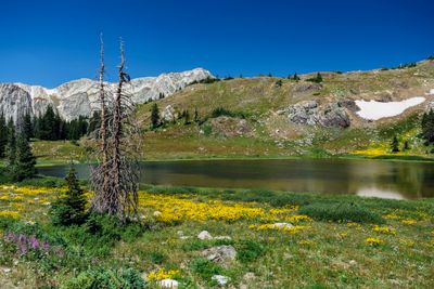
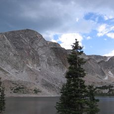
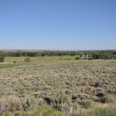
The Snowy Range Scenic Byway is a scenic route through Medicine Bow National Forest that connects Laramie and Encampment, spanning approximately 29 miles through the mountains. The drive passes mountain peaks and glacial lakes as the road winds through the forest at varying elevations.

History

Native American tribes including the Northern Arapaho and Oglala Sioux gathered mountain mahogany wood from this area long ago for making bows and tools. The region held importance as a resource and hunting ground for these communities over many centuries.

Culture

Information signs along the route explain Rocky Mountain ecosystems, wildlife habitats, and geological formations found in the area. These details help visitors understand the landscape and how nature works here.

Practical

The drive climbs to higher elevations where temperatures drop and weather can change quickly throughout the day. The road typically closes from November through late May due to heavy snow, so check current conditions before planning your trip.

Did you know?

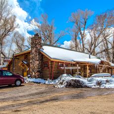
Near Saratoga at the end of the route, mineral-rich hot springs bubble up from the ground and remain open to the public. Visitors can soak in these natural thermal pools at no cost, making them a refreshing stop after the drive.

Location
GPS coordinates
41.34188,-106.31459
Latest update
December 6, 2025 19:10

AroundUs brings together thousands of curated places, local tips, and hidden gems, enriched daily by 60,000 contributors worldwide. Discover all places nearby (Carbon County).

Natural wonders and historic sites in Wyoming

Wyoming preserves geological sites that include thermal springs, canyons, and rock formations. The state protects historic locations such as forts, rock art, and dinosaur tracks. Devils Tower rises 1,267 feet (386 meters) above the terrain and represents a significant geological formation. Fossil...

Around this place
Medicine Bow Peak
United States of America

Medicine Bow Peak

2.1 km
Wyoming Territorial Prison State Historic Site
United States of America

Wyoming Territorial Prison State Historic Site

59 km
Fort Sanders
United States of America

Fort Sanders

60.5 km
Elk Mountain
United States of America

Elk Mountain

36.9 km
Wyoming Infrared Observatory
United States of America

Wyoming Infrared Observatory

39.3 km
Sand Creek
United States of America

Sand Creek

50.8 km
Hutton Lake Wildlife Refuge
United States of America

Hutton Lake Wildlife Refuge

53.1 km
Snow Train Rolling Stock
United States of America

Snow Train Rolling Stock

60.2 km
Bath Ranch
United States of America

Bath Ranch

41.4 km
Vee Bar Ranch Lodge
United States of America

Vee Bar Ranch Lodge

25.8 km
United States of America

Northgate Canyon

38.2 km
St. Matthew's Cathedral
United States of America

St. Matthew's Cathedral

60.5 km
Willis House
United States of America

Willis House

42.9 km
Bath Row
United States of America

Bath Row

60.7 km
Saint Paul's United Church of Christ
United States of America

Saint Paul's United Church of Christ

60.7 km
Ryan Ranch
United States of America

Ryan Ranch

33.8 km
First National Bank of Rock River
United States of America

First National Bank of Rock River

52.7 km
Laramie Downtown Historic District
United States of America

Laramie Downtown Historic District

60.4 km
DMJ Pick Bridge
United States of America

DMJ Pick Bridge

52.1 km
Woods Landing Dance Hall
United States of America

Woods Landing Dance Hall

36.1 km
DML Butler Bridge
United States of America

DML Butler Bridge

28.8 km
Brooklyn Lodge
United States of America

Brooklyn Lodge

7 km
DFU Elk Mountain Bridge
United States of America

DFU Elk Mountain Bridge

39.3 km
Charles E. Blair House
United States of America

Charles E. Blair House

60.6 km
Lincoln School
United States of America

Lincoln School

59.9 km
Centennial Work Center
United States of America

Centennial Work Center

13.7 km
Laramie Railroad Depot
United States of America

Laramie Railroad Depot

60.2 km
Wyo Theater
United States of America

Wyo Theater

60.6 km
Show the full map
« Snowy Range Scenic Byway - Scenic route in Carbon County, Wyoming » is provided by Around Us (aroundus.com). Images and texts are derived from Wikimedia project under a Creative Commons license. You are allowed to copy, distribute, and modify copies of this page, under the conditions set by the license, as long as this note is clearly visible.

Discover hidden gems everywhere you go!

From secret cafés to breathtaking viewpoints, skip the crowded tourist spots and find places that match your style. Our app makes it easy with voice search, smart filtering, route optimization, and insider tips from travelers worldwide. Download now for the complete mobile experience.

Around Us App Screenshot

A unique approach to discovering new places

Le Figaro

All the places worth exploring

France Info

A tailor-made excursion in just a few clicks

20 Minutes

Around Us
Travel Guide & Maps
Download

Send to your phone

QR Code
1

Open the camera app on your mobile.

2

Point at the QR code with your camera. A notification will appear.

3

Tap the notification to open the link.