Chest opened
+${chestReward.xp} XP
Explorer
NOUVEAU ×${chestReward.collectible.quantity}
tapez pour fermer
Chest locked

Open chests in the app

Around Us is built for your phone — chests unlock when you walk, explore and capture nearby places.

Enable Location

We need your location to show you interesting places around you

Discover nearby places

Find interesting locations and hidden gems around you

Precise directions

Get accurate directions and distances to places

Your location is never shared with other users. It's only used when you tap the location button.

Indian Creek

Log in to your account

Start exploring — it's free

Trusted by 72,932 travelers worldwide

Continue with Google
Continue with Apple
or

We will send you a code to connect

By continuing, you accept our Terms and Conditions and our Privacy Policy

Check your inbox

We've sent a pincode in your inbox. Please enter the code below.

Indian Creek
Discussion Reviews 1 Photos
2k Popularity

Indian Creek, Natural watercourse in Canyon County, United States.

Indian Creek is a natural watercourse that flows across three counties in Idaho: Canyon County, Elmore County, and Ada County. The stream moves through varied terrain, creating a continuous water corridor that connects different parts of the region.

The creek has followed its natural course through Idaho's landscape for millions of years, shaped by geological processes during the Quaternary period. Its pathway and form were created through erosion and water movement over extended time scales.

The creek served as a vital water source for Native American communities who established seasonal settlements along its banks for sustenance and daily life.

You can access the area at several points in Canyon County where parking areas and trail markers show the way to water access spots. The best time to visit depends on the season and how the water conditions change throughout the year.

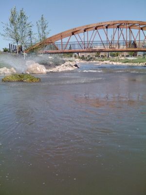
The creek displays dramatic seasonal changes in water levels driven by spring snowmelt, which creates temporary rapids and rushing flows. By late summer, the water calms down into gentler currents that make the creek quite different from its springtime character.

The community of curious travelers

AroundUs brings together thousands of curated places, local tips, and hidden gems, enriched daily by 60,000 contributors worldwide.

Start exploring
Location
Location
Location
Elevation above the sea
716 m
GPS coordinates
43.67738,-116.70542
Latest update
December 14, 2025 09:43
Around this place
Idaho Center
United States of America

Idaho Center

17.7 km
Deer Flat National Wildlife Refuge
United States of America

Deer Flat National Wildlife Refuge

14.5 km
Lakeview Water Park
United States of America

Lakeview Water Park

16.2 km
Simplot Stadium
United States of America

Simplot Stadium

3.8 km
The Haunted World
United States of America

The Haunted World

10.6 km
Boise River and Canal Bridge
United States of America

Boise River and Canal Bridge

2 km
Nampa Historic District
United States of America

Nampa Historic District

16.2 km
Caldwell Historic District
United States of America

Caldwell Historic District

1.9 km
Nampa Bowling
United States of America

Nampa Bowling

13.3 km
Farmers and Merchants Bank
United States of America

Farmers and Merchants Bank

16 km
A. K. Steunenberg House
United States of America

A. K. Steunenberg House

2 km
St. Mary's Catholic Church
United States of America

St. Mary's Catholic Church

1.8 km
Blatchley Hall
United States of America

Blatchley Hall

3.7 km
Henry W. and Ida Frost Dorman House
United States of America

Henry W. and Ida Frost Dorman House

2.6 km
Nampa Department Store
United States of America

Nampa Department Store

15.6 km
Nampa and Meridian Irrigation District Office
United States of America

Nampa and Meridian Irrigation District Office

16.5 km
Caldwell Carnegie Library
United States of America

Caldwell Carnegie Library

2.3 km
F. F. Beale House
United States of America

F. F. Beale House

3.1 km
Nampa Presbyterian Church
United States of America

Nampa Presbyterian Church

16.4 km
Jacob P. Lockman House
United States of America

Jacob P. Lockman House

15.7 km
John C. Rice House
United States of America

John C. Rice House

2.9 km
Thomas K. Little House
United States of America

Thomas K. Little House

1.9 km
Nampa American Legion Chateau
United States of America

Nampa American Legion Chateau

16.5 km
H. Orton Wiley House
United States of America

H. Orton Wiley House

16.9 km
Sterry Hall
United States of America

Sterry Hall

3.5 km
Carrie Adell Strahorn Memorial Library
United States of America

Carrie Adell Strahorn Memorial Library

3.6 km
MacMillan Chapel
United States of America

MacMillan Chapel

15.5 km
Star Camp
United States of America

Star Camp

17.2 km
Show the full map
Reviews
Share your experience

No review yet

Discussions
Start a discussion...

No discussion yet

« Indian Creek - Natural watercourse in Canyon County, United States » is provided by Around Us (aroundus.com). Images and texts are derived from Wikimedia project under a Creative Commons license. You are allowed to copy, distribute, and modify copies of this page, under the conditions set by the license, as long as this note is clearly visible.

Discover hidden gems everywhere you go!

From secret cafés to breathtaking viewpoints, skip the crowded tourist spots and find places that match your style. Our app makes it easy with voice search, smart filtering, route optimization, and insider tips from travelers worldwide. Download now for the complete mobile experience.

Around Us App Screenshot

A unique approach to discovering new places

Le Figaro

All the places worth exploring

France Info

A tailor-made excursion in just a few clicks

20 Minutes

Around Us
Travel Guide & Maps
Download

Send to your phone

QR Code
1

Open the camera app on your mobile.

2

Point at the QR code with your camera. A notification will appear.

3

Tap the notification to open the link.