Enable Location

We need your location to show you interesting places around you

Discover nearby places

Find interesting locations and hidden gems around you

Precise directions

Get accurate directions and distances to places

Your location is never shared with other users. It's only used when you tap the location button.

Elmore County

Log in to your account

Start exploring — it's free

Trusted by 62,888 travelers worldwide

Continue with Google
Continue with Apple
or

We will send you a code to connect

By continuing, you accept our Terms and Conditions and our Privacy Policy

Check your inbox

We've sent a pincode in your inbox. Please enter the code below.

Discussion Reviews 1 Photos
13.4k Popularity

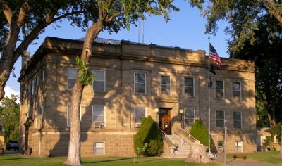
Elmore County, Administrative county in southern Idaho, United States

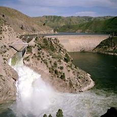
Elmore County is an administrative county in southern Idaho encompassing diverse terrain with mountains, rivers, and open spaces. Mountain Home serves as the county seat and administrative hub for the region.

The county was established in 1889 as an administrative division in Idaho's growth period. The arrival of the military base in the 20th century significantly changed the area's development and population growth.

The Mountain Home Air Force Base shapes local life, bringing military families into the community and influencing local businesses and schools. Many residents have connections to the base, making military service part of the town's everyday fabric.

Visitors can access government services at offices in Mountain Home, including property tax records and vehicle registration. Main administrative services are available during business hours at the county seat.

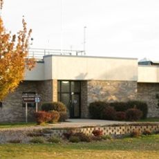
Glenns Ferry, a section within the county, has a branch motor vehicle office that opens on specific days for local service. This smaller facility helps residents in more remote areas who cannot always travel to the county seat.

The community of curious travelers

AroundUs brings together thousands of curated places, local tips, and hidden gems, enriched daily by 60,000 contributors worldwide.

Start exploring
Location
Inception
February 7, 1889
Capital city
Mountain Home
Shares border with
Boise County, Ada County, Custer County, Blaine County, Camas County, Gooding County, Twin Falls County, Owyhee County
GPS coordinates
43.34000,-115.47000
Latest update
December 7, 2025 20:40
Around this place
Albertsons Stadium
United States of America

Albertsons Stadium

65.5 km
Idaho State Capitol
United States of America

Idaho State Capitol

66.6 km
Old Idaho State Penitentiary
United States of America

Old Idaho State Penitentiary

63.1 km
Sawtooth National Recreation Area
United States of America

Sawtooth National Recreation Area

86.4 km
Bruneau Dunes State Park
United States of America

Bruneau Dunes State Park

52.3 km
Sawtooth Wilderness
United States of America

Sawtooth Wilderness

80.3 km
The Egyptian Theatre
United States of America

The Egyptian Theatre

66.5 km
Julia Davis Park
United States of America

Julia Davis Park

66.2 km
Arrowrock Dam
United States of America

Arrowrock Dam

46.3 km
Zions Bank Idaho Headquarters
United States of America

Zions Bank Idaho Headquarters

66.8 km
Anne Frank Human Rights Memorial
United States of America

Anne Frank Human Rights Memorial

66.8 km
Morley Nelson Snake River Birds of Prey National Conservation Area
United States of America

Morley Nelson Snake River Birds of Prey National Conservation Area

59.5 km
Three Island Crossing State Park
United States of America

Three Island Crossing State Park

46.1 km
Cathedral of St. John the Evangelist
United States of America

Cathedral of St. John the Evangelist

66.7 km
Boise Art Museum
United States of America

Boise Art Museum

66.6 km
Lucky Peak State Park
United States of America

Lucky Peak State Park

52.2 km
Ahavath Beth Israel
United States of America

Ahavath Beth Israel

68.1 km
Lucky Peak Lake
United States of America

Lucky Peak Lake

50.7 km
Jack's Urban Meeting Place
United States of America

Jack's Urban Meeting Place

67 km
Crater Rings
United States of America

Crater Rings

35.7 km
Idaho Botanical Garden
United States of America

Idaho Botanical Garden

63 km
Ann Morrison Park
United States of America

Ann Morrison Park

67.7 km
Old Idaho Penitentiary Site
United States of America

Old Idaho Penitentiary Site

63.1 km
Assay Office
United States of America

Assay Office

66 km
Camel's Back Park
United States of America

Camel's Back Park

67.6 km
St. Alphonsus Hospital
United States of America

St. Alphonsus Hospital

66.3 km
U.S. Bank Building
United States of America

U.S. Bank Building

66.7 km
National Weather Service Boise, Idaho
United States of America

National Weather Service Boise, Idaho

65 km
Show the full map
Administrative divisions
« Elmore County - Administrative county in southern Idaho, United States » is provided by Around Us (aroundus.com). Images and texts are derived from Wikimedia project under a Creative Commons license. You are allowed to copy, distribute, and modify copies of this page, under the conditions set by the license, as long as this note is clearly visible.

Discover hidden gems everywhere you go!

From secret cafés to breathtaking viewpoints, skip the crowded tourist spots and find places that match your style. Our app makes it easy with voice search, smart filtering, route optimization, and insider tips from travelers worldwide. Download now for the complete mobile experience.

Around Us App Screenshot

A unique approach to discovering new places

Le Figaro

All the places worth exploring

France Info

A tailor-made excursion in just a few clicks

20 Minutes

Around Us
Travel Guide & Maps
Download

Send to your phone

QR Code
1

Open the camera app on your mobile.

2

Point at the QR code with your camera. A notification will appear.

3

Tap the notification to open the link.