Enable Location

We need your location to show you interesting places around you

Discover nearby places

Find interesting locations and hidden gems around you

Precise directions

Get accurate directions and distances to places

Your location is never shared with other users. It's only used when you tap the location button.

Arrowrock Dam

Log in to your account

Start exploring — it's free

Trusted by 66,363 travelers worldwide

Continue with Google
Continue with Apple
or

We will send you a code to connect

By continuing, you accept our Terms and Conditions and our Privacy Policy

Check your inbox

We've sent a pincode in your inbox. Please enter the code below.

Discussion Reviews 1 Photos
6.9k Popularity

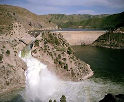
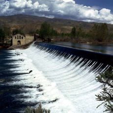
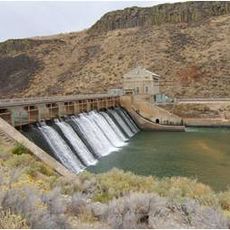
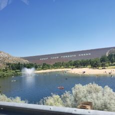
Arrowrock Dam, Arch dam in Elmore County, United States.

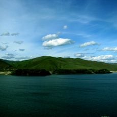
Arrowrock Dam is a concrete arch dam crossing the Boise River in Elmore and Boise counties, Idaho, listed on the National Register of Historic Places and recognized as a Historic Civil Engineering Landmark. The dam holds back a large reservoir that has long supplied water for irrigation across the surrounding agricultural areas.

Construction began in the early 1910s as part of a federal reclamation program aimed at bringing water to dry western lands, and the dam was finished in 1915. At the time it was completed, it was the tallest arch dam ever built.

The dam sits in a dry high desert landscape where farming would be nearly impossible without water storage. The reservoir it holds back has shaped the way people in the surrounding valleys grow food and manage their land.

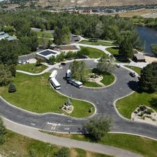
The dam is reached by rural roads outside Boise, and conditions on those roads can change quickly with rain or snow, so dry weather is the best time to visit. Sturdy footwear is a good idea since the ground around the viewing area is uneven.

During construction, temperature sensors were embedded directly into the concrete to track how the material cured, which was an early and forward-looking approach to monitoring a large structure. The workers' camp built on site also had running water and electric lighting, which was far from standard on remote construction sites at that time.

The community of curious travelers

AroundUs brings together thousands of curated places, local tips, and hidden gems, enriched daily by 60,000 contributors worldwide.

Start exploring
Location
Location
GPS coordinates
43.59560,-115.92200
Latest update
March 3, 2026 10:10
Around this place
Old Idaho State Penitentiary
United States of America

Old Idaho State Penitentiary

19.4 km
Lucky Peak State Park
United States of America

Lucky Peak State Park

13 km
Lucky Peak Lake
United States of America

Lucky Peak Lake

12.5 km
Idaho Botanical Garden
United States of America

Idaho Botanical Garden

19.3 km
Old Idaho Penitentiary Site
United States of America

Old Idaho Penitentiary Site

19.4 km
MK Nature Center
United States of America

MK Nature Center

21.2 km
Barber Dam
United States of America

Barber Dam

16.6 km
Warm Springs Avenue Historic District
United States of America

Warm Springs Avenue Historic District

20.9 km
Christ Chapel
United States of America

Christ Chapel

21.9 km
Diversion Dam and Deer Flat Embankments
United States of America

Diversion Dam and Deer Flat Embankments

15.2 km
Barber Park
United States of America

Barber Park

17.7 km
Garfield School
United States of America

Garfield School

21.8 km
Moore–Cunningham House
United States of America

Moore–Cunningham House

20.9 km
United States of America

Artesian Water Co. Pumphouse and Wells

19.4 km
Idaho National Guard Armory
United States of America

Idaho National Guard Armory

21.2 km
Bishop Funsten House
United States of America

Bishop Funsten House

19.3 km
Nathan Smith House
United States of America

Nathan Smith House

21.9 km
Rosedale Odd Fellows Temple
United States of America

Rosedale Odd Fellows Temple

21.9 km
Fred Reiger Houses
United States of America

Fred Reiger Houses

21.8 km
Roosevelt School
United States of America

Roosevelt School

21 km
Reclamation Service Boise Project Office
United States of America

Reclamation Service Boise Project Office

21.9 km
C. C. Cavanah House
United States of America

C. C. Cavanah House

21.9 km
John A. O'Farrell House
United States of America

John A. O'Farrell House

21.8 km
H. C. Burnett House
United States of America

H. C. Burnett House

19.5 km
Joseph Chitwood House
United States of America

Joseph Chitwood House

21.9 km
Boise City Natatorium
United States of America

Boise City Natatorium

20.4 km
Black Cliffs Rock Climbing
United States of America

Black Cliffs Rock Climbing

15.2 km
Sandy Point Beach
United States of America

Sandy Point Beach

13.1 km
Show the full map
Reviews
Share your experience

No review yet

Discussions
Start a discussion...

No discussion yet

« Arrowrock Dam - Arch dam in Elmore County, United States » is provided by Around Us (aroundus.com). Images and texts are derived from Wikimedia project under a Creative Commons license. You are allowed to copy, distribute, and modify copies of this page, under the conditions set by the license, as long as this note is clearly visible.

Discover hidden gems everywhere you go!

From secret cafés to breathtaking viewpoints, skip the crowded tourist spots and find places that match your style. Our app makes it easy with voice search, smart filtering, route optimization, and insider tips from travelers worldwide. Download now for the complete mobile experience.

Around Us App Screenshot

A unique approach to discovering new places

Le Figaro

All the places worth exploring

France Info

A tailor-made excursion in just a few clicks

20 Minutes

Around Us
Travel Guide & Maps
Download

Send to your phone

QR Code
1

Open the camera app on your mobile.

2

Point at the QR code with your camera. A notification will appear.

3

Tap the notification to open the link.