Hungry Horse Dam

Log in to your account

AroundUs is a community-driven map of interesting places, built by curious explorers like you. It grows with every review, story, and photo you share.
Connect to save your favorite spots, contribute locations, and create personalized routes.
By continuing, you accept our Terms and Conditions and our Privacy Policy
Add to collection
Map
Suggest a change
Share

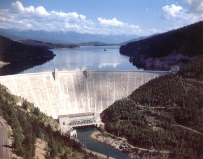
Hungry Horse Dam, Concrete arch dam in Flathead County, United States.

The Hungry Horse Dam extends 645 meters across the South Fork Flathead River, featuring four Francis turbines that generate hydroelectric power for Montana communities.

Construction began in 1948 with workers establishing a complete settlement including housing, schools, stores, and hospitals to support the massive building project.

The name derives from two freight horses that survived a harsh winter storm in 1900, when they wandered away and returned severely undernourished.
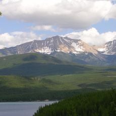
The facility produces over one billion kilowatt hours of electricity annually, supporting energy needs in Kalispell, Whitefish, and Columbia Falls regions.

The morning glory spillway stands as the highest structure of its type worldwide, allowing water to descend 490 feet through its vertical shaft.

Location: Flathead County

Inception: 1948

Length: 645 m

GPS coordinates: 48.34167,-114.01417

Latest update: December 5, 2025 16:14

Unusual Montana: natural sites, historic landmarks, and craft distilleries

Montana hosts natural and historic sites ranging from the limestone gorges of Bighorn Canyon, where red cliffs rise over 300 meters, to the Makoshika badlands dotted with dinosaur fossils. Visitors explore the boiling River near Gardiner, where thermal springs blend with the cold waters of the Gardner River, or cross the Kootenai suspension bridge that spans the river for 64 meters. The state also preserves traces of its past with the Pompeys Pillar, a sandstone formation bearing William Clark's signature from 1806, and the Gates of the Mountains, a canyon named by Meriwether Lewis during the 1805 expedition. From craft distilleries like Glacier Distilling Company in Coram, old railway infrastructures converted into accommodations, to artistic installations such as the Blue Horses in Three Forks, Montana offers a variety of discoveries for travelers exploring its regions.

Around this place
Show the full map
Bad Rock Canyon
United States of America

Bad Rock Canyon

8.5 km
Charles E. Conrad Mansion
United States of America

Charles E. Conrad Mansion

26.7 km
Belton Chalets
United States of America

Belton Chalets

17.5 km
South Fork Flathead River
United States of America

South Fork Flathead River

56.3 km
Lockridge Medical Clinic
United States of America

Lockridge Medical Clinic

25 km
Apgar Fire Lookout
United States of America

Apgar Fire Lookout

19.6 km
Stanton Glacier
United States of America

Stanton Glacier

17.7 km
Headquarters Historic District
United States of America

Headquarters Historic District

17.9 km
Soldiers' Home Historic District
United States of America

Soldiers' Home Historic District

14.6 km
International Larix Arboretum
United States of America

International Larix Arboretum

5.7 km
Loneman Fire Lookout
United States of America

Loneman Fire Lookout

24.4 km
West Entrance Station
United States of America

West Entrance Station

18.4 km
Nyack Ranger Station Historic District
United States of America

Nyack Ranger Station Historic District

19.5 km
First Presbyterian Church of Whitefish
United States of America

First Presbyterian Church of Whitefish

24.9 km
Grant Glacier
United States of America

Grant Glacier

19.5 km
Amazing Fun Center
United States of America

Amazing Fun Center

9.5 km
Ray E. Taylor House
United States of America

Ray E. Taylor House

24.9 km
Bruyer Granary
United States of America

Bruyer Granary

25.1 km
Glacier Distilling Company - The Whiskey Barn
United States of America

Glacier Distilling Company - The Whiskey Barn

9.3 km
Billsborough House
United States of America

Billsborough House

26.4 km
Woodland Water Park
United States of America

Woodland Water Park

26.3 km
Fish Creek Bay Boathouse
United States of America

Fish Creek Bay Boathouse

23.5 km
Pine Grove Pond Fishing Access Sign
United States of America

Pine Grove Pond Fishing Access Sign

22.7 km
Wanda Hollensteiner Art Gallery
United States of America

Wanda Hollensteiner Art Gallery

26.2 km
Apgar Visitor Center
United States of America

Apgar Visitor Center

20.3 km
Fish Creek Campground Amphitheater
United States of America

Fish Creek Campground Amphitheater

23.2 km
Apgar Campground Amphitheater
United States of America

Apgar Campground Amphitheater

21 km
Echo Lake Cosway entrance
United States of America

Echo Lake Cosway entrance

23.4 km
Show the full map

Reviews

Visited this place? Tap the stars to rate it and share your experience / photos with the community! Try now! You can cancel it anytime.

« Hungry Horse Dam - Concrete arch dam in Flathead County, United States » is provided by Around Us (aroundus.com). Images and texts are derived from Wikimedia project under a Creative Commons license. You are allowed to copy, distribute, and modify copies of this page, under the conditions set by the license, as long as this note is clearly visible.

Discover hidden gems everywhere you go!

From secret cafés to breathtaking viewpoints, skip the crowded tourist spots and find places that match your style. Our app makes it easy with voice search, smart filtering, route optimization, and insider tips from travelers worldwide. Download now for the complete mobile experience.

Around Us App Screenshot

A unique approach to discovering new places

Le Figaro

All the places worth exploring

France Info

A tailor-made excursion in just a few clicks

20 Minutes