Chest opened
+${chestReward.xp} XP
Explorer
NOUVEAU ×${chestReward.collectible.quantity}
tapez pour fermer
Chest locked

Open chests in the app

Around Us is built for your phone — chests unlock when you walk, explore and capture nearby places.

Enable Location

We need your location to show you interesting places around you

Discover nearby places

Find interesting locations and hidden gems around you

Precise directions

Get accurate directions and distances to places

Your location is never shared with other users. It's only used when you tap the location button.

Log in to your account

Start exploring — it's free

Trusted by 72,969 travelers worldwide

Continue with Google
Continue with Apple
or

We will send you a code to connect

By continuing, you accept our Terms and Conditions and our Privacy Policy

Check your inbox

We've sent a pincode in your inbox. Please enter the code below.

Four Dances Natural Area
Discussion Reviews Photo
1.5k Popularity

Four Dances Natural Area, Natural recreation area in Billings, Montana.

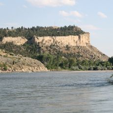
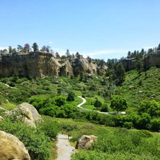
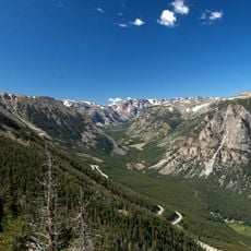
Four Dances Natural Area is an undeveloped natural zone spanning 765 acres with steep cliffs dropping 200 to 800 feet to the Yellowstone River below. The land contains hiking trails, wildlife observation areas, and educational signage throughout its terrain.

The area was acquired by the Bureau of Land Management in 1999 as a conservation effort. This initiative came through partnership between federal management, private landowners, and the Yellowstone River Parks Association.

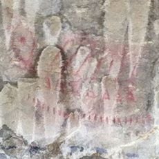
The Crow Nation called this area Annishi Shopash, connected to spiritual visions that Chief Four Dances experienced during a fasting ritual here in the 1830s. This heritage remains woven into the local understanding of the land's importance.

The main entrance sits about 1.5 miles south on Coburn Road from central Billings. Trails vary in difficulty, and visitors should prepare for changing weather and potential wildlife encounters along the paths.

The site displays three distinct ecological zones stacked vertically: sagebrush lands at the top, grasslands on the slopes, and ponderosa pine forest at lower elevations. This layering happens naturally due to exposure and elevation changes along the cliffs.

The community of curious travelers

AroundUs brings together thousands of curated places, local tips, and hidden gems, enriched daily by 60,000 contributors worldwide.

Start exploring
Location
GPS coordinates
45.76500,-108.45700
Latest update
December 14, 2025 14:20
Around this place
Lewis and Clark National Historic Trail
United States of America

Lewis and Clark National Historic Trail

43.7 km
Pictograph Cave
United States of America

Pictograph Cave

3.2 km
First Interstate Center
United States of America

First Interstate Center

4.7 km
Rimrocks
United States of America

Rimrocks

10.4 km
Moss Mansion
United States of America

Moss Mansion

4.9 km
ZooMontana
United States of America

ZooMontana

13.4 km
Chief Plenty Coups State Park and Home
United States of America

Chief Plenty Coups State Park and Home

38.4 km
Rimrock Auto Arena at MetraPark
United States of America

Rimrock Auto Arena at MetraPark

4.2 km
Lake Elmo State Park
United States of America

Lake Elmo State Park

8.4 km
Dude Rancher Lodge
United States of America

Dude Rancher Lodge

6.7 km
Northern Hotel
United States of America

Northern Hotel

4.2 km
Western Heritage Center
United States of America

Western Heritage Center

4.2 km
St. Patrick's Co-Cathedral
United States of America

St. Patrick's Co-Cathedral

4.6 km
Alberta Bair Theater
United States of America

Alberta Bair Theater

4.4 km
Pictograph Cave State Park
United States of America

Pictograph Cave State Park

3.6 km
The Reef
United States of America

The Reef

11.8 km
Prescott Commons
United States of America

Prescott Commons

8.2 km
Masonic Temple
United States of America

Masonic Temple

4.4 km
Austin North House
United States of America

Austin North House

4.8 km
Hester E. Suydam Boarding House
United States of America

Hester E. Suydam Boarding House

54.5 km
Stoltz House
United States of America

Stoltz House

38.5 km
Joliet Bridge
United States of America

Joliet Bridge

50.8 km
Fromberg Opera House
United States of America

Fromberg Opera House

54.2 km
Billings Chamber of Commerce Building
United States of America

Billings Chamber of Commerce Building

4.3 km
Moss Mansion Museum
United States of America

Moss Mansion Museum

4.9 km
Fromberg Concrete Arch Bridge
United States of America

Fromberg Concrete Arch Bridge

53.7 km
Rock Creek
United States of America

Rock Creek

38.9 km
Babcock Theatre
United States of America

Babcock Theatre

4.3 km
Show the full map
Reviews
Share your experience

No review yet

Discussions
Start a discussion...

No discussion yet

« Four Dances Natural Area - Natural recreation area in Billings, Montana » is provided by Around Us (aroundus.com). Images and texts are derived from Wikimedia project under a Creative Commons license. You are allowed to copy, distribute, and modify copies of this page, under the conditions set by the license, as long as this note is clearly visible.

Discover hidden gems everywhere you go!

From secret cafés to breathtaking viewpoints, skip the crowded tourist spots and find places that match your style. Our app makes it easy with voice search, smart filtering, route optimization, and insider tips from travelers worldwide. Download now for the complete mobile experience.

Around Us App Screenshot

A unique approach to discovering new places

Le Figaro

All the places worth exploring

France Info

A tailor-made excursion in just a few clicks

20 Minutes

Around Us
Travel Guide & Maps
Download

Send to your phone

QR Code
1

Open the camera app on your mobile.

2

Point at the QR code with your camera. A notification will appear.

3

Tap the notification to open the link.