Enable Location

We need your location to show you interesting places around you

Discover nearby places

Find interesting locations and hidden gems around you

Precise directions

Get accurate directions and distances to places

Your location is never shared with other users. It's only used when you tap the location button.

Rimrocks

Log in to your account

Start exploring — it's free

Trusted by 62,570 travelers worldwide

Continue with Google
Continue with Apple
or

We will send you a code to connect

By continuing, you accept our Terms and Conditions and our Privacy Policy

Check your inbox

We've sent a pincode in your inbox. Please enter the code below.

Rimrocks

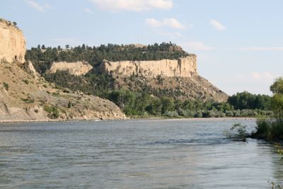
Rimrocks, Sandstone cliffs in Billings, United States.

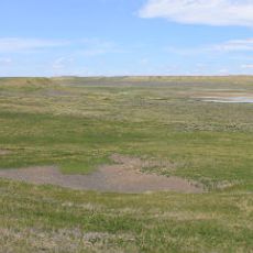
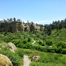
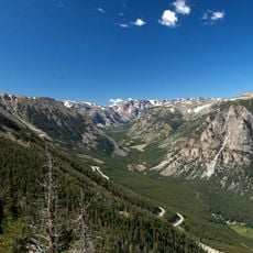
The Rimrocks are towering sandstone cliffs that run for miles along Billings, rising sharply above the Yellowstone River and overlooking the city below. These massive formations create a dramatic natural boundary between the river valley and the surrounding landscape.

These cliffs formed roughly 80 million years ago when the area was the shoreline of an ancient inland sea. Over millions of years, the Yellowstone River carved and shaped the rock layers into the steep walls visible today.

Local Native American nations viewed these cliffs as sacred locations for rituals and watching over the land. The sites remain deeply meaningful in the spiritual life of these communities.

Several parks and trails along the formation provide different access points for visitors of varying fitness levels. Wear sturdy footwear and plan your visit during spring or fall when temperatures are more comfortable for walking.

Early European traders used natural crevices within the sandstone for shelter during harsh winters in the 1800s. Researchers later discovered remnants of these temporary dwellings hidden within the rock formations.

The community of curious travelers

AroundUs brings together thousands of curated places, local tips, and hidden gems, enriched daily by 60,000 contributors worldwide.

Start exploring
GPS coordinates
45.80222,-108.57944
Latest update
December 9, 2025 18:40
Around this place
Lewis and Clark National Historic Trail
United States of America

Lewis and Clark National Historic Trail

49.6 km
Pictograph Cave
United States of America

Pictograph Cave

13.3 km
First Interstate Center
United States of America

First Interstate Center

5.6 km
Moss Mansion
United States of America

Moss Mansion

5.5 km
ZooMontana
United States of America

ZooMontana

8.5 km
Chief Plenty Coups State Park and Home
United States of America

Chief Plenty Coups State Park and Home

41.9 km
Rimrock Auto Arena at MetraPark
United States of America

Rimrock Auto Arena at MetraPark

7.9 km
Lake Elmo State Park
United States of America

Lake Elmo State Park

8.9 km
Dude Rancher Lodge
United States of America

Dude Rancher Lodge

3.7 km
Northern Hotel
United States of America

Northern Hotel

6.2 km
Western Heritage Center
United States of America

Western Heritage Center

6.2 km
St. Patrick's Co-Cathedral
United States of America

St. Patrick's Co-Cathedral

5.8 km
Alberta Bair Theater
United States of America

Alberta Bair Theater

6 km
Hailstone National Wildlife Refuge
United States of America

Hailstone National Wildlife Refuge

51.7 km
Pictograph Cave State Park
United States of America

Pictograph Cave State Park

13.5 km
The Reef
United States of America

The Reef

7.7 km
Prescott Commons
United States of America

Prescott Commons

2.2 km
Masonic Temple
United States of America

Masonic Temple

6 km
Austin North House
United States of America

Austin North House

5.6 km
Stoltz House
United States of America

Stoltz House

32.3 km
Joliet Bridge
United States of America

Joliet Bridge

46.8 km
Fromberg Opera House
United States of America

Fromberg Opera House

52.2 km
Billings Chamber of Commerce Building
United States of America

Billings Chamber of Commerce Building

6.1 km
Moss Mansion Museum
United States of America

Moss Mansion Museum

5.5 km
Fromberg Concrete Arch Bridge
United States of America

Fromberg Concrete Arch Bridge

51.8 km
Rock Creek
United States of America

Rock Creek

36 km
Babcock Theatre
United States of America

Babcock Theatre

6 km
Yellowstone Kelly Interpretive Site
United States of America

Yellowstone Kelly Interpretive Site

7.1 km
Show the full map
« Rimrocks - Sandstone cliffs in Billings, United States » is provided by Around Us (aroundus.com). Images and texts are derived from Wikimedia project under a Creative Commons license. You are allowed to copy, distribute, and modify copies of this page, under the conditions set by the license, as long as this note is clearly visible.

Discover hidden gems everywhere you go!

From secret cafés to breathtaking viewpoints, skip the crowded tourist spots and find places that match your style. Our app makes it easy with voice search, smart filtering, route optimization, and insider tips from travelers worldwide. Download now for the complete mobile experience.

Around Us App Screenshot

A unique approach to discovering new places

Le Figaro

All the places worth exploring

France Info

A tailor-made excursion in just a few clicks

20 Minutes

Around Us
Travel Guide & Maps
Download

Send to your phone

QR Code
1

Open the camera app on your mobile.

2

Point at the QR code with your camera. A notification will appear.

3

Tap the notification to open the link.