Enable Location

We need your location to show you interesting places around you

Discover nearby places

Find interesting locations and hidden gems around you

Precise directions

Get accurate directions and distances to places

Your location is never shared with other users. It's only used when you tap the location button.

Log in to your account

Start exploring — it's free

Trusted by 62,830 travelers worldwide

Continue with Google
Continue with Apple
or

We will send you a code to connect

By continuing, you accept our Terms and Conditions and our Privacy Policy

Check your inbox

We've sent a pincode in your inbox. Please enter the code below.

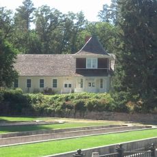
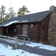
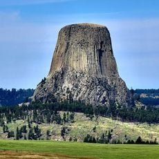
Devils Tower National Monument Visitor Center, National Park Service visitor center at Devils Tower National Monument, Wyoming

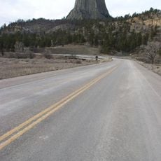
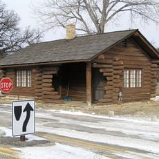
The Devils Tower National Monument Visitor Center sits at the base of the tower and houses exhibits about local geology, wildlife, and natural history within a wooden structure. The building serves as the main information hub and trailhead for exploring the surrounding landscape.

The center was built in 1935 with help from the Civilian Conservation Corps using ponderosa pine and local materials. The structure still carries its original 1930s design character.

The tower holds deep spiritual meaning for several Native American tribes, and the center shares their connection to the place through displays and talks. Visitors learn how these communities view and relate to the monument today.

The center has restrooms, a bookstore, and clear information to help you find your way on the trails ahead. Arriving early in the day helps you avoid crowds, especially during busy seasons.

The center welcomes over 400,000 visitors annually and offers National Parks Passport stamps for collectors. This makes it one of the busiest information hubs in the region.

The community of curious travelers

AroundUs brings together thousands of curated places, local tips, and hidden gems, enriched daily by 60,000 contributors worldwide.

Start exploring
Location
Inception
1935
GPS coordinates
44.59024,-104.72056
Latest update
December 15, 2025 13:25
Around this place
Spearfish Canyon
United States of America

Spearfish Canyon

70.2 km
Vore Buffalo Jump
United States of America

Vore Buffalo Jump

45.1 km
Keyhole State Park
United States of America

Keyhole State Park

29.9 km
Inyan Kara Mountain
United States of America

Inyan Kara Mountain

51.3 km
Ranch A
United States of America

Ranch A

49.3 km
Mount Theodore Roosevelt Monument
United States of America

Mount Theodore Roosevelt Monument

79.3 km
D.C. Booth Historic National Fish Hatchery
United States of America

D.C. Booth Historic National Fish Hatchery

69.4 km
Wyoming Highway 110
United States of America

Wyoming Highway 110

590 m
Old Headquarters Area Historic District
United States of America

Old Headquarters Area Historic District

42 m
Roughlock Falls Nature Area
United States of America

Roughlock Falls Nature Area

67.2 km
Sundance State Bank Building
United States of America

Sundance State Bank Building

33.9 km
Episcopal Church of All Angels
United States of America

Episcopal Church of All Angels

69.1 km
Entrance Station
United States of America

Entrance Station

1.6 km
DXN Bridge
United States of America

DXN Bridge

47.2 km
Sundance School
United States of America

Sundance School

34.1 km
Gillette City Hall
United States of America

Gillette City Hall

63.9 km
First Congregational United Church of Christ
United States of America

First Congregational United Church of Christ

69.5 km
James A. Corbin House
United States of America

James A. Corbin House

69.4 km
Devils Tower Information Marker
United States of America

Devils Tower Information Marker

4.3 km
Spearfish Filling Station
United States of America

Spearfish Filling Station

69.3 km
Webb S. Knight House
United States of America

Webb S. Knight House

69.5 km
Thomas Haskins Gay House
United States of America

Thomas Haskins Gay House

69.5 km
Belle Fourche Commercial Historic District
United States of America

Belle Fourche Commercial Historic District

69.3 km
Belle Fourche Band Shell
United States of America

Belle Fourche Band Shell

69.6 km
Arthur Hewes House
United States of America

Arthur Hewes House

68.5 km
Termesphere Gallery
United States of America

Termesphere Gallery

72.6 km
Gillette Fishing Lake
United States of America

Gillette Fishing Lake

70.9 km
Gillette College Pedestrian Bridge
United States of America

Gillette College Pedestrian Bridge

72.4 km
Show the full map
« Devils Tower National Monument Visitor Center - National Park Service visitor center at Devils Tower National Monument, Wyoming » is provided by Around Us (aroundus.com). Images and texts are derived from Wikimedia project under a Creative Commons license. You are allowed to copy, distribute, and modify copies of this page, under the conditions set by the license, as long as this note is clearly visible.

Discover hidden gems everywhere you go!

From secret cafés to breathtaking viewpoints, skip the crowded tourist spots and find places that match your style. Our app makes it easy with voice search, smart filtering, route optimization, and insider tips from travelers worldwide. Download now for the complete mobile experience.

Around Us App Screenshot

A unique approach to discovering new places

Le Figaro

All the places worth exploring

France Info

A tailor-made excursion in just a few clicks

20 Minutes

Around Us
Travel Guide & Maps
Download

Send to your phone

QR Code
1

Open the camera app on your mobile.

2

Point at the QR code with your camera. A notification will appear.

3

Tap the notification to open the link.