Chest opened
+${chestReward.xp} XP
Explorer
NOUVEAU ×${chestReward.collectible.quantity}
tapez pour fermer
Chest locked

Open chests in the app

Around Us is built for your phone — chests unlock when you walk, explore and capture nearby places.

Enable Location

We need your location to show you interesting places around you

Discover nearby places

Find interesting locations and hidden gems around you

Precise directions

Get accurate directions and distances to places

Your location is never shared with other users. It's only used when you tap the location button.

Tongue River

Log in to your account

Start exploring — it's free

Trusted by 72,885 travelers worldwide

Continue with Google
Continue with Apple
or

We will send you a code to connect

By continuing, you accept our Terms and Conditions and our Privacy Policy

Check your inbox

We've sent a pincode in your inbox. Please enter the code below.

Tongue River
Discussion Reviews 1 Photos
10.7k Popularity

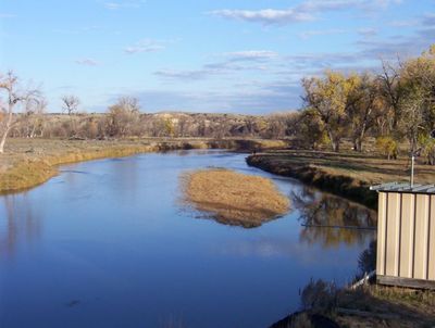
Tongue River, River in Custer County, United States

The Tongue River is a waterway that flows through southeastern Montana from the Bighorn Mountains toward the eastern plains. Starting at higher elevations in the mountains, it winds through several counties and agricultural areas before reaching its confluence with the Yellowstone River system.

The river was named during early American exploration of the region in the 1800s. The establishment of Fort Keogh near its mouth marked a turning point, as military presence reshaped the area following major conflicts between settlers and Native American groups.

The Tongue River runs past the Northern Cheyenne community lands, where generations of people have relied on its waters for sustenance and daily life. The river remains a focal point where local traditions and the land continue to shape each other.

Visitors can access the river for fishing, boating, and hiking through various public areas and access points along its length. The best time to visit is during warmer months when water conditions are more stable and pathways are easier to navigate.

The river passes through multiple ecological zones, each supporting different plant and animal communities as elevation drops from the mountains to the plains. This variety creates natural corridors that wildlife use when moving with seasonal changes.

The community of curious travelers

AroundUs brings together thousands of curated places, local tips, and hidden gems, enriched daily by 60,000 contributors worldwide.

Start exploring
Location
Location
Location
Location
Elevation above the sea
717 m
GPS coordinates
46.40917,-105.86667
Latest update
December 10, 2025 15:52
Around this place
Fort Keogh
United States of America

Fort Keogh

3.9 km
United States of America

Pirogue Island State Park

5 km
Main Street Historic District
United States of America

Main Street Historic District

1.5 km
Olive Hotel
United States of America

Olive Hotel

1.3 km
Holy Rosary Hospital
United States of America

Holy Rosary Hospital

2.4 km
United States of America

Carriage House Historic District

1.7 km
Miles City Waterworks Building and Pumping Plant Park
United States of America

Miles City Waterworks Building and Pumping Plant Park

357 m
United States of America

Locate Creek Bridge

43.7 km
Miles City Main Post Office
United States of America

Miles City Main Post Office

1.4 km
Ursuline Convent of the Sacred Heart
United States of America

Ursuline Convent of the Sacred Heart

1.9 km
Walrond and Elizabeth Snell House
United States of America

Walrond and Elizabeth Snell House

2.3 km
Mountain States Telephone and Telegraph Company Building
United States of America

Mountain States Telephone and Telegraph Company Building

1.6 km
George M. Miles House
United States of America

George M. Miles House

2.3 km
East Main Street Residential Historic District
United States of America

East Main Street Residential Historic District

2.4 km
William Harmon House
United States of America

William Harmon House

1.5 km
Thomas and Beulah Shore House
United States of America

Thomas and Beulah Shore House

2.7 km
United States of America

Pumping Plant Park

613 m
United States of America

Barley Reservoir

38.1 km
United States of America

Devils Backbone

39.8 km
United States of America

Baker Rapids

44.8 km
United States of America

Hamlick Reservoir

39.9 km
United States of America

Spotted Eagle Lake

2.3 km
United States of America

Buffalo Rapids

14.7 km
United States of America

Dixons Rapids

24.8 km
United States of America

Miles City Town and Country Club

2.4 km
United States of America

Eastern Montana Fairgrounds

1.2 km
United States of America

Statue, Work of art

3.7 km
United States of America

Horse on Carbon Hill

3.9 km
Show the full map
Reviews
Share your experience

No review yet

Discussions
Start a discussion...

No discussion yet

« Tongue River - River in Custer County, United States » is provided by Around Us (aroundus.com). Images and texts are derived from Wikimedia project under a Creative Commons license. You are allowed to copy, distribute, and modify copies of this page, under the conditions set by the license, as long as this note is clearly visible.

Discover hidden gems everywhere you go!

From secret cafés to breathtaking viewpoints, skip the crowded tourist spots and find places that match your style. Our app makes it easy with voice search, smart filtering, route optimization, and insider tips from travelers worldwide. Download now for the complete mobile experience.

Around Us App Screenshot

A unique approach to discovering new places

Le Figaro

All the places worth exploring

France Info

A tailor-made excursion in just a few clicks

20 Minutes

Around Us
Travel Guide & Maps
Download

Send to your phone

QR Code
1

Open the camera app on your mobile.

2

Point at the QR code with your camera. A notification will appear.

3

Tap the notification to open the link.