Enable Location

We need your location to show you interesting places around you

Discover nearby places

Find interesting locations and hidden gems around you

Precise directions

Get accurate directions and distances to places

Your location is never shared with other users. It's only used when you tap the location button.

Dawson Bridge

Log in to your account

Start exploring — it's free

Trusted by 62,324 travelers worldwide

Continue with Google
Continue with Apple
or

We will send you a code to connect

By continuing, you accept our Terms and Conditions and our Privacy Policy

Check your inbox

We've sent a pincode in your inbox. Please enter the code below.

Dawson Bridge

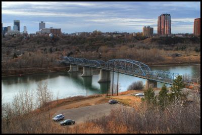
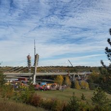
Dawson Bridge, Road bridge in Edmonton, Canada

Dawson Bridge is a road crossing that spans the North Saskatchewan River between Forest Heights and Riverdale. The structure carries two traffic lanes and includes dedicated pedestrian pathways for foot traffic and cyclists.

The structure opened in 1912 and was built as a critical transport link for the developing city of Edmonton. Before its reopening in 2010, the bridge underwent major repairs and upgrades to its infrastructure.

The bridge links two neighborhoods and serves as a daily crossing point for people moving between different parts of the city. It plays a practical role in how residents navigate and experience their communities across the river.

The bridge is open daily for standard traffic and is regularly maintained for safe crossing. Visitors should be aware of typical traffic times and watch for any ongoing maintenance work or weather conditions that might affect passage.

The bridge retains design elements from the early 20th century while being updated with modern safety technology. This blend of original engineering and contemporary standards shows how older structures can be adapted to meet current needs without losing their character.

The community of curious travelers

AroundUs brings together thousands of curated places, local tips, and hidden gems, enriched daily by 60,000 contributors worldwide.

Start exploring
Location
Official opening
1912
Length
236.5 m
GPS coordinates
53.54900,-113.46700
Latest update
December 13, 2025 17:00
« Dawson Bridge - Road bridge in Edmonton, Canada » is provided by Around Us (aroundus.com). Images and texts are derived from Wikimedia project under a Creative Commons license. You are allowed to copy, distribute, and modify copies of this page, under the conditions set by the license, as long as this note is clearly visible.

Discover hidden gems everywhere you go!

From secret cafés to breathtaking viewpoints, skip the crowded tourist spots and find places that match your style. Our app makes it easy with voice search, smart filtering, route optimization, and insider tips from travelers worldwide. Download now for the complete mobile experience.

Around Us App Screenshot

A unique approach to discovering new places

Le Figaro

All the places worth exploring

France Info

A tailor-made excursion in just a few clicks

20 Minutes

Around Us
Travel Guide & Maps
Download

Send to your phone

QR Code
1

Open the camera app on your mobile.

2

Point at the QR code with your camera. A notification will appear.

3

Tap the notification to open the link.