Chest opened
+${chestReward.xp} XP
Explorer
NOUVEAU ×${chestReward.collectible.quantity}
tapez pour fermer
Chest locked

Open chests in the app

Around Us is built for your phone — chests unlock when you walk, explore and capture nearby places.

Enable Location

We need your location to show you interesting places around you

Discover nearby places

Find interesting locations and hidden gems around you

Precise directions

Get accurate directions and distances to places

Your location is never shared with other users. It's only used when you tap the location button.

Woodward

Log in to your account

Start exploring — it's free

Trusted by 72,893 travelers worldwide

Continue with Google
Continue with Apple
or

We will send you a code to connect

By continuing, you accept our Terms and Conditions and our Privacy Policy

Check your inbox

We've sent a pincode in your inbox. Please enter the code below.

Discussion Reviews 3 Photos
27.8k Popularity

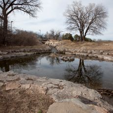
Woodward, County seat in northwestern Oklahoma, United States

Woodward is the county seat in northwestern Oklahoma and sits at an elevation of 582 meters. It serves as the main commercial center for a nine-county area in the region.

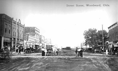
The Southern Kansas Railway established the town in 1887 as a cattle shipping point, spurring rapid settlement and economic growth. This railroad connection turned it into a major trading hub for the surrounding area.

The Plains Indians and Pioneers Museum displays exhibits about Native American tribes, early settlers, and ranching practices that shaped the region. Walking through, you get a sense of how farming and livestock raising became central to local life.

Access to the area is provided by West Woodward Airport and the intersection of US Route 412 with State Highways 34 and 15. These transportation points make it easy to reach nearby towns and regions.

On April 9, 1947, the city was struck by Oklahoma's most severe tornado, which destroyed 100 city blocks and fundamentally changed local building codes. This disaster reshaped how structures were built in the region afterward.

The community of curious travelers

AroundUs brings together thousands of curated places, local tips, and hidden gems, enriched daily by 60,000 contributors worldwide.

Start exploring
Location
Elevation above the sea
582 m
Part of
Red Carpet Country
GPS coordinates
36.43306,-99.39778
Latest update
December 20, 2025 13:20
Around this place
Little Sahara State Park
United States of America

Little Sahara State Park

47.5 km
Alabaster Caverns State Park
United States of America

Alabaster Caverns State Park

37.1 km
Boiling Springs State Park
United States of America

Boiling Springs State Park

9.2 km
Fort Supply
United States of America

Fort Supply

21.6 km
United States of America

Fort Supply Lake

19 km
United States of America

Page Soddy

39.7 km
L. L. Stine House
United States of America

L. L. Stine House

583 m
United States of America

Hal and Fern Cooper Wildlife Management Area

15.9 km
United States of America

Dewey County Courthouse

58.7 km
United States of America

McAllister House

53.2 km
United States of America

Buffalo City Park Pavilion

48.8 km
Ellis County Courthouse
United States of America

Ellis County Courthouse

47.2 km
United States of America

I.O.O.F. Building of Buffalo

49.4 km
Harper County Courthouse
United States of America

Harper County Courthouse

49.1 km
United States of America

First Congregational Church

49.5 km
United States of America

Laverne's North Main Street District

54 km
The Artesian Beach
United States of America

The Artesian Beach

33.3 km
United States of America

Fort Supply Reservoir

19 km
United States of America

Barnitz Creek Site 3 Reservoir

65.5 km
Boiling Springs State Park Pool Bathhouse
United States of America

Boiling Springs State Park Pool Bathhouse

8.9 km
United States of America

Oknoname 093003 Reservoir

43.9 km
United States of America

Barnitz Creek Site 2 Reservoir

65.7 km
United States of America

McGill Number 13 Reservoir

55.9 km
Shattuck Windmill Museum
United States of America

Shattuck Windmill Museum

47.2 km
United States of America

Leedey Lake

65.9 km
United States of America

Oknoname 059053 Reservoir

43.9 km
United States of America

Oknoname 05905 Reservoir

60.8 km
United States of America

Oknoname 093011 Reservoir

61.7 km
Show the full map
Reviews
Share your experience

No review yet

Discussions
Start a discussion...

No discussion yet

« Woodward - County seat in northwestern Oklahoma, United States » is provided by Around Us (aroundus.com). Images and texts are derived from Wikimedia project under a Creative Commons license. You are allowed to copy, distribute, and modify copies of this page, under the conditions set by the license, as long as this note is clearly visible.

Discover hidden gems everywhere you go!

From secret cafés to breathtaking viewpoints, skip the crowded tourist spots and find places that match your style. Our app makes it easy with voice search, smart filtering, route optimization, and insider tips from travelers worldwide. Download now for the complete mobile experience.

Around Us App Screenshot

A unique approach to discovering new places

Le Figaro

All the places worth exploring

France Info

A tailor-made excursion in just a few clicks

20 Minutes

Around Us
Travel Guide & Maps
Download

Send to your phone

QR Code
1

Open the camera app on your mobile.

2

Point at the QR code with your camera. A notification will appear.

3

Tap the notification to open the link.