Ochiltree County

Log in to your account

AroundUs is a community-driven map of interesting places, built by curious explorers like you. It grows with every review, story, and photo you share.
Connect to save your favorite spots, contribute locations, and create personalized routes.
Continue with Google
Continue with Apple
Continue with X
Continue with Facebook
Continue with email
By continuing, you accept our Terms and Conditions and our Privacy Policy
Create an account
Add to collection
Map
Suggest a change
Share

Ochiltree County, County administrative division in Texas Panhandle, United States

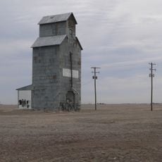
Ochiltree County sits in the northern Texas Panhandle with Perryton serving as its administrative and commercial center. The landscape is dominated by ranchland and agricultural areas, with Perryton providing the main services and facilities for the region.

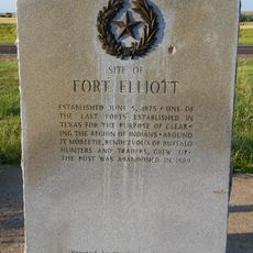
The county was established in 1889 during Texas territorial organization efforts, with Perryton becoming its administrative seat in 1919. This founding coincided with railroad expansion into the region, which opened economic opportunities.

The name Perryton honors an early settler and the area continues to reflect its agricultural roots through local events and community gatherings. People here maintain strong ties to ranching and farming traditions that shape how they spend their time together.

Government services and facilities are concentrated in Perryton and easily accessible for visitors needing local information or administrative help. The area has limited public transportation, so having your own vehicle makes getting around much more practical.

A powerful tornado struck Perryton in June 2023, causing significant damage that dramatically altered the downtown area. This natural disaster became a defining moment for the community and remains fresh in people's memories.

Location: Texas

Inception: 1889

Capital city: Perryton

Shares border with: Hansford County, Texas County, Beaver County, Lipscomb County, Roberts County

Website: https://co.ochiltree.tx.us

GPS coordinates: 36.28000,-100.81000

Latest update: December 7, 2025 20:44

Photos
Around this place
Lake Meredith
United States of America

Lake Meredith

91.9 km
Woo Cheong Pawn Shop
China

Woo Cheong Pawn Shop

69.7 km
Fort Supply
United States of America

Fort Supply

116.7 km
McClellan Creek National Grassland
United States of America

McClellan Creek National Grassland

119.2 km
Fort Elliott
United States of America

Fort Elliott

90.6 km
Devils Rope Barbed Wire Museum
United States of America

Devils Rope Barbed Wire Museum

118.3 km
Carson County Square House Museum
United States of America

Carson County Square House Museum

116.1 km
Franklin Hall
United States of America

Franklin Hall

81.8 km
Texas County Courthouse
United States of America

Texas County Courthouse

74.9 km
Dorothy's House and Land of Oz
United States of America

Dorothy's House and Land of Oz

84.5 km
Roberts County Courthouse
United States of America

Roberts County Courthouse

67.2 km
Hooker Woodframe Grain Elevator
United States of America

Hooker Woodframe Grain Elevator

74.6 km
Lipscomb County Courthouse
United States of America

Lipscomb County Courthouse

48.7 km
Ellis County Courthouse
United States of America

Ellis County Courthouse

94.8 km
Gray County Courthouse
United States of America

Gray County Courthouse

83.9 km
Devil's Rope Museum
United States of America

Devil's Rope Museum

118.3 km
Pampa City Hall
United States of America

Pampa City Hall

84 km
Freedom Museum USA
United States of America

Freedom Museum USA

83.9 km
Ellis Theatre
United States of America

Ellis Theatre

13.1 km
Palace Theatre
United States of America

Palace Theatre

55.8 km
Morley Theatre
United States of America

Morley Theatre

85.4 km
Lyric Cinema
United States of America

Lyric Cinema

35.7 km
White Deer Land Company Building
United States of America

White Deer Land Company Building

84.1 km
McLean Commercial Historic District
United States of America

McLean Commercial Historic District

118.1 km
Shattuck Windmill Museum
United States of America

Shattuck Windmill Museum

83.4 km
Phillips 66 Station (McLean, Texas)
United States of America

Phillips 66 Station (McLean, Texas)

118.1 km
Roberts County Museum
United States of America

Roberts County Museum

67.3 km
Canadian River Wagon Bridge
United States of America

Canadian River Wagon Bridge

55.1 km
Show the full map
Reviews

Visited this place? Tap the stars to rate it and share your experience / photos with the community! Try now! You can cancel it anytime.

Administrative divisions
« Ochiltree County - County administrative division in Texas Panhandle, United States » is provided by Around Us (aroundus.com). Images and texts are derived from Wikimedia project under a Creative Commons license. You are allowed to copy, distribute, and modify copies of this page, under the conditions set by the license, as long as this note is clearly visible.

Discover hidden gems everywhere you go!

From secret cafés to breathtaking viewpoints, skip the crowded tourist spots and find places that match your style. Our app makes it easy with voice search, smart filtering, route optimization, and insider tips from travelers worldwide. Download now for the complete mobile experience.

Around Us App Screenshot

A unique approach to discovering new places

Le Figaro

All the places worth exploring

France Info

A tailor-made excursion in just a few clicks

20 Minutes