Enable Location

We need your location to show you interesting places around you

Discover nearby places

Find interesting locations and hidden gems around you

Precise directions

Get accurate directions and distances to places

Your location is never shared with other users. It's only used when you tap the location button.

Threatt Filling Station

Log in to your account

Start exploring — it's free

Trusted by 62,574 travelers worldwide

Continue with Google
Continue with Apple
or

We will send you a code to connect

By continuing, you accept our Terms and Conditions and our Privacy Policy

Check your inbox

We've sent a pincode in your inbox. Please enter the code below.

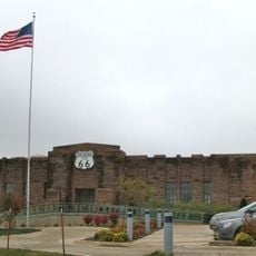
Threatt Filling Station, Historic filling station on Route 66, Oklahoma, US

Threatt Filling Station is a roadside gas station along Historic Route 66 near Luther, Oklahoma, built from sandstone in the early 1900s. The structure displays wide eaves and triangular braces at each gable end, keeping its original architectural character intact.

Allen Threatt established this filling station in 1915 as a stopping point for African American travelers on Route 66 during the era of segregation. The building was later listed on the National Register of Historic Places and received preservation grants.

The station represents the evolution of transportation in Oklahoma, marking the transition from horse-drawn carriages to motor vehicles in rural America.

The station sits at the intersection of Historic Route 66 and North Pottawatomi Road in Luther and can be viewed from the roadside. Visitors can easily observe and photograph the exterior from the street without entering private property.

The station was specifically designed to serve African American travelers and played an important role in travel history during segregation. The site is now recognized as a symbol of resilience and the stories of those who faced inequality on the road.

The community of curious travelers

AroundUs brings together thousands of curated places, local tips, and hidden gems, enriched daily by 60,000 contributors worldwide.

Start exploring
Location
Inception
1915
GPS coordinates
35.66637,-97.14151
Latest update
December 18, 2025 11:40
Around this place
National Cowboy & Western Heritage Museum
United States of America

National Cowboy & Western Heritage Museum

34.2 km
Frontier City
United States of America

Frontier City

28.6 km
Oklahoma City Zoo and Botanical Garden
United States of America

Oklahoma City Zoo and Botanical Garden

34 km
Hall of Great Western Performers
United States of America

Hall of Great Western Performers

34.2 km
Hall of Great Westerners
United States of America

Hall of Great Westerners

34.2 km
Oak Tree National
United States of America

Oak Tree National

33.4 km
Arcadia Round Barn
United States of America

Arcadia Round Barn

16.7 km
Arcadia Lake
United States of America

Arcadia Lake

20.1 km
Scottish Rite Temple
United States of America

Scottish Rite Temple

34 km
Steel Lasso
United States of America

Steel Lasso

28.6 km
Oklahoma City Hindu Temple
United States of America

Oklahoma City Hindu Temple

30.3 km
Carnegie Library
United States of America

Carnegie Library

34.5 km
Chandler Armory
United States of America

Chandler Armory

24.3 km
Old North Tower, University of Central Oklahoma
United States of America

Old North Tower, University of Central Oklahoma

30.1 km
USA Softball Hall of Fame Complex
United States of America

USA Softball Hall of Fame Complex

33.2 km
Logan County Courthouse
United States of America

Logan County Courthouse

34.5 km
American Legion Hut
United States of America

American Legion Hut

30.6 km
First Presbyterian Church of Chandler
United States of America

First Presbyterian Church of Chandler

23.7 km
St. Stephen's Episcopal Church
United States of America

St. Stephen's Episcopal Church

23.8 km
St. Paul Baptist Church and Cemetery
United States of America

St. Paul Baptist Church and Cemetery

22.9 km
St. Cloud Hotel
United States of America

St. Cloud Hotel

24.3 km
Conklin House
United States of America

Conklin House

23.8 km
Choctaw Creek
United States of America

Choctaw Creek

24.1 km
Route 66 Interpretive Center
United States of America

Route 66 Interpretive Center

24.4 km
Oklahoma Territorial Museum
United States of America

Oklahoma Territorial Museum

34.6 km
45th Infantry Division Museum
United States of America

45th Infantry Division Museum

34.9 km
The American Pigeon Museum & Library
United States of America

The American Pigeon Museum & Library

33.2 km
Midway Club
United States of America

Midway Club

28.3 km
Show the full map
« Threatt Filling Station - Historic filling station on Route 66, Oklahoma, US » is provided by Around Us (aroundus.com). Images and texts are derived from Wikimedia project under a Creative Commons license. You are allowed to copy, distribute, and modify copies of this page, under the conditions set by the license, as long as this note is clearly visible.

Discover hidden gems everywhere you go!

From secret cafés to breathtaking viewpoints, skip the crowded tourist spots and find places that match your style. Our app makes it easy with voice search, smart filtering, route optimization, and insider tips from travelers worldwide. Download now for the complete mobile experience.

Around Us App Screenshot

A unique approach to discovering new places

Le Figaro

All the places worth exploring

France Info

A tailor-made excursion in just a few clicks

20 Minutes

Around Us
Travel Guide & Maps
Download

Send to your phone

QR Code
1

Open the camera app on your mobile.

2

Point at the QR code with your camera. A notification will appear.

3

Tap the notification to open the link.