Chest opened
+${chestReward.xp} XP
Explorer
NOUVEAU ×${chestReward.collectible.quantity}
tapez pour fermer
Chest locked

Open chests in the app

Around Us is built for your phone — chests unlock when you walk, explore and capture nearby places.

Enable Location

We need your location to show you interesting places around you

Discover nearby places

Find interesting locations and hidden gems around you

Precise directions

Get accurate directions and distances to places

Your location is never shared with other users. It's only used when you tap the location button.

Log in to your account

Start exploring — it's free

Trusted by 72,889 travelers worldwide

Continue with Google
Continue with Apple
or

We will send you a code to connect

By continuing, you accept our Terms and Conditions and our Privacy Policy

Check your inbox

We've sent a pincode in your inbox. Please enter the code below.

Kanopolis Lake
Discussion Reviews Photo
5.5k Popularity

Kanopolis Lake, body of water

Kanopolis Lake is a large reservoir in central Kansas formed in 1948 by the Kanopolis Dam. Water is fed by the Smoky Hill River and covers approximately 3,400 acres with an average depth of 15 feet (4.6 meters), reaching as deep as 40 feet (12 meters) near the dam structure.

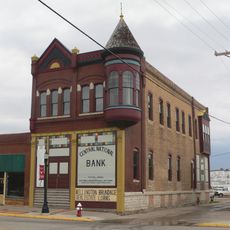
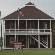
The region was inhabited by Native Americans such as the Pawnee, Cheyenne, and Sioux who carved petroglyphs into rocks. In the 1800s, Spanish explorers and French fur traders moved through, while soldiers later established Fort Harker and ranchers shaped the landscape with cattle operations and farming.

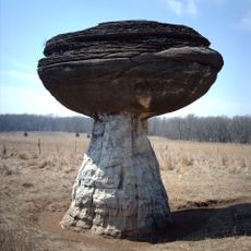
The name Kanopolis comes from a town founded in 1886 that was intended to become Kansas's capital. Rock formations display petroglyphs carved by Native Americans that tell stories of their lives and remain visible today as they walk through the area.

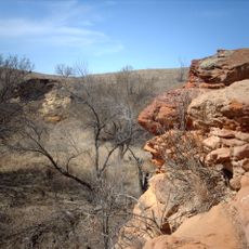
The area is about 33 miles (53 kilometers) southwest of Salina, Kansas and accessible via Kansas Route 141. Visitors will find campgrounds with primitive and full-service facilities, boat ramps, beaches, and more than 30 miles (48 kilometers) of trails for hiking and biking.

The area was once home to mammoths and dinosaurs and contains fossils of sea creatures from when Kansas lay beneath a shallow sea. The region is also known as a location where famous frontier figures like Buffalo Bill and Wild Bill Hickok were active during their frontier adventures.

The community of curious travelers

AroundUs brings together thousands of curated places, local tips, and hidden gems, enriched daily by 60,000 contributors worldwide.

Start exploring
Location
GPS coordinates
38.61890,-97.96790
Latest update
February 7, 2026 11:00
Around this place
Mushroom Rock State Park
United States of America

Mushroom Rock State Park

13.1 km
Kanopolis State Park
United States of America

Kanopolis State Park

5.1 km
United States of America

Faris Caves

14.5 km
Fort Harker
United States of America

Fort Harker

19.3 km
Kansas Motorcycle Museum
United States of America

Kansas Motorcycle Museum

13.7 km
Swedish Pavilion
United States of America

Swedish Pavilion

26.2 km
Hans Hanson House
United States of America

Hans Hanson House

13.7 km
Farmers State Bank
United States of America

Farmers State Bank

25.9 km
Johnson House
United States of America

Johnson House

25.5 km
United States of America

United States Post Office–Lindsborg

26 km
Smoky Valley Roller Mill
United States of America

Smoky Valley Roller Mill

26.2 km
United States of America

Rosberg-Holmgren-Clareen Block

25.9 km
United States of America

Berquist & Nelson Drugstore Building

25.9 km
United States of America

Paint Creek site

25.6 km
United States of America

Holmberg and Johnson Blacksmith Shop

25.9 km
United States of America

Soldier Cap Mound

18.3 km
Arthur Larkin House
United States of America

Arthur Larkin House

26.1 km
Teichgraeber–Runbeck House
United States of America

Teichgraeber–Runbeck House

26.2 km
Ellsworth Downtown Historic District
United States of America

Ellsworth Downtown Historic District

26 km
Perry Hodgden House
United States of America

Perry Hodgden House

26 km
Insurance Building
United States of America

Insurance Building

26 km
The Museum at Rolling Hills Zoo
United States of America

The Museum at Rolling Hills Zoo

31.3 km
Ft Harker Museum
United States of America

Ft Harker Museum

19.7 km
United States of America

Clear Pond

30.6 km
Fort Harker Officers' Quarters
United States of America

Fort Harker Officers' Quarters

19.5 km
Fort Harker Guardhouse
United States of America

Fort Harker Guardhouse

19.7 km
United States of America

Lindsborg Golf Course

29.1 km

Presser Hall

26 km
Show the full map
Reviews
Share your experience

No review yet

Discussions
Start a discussion...

No discussion yet

« Kanopolis Lake - body of water » is provided by Around Us (aroundus.com). Images and texts are derived from Wikimedia project under a Creative Commons license. You are allowed to copy, distribute, and modify copies of this page, under the conditions set by the license, as long as this note is clearly visible.

Discover hidden gems everywhere you go!

From secret cafés to breathtaking viewpoints, skip the crowded tourist spots and find places that match your style. Our app makes it easy with voice search, smart filtering, route optimization, and insider tips from travelers worldwide. Download now for the complete mobile experience.

Around Us App Screenshot

A unique approach to discovering new places

Le Figaro

All the places worth exploring

France Info

A tailor-made excursion in just a few clicks

20 Minutes

Around Us
Travel Guide & Maps
Download

Send to your phone

QR Code
1

Open the camera app on your mobile.

2

Point at the QR code with your camera. A notification will appear.

3

Tap the notification to open the link.