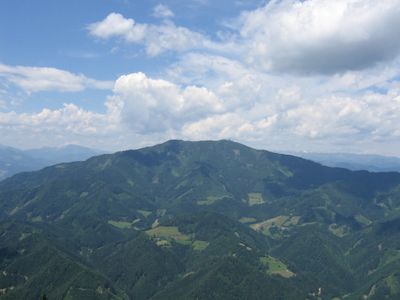
Rennfeld, Mountain summit in Styria, Austria.
Rennfeld is a summit in the Fischbach Alps standing at 1629 meters in Styria. The peak opens into a grassy zone that contrasts with the forested slopes leading up from the valley below.
The mountain has served as the westernmost peak of the Fischbach Alps range for centuries, marking a natural geographical boundary in the region. This location gave it significance in how people understood the boundaries of their landscape.
The summit holds meaning for people living in Bruck an der Mur, who regularly visit it as part of their outdoor activities throughout the year. It shapes how locals experience their landscape and serves as a backdrop to family outings and weekend hikes.
Several marked trails start from Frauenberg and lead to the summit with options for different experience levels. The Ottokar-Kernstock-Haus sits lower on the mountain and provides a place to rest during your hike.
Natural blueberry plants grow across the open summit area where hikers can pick berries during their rest. An orientation table at the peak helps identify the surrounding mountains and valleys when you stand at the top.
Location: Styria
Elevation above the sea: 1,629 m
Accessibility: Wheelchair inaccessible
Website: https://de.wikipedia.org/wiki/Datei:Rennfeld_Gipfel_Panorama.png
GPS coordinates: 47.40432,15.35927
Latest update: December 14, 2025 11:03
Heilig-Geist-Kirche
5.7 km
Schüsserlbrunn Pilgrimage Church
6.3 km
Lokalbahn Mixnitz–Sankt Erhard
4.3 km
Schloss Pernegg
4.9 km
Maria Rehkogel, Frauenberg
2.8 km
Kalvarienbergkirche zum blutschwitzenden Heiland, Bruck
5.8 km
Burg Pernegg
4.7 km
Pfarrkirche hl. Familie und Pfarrzentrum, Kapfenberg
6.2 km
Pfarrkirche hl. Maximilian, Pernegg
5.2 km
Frauenkirche Pernegg
5.1 km
Wegkapellen Pernegg
5.2 km
Kirchhof, ehem. Friedhof
5.2 km
Kath. Filialkirche hl. Nikolaus in Pischk und ehem. Friedhof
5.6 km
Kapelle beim Berglhof
5.5 km
Loretokapelle, Kapfenberg
6.1 km
Karl Morré monument, Bruck an der Mur
6.3 km
Wehranlage Zlatten
5.1 km
Schloss Graschnitz
6.3 km
Pfarrhof Frauenberg Maria – Rehkogel
2.9 km
Ehem. Mesnerhaus, Haus St. Josef
2.8 km
Wehranlage Zlatten (in Zlatten)
5.2 km
Power house of the Pernegg power plant
4.8 km
Kalvarienberg
5.7 km
Pavillon des Bezirksaltenheims
6 km
Pfarrzentrum mit Nebengebäuden
6.2 km
Pfarrhof
5.2 km
Volksschule, Haus der Begegnung, Sporthalle
6.1 km
Zwei Postmeilensteine und zwei Prellsteine
5.6 kmVisited this place? Tap the stars to rate it and share your experience / photos with the community! Try now! You can cancel it anytime.
Discover hidden gems everywhere you go!
From secret cafés to breathtaking viewpoints, skip the crowded tourist spots and find places that match your style. Our app makes it easy with voice search, smart filtering, route optimization, and insider tips from travelers worldwide. Download now for the complete mobile experience.
A unique approach to discovering new places❞
— Le Figaro
All the places worth exploring❞
— France Info
A tailor-made excursion in just a few clicks❞
— 20 Minutes