Chest opened
+${chestReward.xp} XP
Explorer
NOUVEAU ×${chestReward.collectible.quantity}
tapez pour fermer

See the monuments around you in AR Open chests in the app

Around Us is built for your phone — point your camera at the streets and discover the monuments and places around you in augmented reality. Around Us is built for your phone — chests unlock when you walk, explore and capture nearby places.

•

Enable Location

We need your location to show you interesting places around you

Discover nearby places

Find interesting locations and hidden gems around you

Precise directions

Get accurate directions and distances to places

Your location is never shared with other users. It's only used when you tap the location button.

Bilećko Lake

Log in to your account

Start exploring — it's free

Trusted by 93,364 travelers worldwide

Continue with Google
Continue with Apple
or

We will send you a code to connect

By continuing, you accept our Terms and Conditions and our Privacy Policy

Check your inbox

We've sent a pincode in your inbox. Please enter the code below.

Bilećko Lake, reservoir in Bosnia and Herzegovina

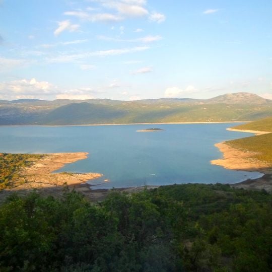
Bilećko Lake is a large artificial reservoir near the town of Bileća, created in 1968 when the Grančarevo Dam was constructed across the Trebišnjica River. The lake covers about 33 square kilometers, reaches depths exceeding 100 meters, sits at roughly 400 meters elevation, and is surrounded by white limestone mountains and rugged terrain.

The Grančarevo Dam on the Trebišnjica, 123 m high and 439 m wide at its crest, was completed in 1968 to feed the Trebinje I hydroelectric plant. Raising the water submerged the villages of Panik, Orah, Čepelica, Zadublje and Miruše, along with the Kosijerevo monastery, later moved to Petrovići in Banjani. The Perović bridge and a Roman settlement at Panik with baths and mosaics also went under. Sources differ on rank: Serbian lists call it among the largest Balkan reservoirs, Croatian calls it the second largest.

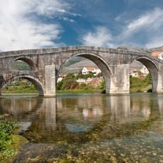
The reservoir submerged the village of Panik, where a Roman settlement with baths, thermal rooms and mosaics lay; the site is known as Leusinium. The Kosijerevo monastery was also flooded and later moved to Petrovići in Banjani. The Dobrićevo monastery and Perovića Bridge are the other monuments tied to the drowned valley.

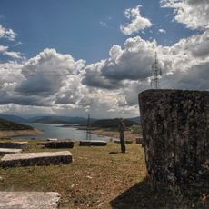
The southern end of the lake is narrower than the northern part and ends at the Grančarevo Dam, 123 m high and 439 m wide at the top, where the Trebinje I hydroelectric plant stands. The lake stretches 18 km in length and 3–4 km in width, with a maximum depth of 104 m at about 400 m above sea level. Water level varies, so the shoreline shifts; the exposed bank on the left of the view is mud and rock.

When the reservoir filled, the Trebišnjica drowned the village of Panik and its Roman settlement, Leusinium, whose villas, baths and mosaics lie under the water. The Kosijerevo monastery was moved to Petrovići in Banjani rather than lost. The Grančarevo dam that holds the lake is 123 m high and 439 m wide at its crest.

The community of curious travelers

AroundUs brings together thousands of curated places, local tips, and hidden gems, enriched daily by 93,364 contributors worldwide.
Start exploring
Elevation above the sea
383 m
GPS coordinates
42.82528,18.43806
Latest update
October 31, 2026 03:36
Around this place
Hercegovačka Gračanica
Bosnia and Herzegovina

Hercegovačka Gračanica

8.9 mi
Arslanagića Ćuprija
Bosnia and Herzegovina

Arslanagića Ćuprija

8.8 mi
Dobrićevo Monastery
Bosnia and Herzegovina

Dobrićevo Monastery

1.4 mi
Church of the transfiguration of Jesus Christ in Trebinje
Bosnia and Herzegovina

Church of the transfiguration of Jesus Christ in Trebinje

9.3 mi
Cathedral of the Birth of Mary
Bosnia and Herzegovina

Cathedral of the Birth of Mary

9.2 mi
Osman-paša Resulbegović mosque
Bosnia and Herzegovina

Osman-paša Resulbegović mosque

9.2 mi
Sultan Ahmed mosque
Bosnia and Herzegovina

Sultan Ahmed mosque

9.2 mi
Crkva Svetog Save
Bosnia and Herzegovina

Crkva Svetog Save

3.5 mi
Bileća necropolis
Bosnia and Herzegovina

Bileća necropolis

5.6 mi
Herzegovina Museum (Trebinje)
Bosnia and Herzegovina

Herzegovina Museum (Trebinje)

9.1 mi
Police City Stadium
Bosnia and Herzegovina

Police City Stadium

9.1 mi
Saint Lazarus church in Bileća
Bosnia and Herzegovina

Saint Lazarus church in Bileća

3.8 mi
Mičevac
Bosnia and Herzegovina

Mičevac

8.7 mi
Grebnice-Bunčići necropolis
Bosnia and Herzegovina

Grebnice-Bunčići necropolis

5 mi
Trebinje Transfiguration Cathedral
Bosnia and Herzegovina

Trebinje Transfiguration Cathedral

8.9 mi
Bosnia and Herzegovina

Биста Краља Петра I

9.2 mi
Bosnia and Herzegovina

Brankovića Kula

9.3 mi
Bosnia and Herzegovina

Stecci Necropolis Grebnice

5.6 mi
Bosnia and Herzegovina

Arslanagić Bridge

8.8 mi
Bosnia and Herzegovina

Uskotračna parna lokomotiva JŽ 83-056

9.3 mi
Bosnia and Herzegovina

Излетиште Студенац

8.6 mi
Bosnia and Herzegovina

Arslanagić Bridge

8.8 mi
Bosnia and Herzegovina

Memorial

9.1 mi
Bosnia and Herzegovina

Memorial

9.3 mi
Bosnia and Herzegovina

Spomenik "Herojima za slobodu"

9.2 mi
Bosnia and Herzegovina

Spomenik Jovanu Dučiću

9.2 mi
Bosnia and Herzegovina

Spomenik Petru II Petroviću Njegošu

9.2 mi
Bosnia and Herzegovina

Scenic viewpoint

8.8 mi
Show the full map
Reviews
Share your experience

No review yet

Discussions
Start a discussion...

No discussion yet

« Bilećko Lake - reservoir in Bosnia and Herzegovina » is provided by Around Us (aroundus.com). Images and texts are derived from Wikimedia project under a Creative Commons license. You are allowed to copy, distribute, and modify copies of this page, under the conditions set by the license, as long as this note is clearly visible.

Discover hidden gems everywhere you go!

From secret cafés to breathtaking viewpoints, skip the crowded tourist spots and find places that match your style. Our app makes it easy with voice search, smart filtering, route optimization, and insider tips from travelers worldwide. Download now for the complete mobile experience.

Around Us App Screenshot
❝

A unique approach to discovering new places❞

— Le Figaro

❝

All the places worth exploring❞

— France Info

❝

A tailor-made excursion in just a few clicks❞

— 20 Minutes

Around Us
Travel Guide & Maps
Download

Send to your phone

QR Code
1

Open the camera app on your mobile.

2

Point at the QR code with your camera. A notification will appear.

3

Tap the notification to open the link.