Enable Location

We need your location to show you interesting places around you

Discover nearby places

Find interesting locations and hidden gems around you

Precise directions

Get accurate directions and distances to places

Your location is never shared with other users. It's only used when you tap the location button.

Drežnica Valley

Log in to your account

Start exploring — it's free

Trusted by 63,029 travelers worldwide

Continue with Google
Continue with Apple
or

We will send you a code to connect

By continuing, you accept our Terms and Conditions and our Privacy Policy

Check your inbox

We've sent a pincode in your inbox. Please enter the code below.

Discussion Reviews 1 Photos
1.7k Popularity

Drežnica Valley, Protected valley in Herzegovina-Neretva Canton, Bosnia and Herzegovina

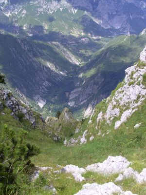
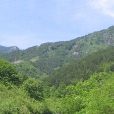
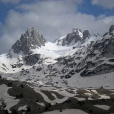
Drežnica Valley stretches between two mountains and forms an elongated valley with steep stone walls on either side. The Drežanka River flows through the bottom and creates several natural swimming spots at shallower sections.

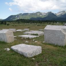
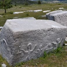
In the 14th century, noble families carved inscriptions into the rock walls to document their presence and influence in the region. These engravings show how important the valley was to local rulers of that time.

Fishing traditions shape the area, with local trout farms being part of everyday life here for generations. Visitors can see small breeding facilities along the river where fish are raised for regional restaurants.

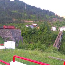
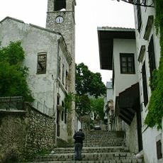
The valley has multiple access points, but the most popular starting spot is near the dam in Donje Selo, from where you can easily reach the river. The paths mostly follow the riverbank but are rocky in places and require sturdy footwear.

A waterfall cascades down the cliffs only a few times each year, after snow and heavy rain feed the mountains above. Spotting it requires visiting at exactly the right moment.

The community of curious travelers

AroundUs brings together thousands of curated places, local tips, and hidden gems, enriched daily by 60,000 contributors worldwide.

Start exploring
Location
Elevation above the sea
112 m
Address
Donja Drežnica bb, 88215 Mostar
GPS coordinates
43.52936,17.67948
Latest update
December 9, 2025 12:26
Around this place
Blidinje Nature Park
Bosnia and Herzegovina

Blidinje Nature Park

16.5 km
Die Brücke in Jablanica
Bosnia and Herzegovina

Die Brücke in Jablanica

15.4 km
Cathedral of the Holy Trinity, Mostar
Bosnia and Herzegovina

Cathedral of the Holy Trinity, Mostar

22.6 km
Stadion Pecara
Bosnia and Herzegovina

Stadion Pecara

18 km
Bijeli Brijeg Stadium
Bosnia and Herzegovina

Bijeli Brijeg Stadium

22.5 km
Bosnia and Herzegovina

Late antique basilica in Cim, the archaeological site

21 km
Mokri Dolac Stadium
Bosnia and Herzegovina

Mokri Dolac Stadium

29.2 km
Franciscan monastery of Široki Brijeg
Bosnia and Herzegovina

Franciscan monastery of Široki Brijeg

18.7 km
Franciscan monastery Humac
Bosnia and Herzegovina

Franciscan monastery Humac

18.7 km
Dugo polje
Bosnia and Herzegovina

Dugo polje

17 km
Pločno
Bosnia and Herzegovina

Pločno

12.7 km
Memorial Complex Neretva Battle
Bosnia and Herzegovina

Memorial Complex Neretva Battle

15.6 km
Clock Tower of Mostar
Bosnia and Herzegovina

Clock Tower of Mostar

22.6 km
Dugopolje necropolis
Bosnia and Herzegovina

Dugopolje necropolis

18.9 km
Zelena glava
Bosnia and Herzegovina

Zelena glava

18.2 km
Bishop’s Ordinariate
Bosnia and Herzegovina

Bishop’s Ordinariate

22.6 km
Bains municipaux de Mostar
Bosnia and Herzegovina

Bains municipaux de Mostar

22.6 km
Mosquée de Roznamedži Ibrahim-effendi
Bosnia and Herzegovina

Mosquée de Roznamedži Ibrahim-effendi

22.6 km
Plocno
Bosnia and Herzegovina

Plocno

12.7 km
Fontaine de la place Musalla
Bosnia and Herzegovina

Fontaine de la place Musalla

22.6 km
Church of St. Catherine
Bosnia and Herzegovina

Church of St. Catherine

27.8 km
Virgin Mary Church
Bosnia and Herzegovina

Virgin Mary Church

28.4 km
St. Anthony of Padua church in Cerov Dolac
Bosnia and Herzegovina

St. Anthony of Padua church in Cerov Dolac

25.8 km
Église du Sacré-Cœur-de-Jésus de Donji Crnač
Bosnia and Herzegovina

Église du Sacré-Cœur-de-Jésus de Donji Crnač

14.8 km
St. Elijah Church
Bosnia and Herzegovina

St. Elijah Church

15.9 km
Nécropole de Risovac
Bosnia and Herzegovina

Nécropole de Risovac

17.7 km
Église de la Nativité-de-la-Sainte-Vierge de Donja Britvica
Bosnia and Herzegovina

Église de la Nativité-de-la-Sainte-Vierge de Donja Britvica

16.8 km
Most Begića i Begovića
Bosnia and Herzegovina

Most Begića i Begovića

9.2 km
Show the full map
Reviews
Share your experience

No review yet

Discussions
Start a discussion...

No discussion yet

« Drežnica Valley - Protected valley in Herzegovina-Neretva Canton, Bosnia and Herzegovina » is provided by Around Us (aroundus.com). Images and texts are derived from Wikimedia project under a Creative Commons license. You are allowed to copy, distribute, and modify copies of this page, under the conditions set by the license, as long as this note is clearly visible.

Discover hidden gems everywhere you go!

From secret cafés to breathtaking viewpoints, skip the crowded tourist spots and find places that match your style. Our app makes it easy with voice search, smart filtering, route optimization, and insider tips from travelers worldwide. Download now for the complete mobile experience.

Around Us App Screenshot

A unique approach to discovering new places

Le Figaro

All the places worth exploring

France Info

A tailor-made excursion in just a few clicks

20 Minutes

Around Us
Travel Guide & Maps
Download

Send to your phone

QR Code
1

Open the camera app on your mobile.

2

Point at the QR code with your camera. A notification will appear.

3

Tap the notification to open the link.