Enable Location

We need your location to show you interesting places around you

Discover nearby places

Find interesting locations and hidden gems around you

Precise directions

Get accurate directions and distances to places

Your location is never shared with other users. It's only used when you tap the location button.

Fort Schlosser

Log in to your account

Start exploring — it's free

Trusted by 63,003 travelers worldwide

Continue with Google
Continue with Apple
or

We will send you a code to connect

By continuing, you accept our Terms and Conditions and our Privacy Policy

Check your inbox

We've sent a pincode in your inbox. Please enter the code below.

Fort Schlosser
Discussion Reviews 1 Photos
3.9k Popularity

Fort Schlosser, Military fortification in Chippawa Region, Niagara Falls, Canada

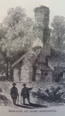
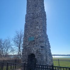
Fort Schlosser was a British military fortification in the Chippawa region near Niagara Falls, located directly along the Niagara River shoreline. The structure featured a stone chimney, was enclosed by a wooden stockade, and contained storehouses as well as separate quarters for officers and soldiers.

British forces built the fort in 1760 to control and defend the upper entrance to the portage route around Niagara Falls, equipped with four cannons. It became important during colonial conflicts and was seized during subsequent military operations.

The name comes from Captain Joseph Schlosser of the Royal American Regiment of Foot, following British military naming traditions. The site today marks where different colonial powers and indigenous peoples encountered one another at this key location along the river.

The site is located along the Niagara River shoreline near the Porter-Barton Dock landing area and is visible from outside viewpoints. Visitors should understand that what remains today are primarily archaeological foundations and the distinctive stone chimney structure.

In 1813, a surprise attack by British and Canadian forces overwhelmed the garrison and captured the entire American garrison. The raiding forces secured a brass cannon and many muskets in this significant military action.

The community of curious travelers

AroundUs brings together thousands of curated places, local tips, and hidden gems, enriched daily by 60,000 contributors worldwide.

Start exploring
Inception
1760
GPS coordinates
43.07754,-79.01556
Latest update
December 11, 2025 18:05
Around this place
Canada

Republic of Canada

2.5 km
Adams Power Plant Transformer House
United States of America

Adams Power Plant Transformer House

2.3 km
Aquarium of Niagara
United States of America

Aquarium of Niagara

4.1 km
Three Sisters Islands
United States of America

Three Sisters Islands

4.1 km
North Grand Island Bridge
United States of America

North Grand Island Bridge

2.2 km
Old Stone Chimney
United States of America

Old Stone Chimney

2.4 km
Niagara Falls Convention and Civic Center
United States of America

Niagara Falls Convention and Civic Center

3.5 km
United Office Building
United States of America

United Office Building

4 km
Buckhorn Island State Park
United States of America

Buckhorn Island State Park

3 km
Niagara Falls Public Library
United States of America

Niagara Falls Public Library

4 km
Hyde Park
United States of America

Hyde Park

2.9 km
Holy Trinity Roman Catholic Church Complex
United States of America

Holy Trinity Roman Catholic Church Complex

2.5 km
Whitney Mansion
United States of America

Whitney Mansion

3.5 km
Niagara Falls City Hall
United States of America

Niagara Falls City Hall

3.8 km
First Unitarian Universalist Church of Niagara
United States of America

First Unitarian Universalist Church of Niagara

3.9 km
Park Place Historic District
United States of America

Park Place Historic District

3.9 km
Mount St. Mary's Hospital
United States of America

Mount St. Mary's Hospital

3.6 km
Jefferson Apartment Building
United States of America

Jefferson Apartment Building

3.7 km
Holley-Rankine House
United States of America

Holley-Rankine House

3.3 km
First Presbyterian Manse
United States of America

First Presbyterian Manse

3.7 km
Niagara Falls School District Administration Building
United States of America

Niagara Falls School District Administration Building

3.6 km
St. Mary's Nurses' Residence
United States of America

St. Mary's Nurses' Residence

3.7 km
Hazard H. Sheldon House
United States of America

Hazard H. Sheldon House

3.8 km
Chilton Avenue-Orchard Parkway Historic District
United States of America

Chilton Avenue-Orchard Parkway Historic District

4.1 km
Cummington Square
Canada

Cummington Square

3.5 km
Holy Trinity Church
Canada

Holy Trinity Church

3.8 km
Chippawa Town Hall
Canada

Chippawa Town Hall

3.6 km
Laura Secord House
Canada

Laura Secord House

3.6 km
Show the full map
Reviews
Share your experience

No review yet

Discussions
Start a discussion...

No discussion yet

« Fort Schlosser - Military fortification in Chippawa Region, Niagara Falls, Canada » is provided by Around Us (aroundus.com). Images and texts are derived from Wikimedia project under a Creative Commons license. You are allowed to copy, distribute, and modify copies of this page, under the conditions set by the license, as long as this note is clearly visible.

Discover hidden gems everywhere you go!

From secret cafés to breathtaking viewpoints, skip the crowded tourist spots and find places that match your style. Our app makes it easy with voice search, smart filtering, route optimization, and insider tips from travelers worldwide. Download now for the complete mobile experience.

Around Us App Screenshot

A unique approach to discovering new places

Le Figaro

All the places worth exploring

France Info

A tailor-made excursion in just a few clicks

20 Minutes

Around Us
Travel Guide & Maps
Download

Send to your phone

QR Code
1

Open the camera app on your mobile.

2

Point at the QR code with your camera. A notification will appear.

3

Tap the notification to open the link.