Enable Location

We need your location to show you interesting places around you

Discover nearby places

Find interesting locations and hidden gems around you

Precise directions

Get accurate directions and distances to places

Your location is never shared with other users. It's only used when you tap the location button.

Saint Leonard – Van Buren Bridge

Log in to your account

Start exploring — it's free

Trusted by 63,884 travelers worldwide

Continue with Google
Continue with Apple
or

We will send you a code to connect

By continuing, you accept our Terms and Conditions and our Privacy Policy

Check your inbox

We've sent a pincode in your inbox. Please enter the code below.

Saint Leonard – Van Buren Bridge
Discussion Reviews 1 Photos
1.6k Popularity

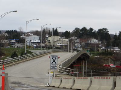
Saint Leonard – Van Buren Bridge, International road bridge between Saint Leonard, New Brunswick and Van Buren, Maine.

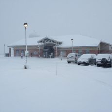
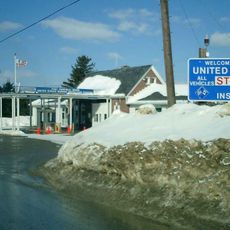
The Saint Leonard-Van Buren Bridge crosses the Saint John River and connects a community in Canada with a town in the United States. The structure has three traffic lanes and border inspection facilities on both ends.

A hand-pulled ferry originally connected the two towns before a bridge was built in 1911. A complete reconstruction in 1972 expanded its capacity to handle growing border traffic.

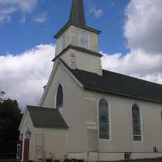
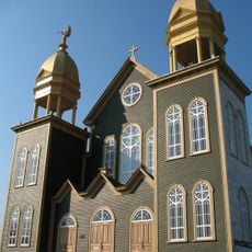
The crossing links two communities with deep Acadian roots, visible in the way locals speak and in traditional building styles throughout both towns. This heritage shapes daily life and draws visitors interested in French-speaking North American culture.

Crossing is straightforward for drivers coming from either side. Check border station hours in advance, especially on weekdays and around holidays, to avoid delays.

The crossing ranks among the busiest border points between the two countries, yet it remains relatively quiet compared to major crossings elsewhere. It serves primarily local and regional traffic rather than drawing large numbers of tourists.

The community of curious travelers

AroundUs brings together thousands of curated places, local tips, and hidden gems, enriched daily by 60,000 contributors worldwide.

Start exploring
Location
Location
Inception
1911
Part of
Canada–United States border
GPS coordinates
47.15970,-67.93090
Latest update
December 14, 2025 14:25
Around this place
Double Eagle II
United States of America

Double Eagle II

59.7 km
Aroostook Valley Country Club
Canada

Aroostook Valley Country Club

41.4 km
Fort Kent
United States of America

Fort Kent

51 km
United States of America

Loring Commerce Centre

24.6 km
Aroostook National Wildlife Refuge
United States of America

Aroostook National Wildlife Refuge

23.8 km
New Brunswick Botanical Garden
Canada

New Brunswick Botanical Garden

47.3 km
Loring Air Force Base Double Cantilever Hangar
United States of America

Loring Air Force Base Double Cantilever Hangar

25.2 km
Loring Air Force Base Arch Hangar
United States of America

Loring Air Force Base Arch Hangar

24.6 km
National Weather Service Caribou, Maine
United States of America

National Weather Service Caribou, Maine

33 km
Fort Fairfield - Andover Border Crossing
Canada

Fort Fairfield - Andover Border Crossing

45.2 km
Mark and Emily Turner Memorial Library
United States of America

Mark and Emily Turner Memorial Library

53.8 km
Acadian Landing Site
United States of America

Acadian Landing Site

33.6 km
Gustaf Adolph Lutheran Church
United States of America

Gustaf Adolph Lutheran Church

28.5 km
Musée Culturel du Mont-Carmel
United States of America

Musée Culturel du Mont-Carmel

18.9 km
Mont Farlagne
Canada

Mont Farlagne

43.9 km
Gray Memorial United Methodist Church and Parsonage
United States of America

Gray Memorial United Methodist Church and Parsonage

34 km
Acadian Village
United States of America

Acadian Village

6.7 km
Branche à Jerry
Canada

Branche à Jerry

60.7 km
Fort Fairfield Public Library
United States of America

Fort Fairfield Public Library

43.8 km
Philo Reed House
United States of America

Philo Reed House

44.5 km
Governor Brann School
United States of America

Governor Brann School

4.8 km
De la République Provincial Park
Canada

De la République Provincial Park

46.7 km
P'tit Sault Blockhouse
Canada

P'tit Sault Blockhouse

37.3 km
Avro Lancaster KB882
Canada

Avro Lancaster KB882

55 km
Cathédrale de l'Immaculée-Conception d'Edmundston
Canada

Cathédrale de l'Immaculée-Conception d'Edmundston

37.9 km
Mont Farlagne
Canada

Mont Farlagne

43.9 km
Isaie and Scholastique Martin House
United States of America

Isaie and Scholastique Martin House

37.6 km
Simon-Larouche Pavilion
Canada

Simon-Larouche Pavilion

37.4 km
Show the full map
Reviews
Share your experience

No review yet

Discussions
Start a discussion...

No discussion yet

« Saint Leonard – Van Buren Bridge - International road bridge between Saint Leonard, New Brunswick and Van Buren, Maine » is provided by Around Us (aroundus.com). Images and texts are derived from Wikimedia project under a Creative Commons license. You are allowed to copy, distribute, and modify copies of this page, under the conditions set by the license, as long as this note is clearly visible.

Discover hidden gems everywhere you go!

From secret cafés to breathtaking viewpoints, skip the crowded tourist spots and find places that match your style. Our app makes it easy with voice search, smart filtering, route optimization, and insider tips from travelers worldwide. Download now for the complete mobile experience.

Around Us App Screenshot

A unique approach to discovering new places

Le Figaro

All the places worth exploring

France Info

A tailor-made excursion in just a few clicks

20 Minutes

Around Us
Travel Guide & Maps
Download

Send to your phone

QR Code
1

Open the camera app on your mobile.

2

Point at the QR code with your camera. A notification will appear.

3

Tap the notification to open the link.