Königsmünster Abbey, Benedictine abbey in Meschede, Germany
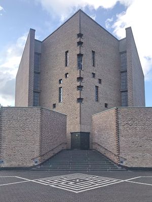
Königsmünster Abbey is a Benedictine monastery on a hilltop in Meschede with a modern central church, workshops, retreat houses, and school buildings. The complex is home to an active community that combines traditional monastic life with craft work and education.
The monastery was founded in 1928 with support from three Bavarian abbeys that helped establish the community. It faced closure during the 1940s but later resumed its operations and growth.
The metalwork workshop here produces religious objects like altars and candlesticks that appear in churches across the region. This craft tradition connects the monks' daily work to their spiritual life.
Visitors can stay in the monastery's accommodations and participate in periods of quiet to experience monastic life firsthand. The abbey shop sells handmade products including chocolate and jewelry created in the onsite workshops.
The monastery belongs to the Congregation of Saint Ottilien, a worldwide monastic order involved in mission work across several continents. This global connection shapes how the community engages with the wider world beyond their hilltop home.
Location: Meschede
Inception: 1928
Architects: Hans Schilling
Address: Klosterberg
Website: https://koenigsmuenster.de
GPS coordinates: 51.35390,8.27917
Latest update: December 8, 2025 19:51
Hennetalsperre
3.9 km
Schloss Laer
1.7 km
St. Walburga, Meschede
941 m
Hünenburg
1.5 km
Fatih-Moschee
260 m
St. Michaels-Kapelle
785 m
Kloster Galiläa
1.2 km
Turmruine Laer
2.3 km
Naturdenkmal Stieleiche südwestlich Enste
2.8 km
Church of the Assumption
302 m
Alte Synagoge
867 m
Pulverturm
213 m
Jewish Cemetery, Meschede
1.4 km
Evangelische Christuskirche (Meschede)
1.1 km
Ruhrmäander bei Laer
2.6 km
Hainberg
1.2 km
Linde südlicher Ortsrand Enste
2.3 km
Kleines Steinmecketal
2.5 km
Drüerberg
2.7 km
Schweinsbruch
1.6 km
Offenland um Enste
2.6 km
Talraum südwestlich Meschede
1.8 km
Ruhrtal südlich Ensthof
2.8 km
Ruhrtalflanke südlich Hardt / Eiserkaulen
1.9 km
Ruhrtal bei Hofanlage Laer
1 km
Ensterbachtal zwischen Enste und Landesstraße 743
2.1 km
Am Kohlweder
2.2 km
Birmecke und Eiserkaulen-Südhang
2.4 kmVisited this place? Tap the stars to rate it and share your experience / photos with the community! Try now! You can cancel it anytime.
Discover hidden gems everywhere you go!
From secret cafés to breathtaking viewpoints, skip the crowded tourist spots and find places that match your style. Our app makes it easy with voice search, smart filtering, route optimization, and insider tips from travelers worldwide. Download now for the complete mobile experience.
A unique approach to discovering new places❞
— Le Figaro
All the places worth exploring❞
— France Info
A tailor-made excursion in just a few clicks❞
— 20 Minutes