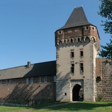
Durnomagus, Roman military fort in Dormagen, Germany
Durnomagus was a Roman military fort in Dormagen covering about three hectares with easy access from the river. The installation contained housing for mounted soldiers, storage buildings, administrative structures, and stables arranged within a fortified rectangular layout.
The fort was established around 85 AD with wooden ramparts, then reinforced with stone walls in later decades. It served as a strategic Roman strongpoint on the Rhine for several centuries until eventually abandoned.
This site served as a key posting for Roman soldiers stationed to guard the Rhine frontier. The remains reveal how the garrison practiced their faith and maintained daily routines in this distant outpost.
The fort's remains are today buried under modern Dormagen, but the city museum displays finds and information about ancient life at this location. Visitors can follow marked routes to explore excavation sites and learn more about the discoveries made here.
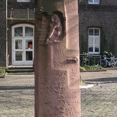
An excavated Mithras shrine on Weingartenstraße contains rare reliefs showing scenes from the worship of this eastern deity. This religious space offers a glimpse into the personal beliefs of soldiers stationed far from home.
Location: Dormagen
Location: Germania Inferior
Part of: Lower German Limes, Frontiers of the Roman Empire – The Lower German Limes (Germany)
GPS coordinates: 51.09250,6.84056
Latest update: December 9, 2025 12:24
Wildpark Tannenbusch
3.8 km
Burg Friedestrom
3.1 km
Marienburg Monheim
3 km
Baumberger Rheinterrassen
3.8 km
Kapelle Raphaelshaus Dormagen
1.7 km
Christuskirche
781 m
Kreismuseum Zons
3.2 km
St. Michael
229 m
St. Katharina
3.6 km
St. Gereon
2.8 km
Marienkapelle
3.1 km
St. Dionysius
4.3 km
St. Martinus
3.2 km
Jewish cemeteries in Monheim am Rhein
4.1 km
Markstein im Kampf der Kölner Bürger um ihre Unabhängigkeit
3.6 km
Rheinaue Zons-Rheinfeld und Altrheinschlinge Zons
3.1 km
Church of Peace (Zons)
3.3 km
Evangelisches Gemeindezentrum Arche (Dormagen-Rheinfeld)
721 m
Holy Trinity Chapel
3.4 km
Landschaftsschutzgebiet Rhein und Rheinauen Worringen bis Merkenich
3.4 km
Matthäuskirche (Dormagen-Delhoven)
4.2 km
Church of Peace
3.4 km
LSG-Urdenbacher Altrhein <Raumeinheit D>
4.5 km
St. Johannes der Täufer (Monheim am Rhein)
4.1 km
Protestant Church
3 km
St. Pankratius (Köln-Worringen)
3.6 km
Hackenbroicher Straße 114
3.2 km
Eki-Haus Evangelische Kirche (Monheim am Rhein)
4 kmVisited this place? Tap the stars to rate it and share your experience / photos with the community! Try now! You can cancel it anytime.
Discover hidden gems everywhere you go!
From secret cafés to breathtaking viewpoints, skip the crowded tourist spots and find places that match your style. Our app makes it easy with voice search, smart filtering, route optimization, and insider tips from travelers worldwide. Download now for the complete mobile experience.
A unique approach to discovering new places❞
— Le Figaro
All the places worth exploring❞
— France Info
A tailor-made excursion in just a few clicks❞
— 20 Minutes