Hainberg, Mountain summit near Göttingen, Germany
Hainberg is a forested mountain near Göttingen standing at 314 meters high, located within the Göttingen Forest area of Lower Saxony. The terrain features multiple marked trails winding through dense woodland with sections that open to views across the surrounding region.
The Hainberg's west slope was largely bare until the late 19th century, when mayor Georg Merkel directed a reforestation programme from 1871 to 1893 to protect Göttingen from flash floods. Before that, the slopes were grazed, and field names such as Molkengrund, Trift and Schäferbrunnen recall that use. On the dry limestone patches called Dreischen only sparse grass and thorn bushes grew.
The names of the Hainberg's meadows and springs record former uses: Molkengrund, Trift and Schäferbrunnen point to dairy farming, drove roads and shepherding. On the Dreischen, thin grass and thorn scrub on stony limestone grew from long, intensive grazing. The Reinsbrunnen in the Molkengrund feeds the Schwanenteich in the Cheltenhampark, and the nearby Kleine Reinsbrunnen has a grotto-like surround with a bronze water-woman sculpture.
Multiple marked trails lead from Göttingen to the summit, with public transportation stops positioned at several access points around the mountain base. The paths are walkable throughout the year, though the ground can be muddy in spring after rain.
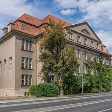
The Wiechert Earthquake Observatory, founded by geophysicist Emil Wiechert, stands on the Hainberg; its instruments recorded ground motion here from the early 20th century. Nearby, the Osterholz-Bank rests where the Herberhäuser Stieg crosses the ridge, and a water reservoir lies at the transition to the Warteberg.
The community of curious travelers
AroundUs brings together thousands of curated places, local tips, and hidden gems, enriched daily by 94,384 contributors worldwide.