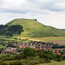
Ohrengipfel, Mountain summit in Baden-Württemberg, Germany.
Ohrengipfel is a mountain peak in Baden-Württemberg with a flat summit area that is easily accessible. The site is located in the Swabian Alb region and is reached by marked hiking trails.
On 5 September 1634, General Gustaf Horn led Swedish troops from Breitwang near Bopfingen over the Ohrengipfel to Hürnheim before the Battle of Nördlingen. Around 1900 the area was still called Karthäuserhau, after the nearby Kartäusertal near Christgarten, and belonged to the Prince of Wallerstein.
The name Ohrengipfel refers to the ear-like shape of the summit. The surrounding area was still called Karthäuserhau at the start of the 20th century, after the nearby Kartäusertal near Christgarten. The Schwäbische Albverein's local Bopfingen group maintains the trail markings on the Schwäbische-Alb-Nordrand-Weg, which has passed just below the summit since 1907.
The Schwäbische-Alb-Nordrand-Weg, laid out in 1907, runs just below the summit and is waymarked by the Bopfingen group of the Swabian Alb Association. Since 2010 the Schwedenweg follows the route of the Swedish army over the Ohrengipfel. The flat, wooded top holds only benches, and the view is limited by beeches.
On 8 July 1900 a 12.70 m iron platform and staircase, weighing 1,070 kg together, was opened on the summit; only six people were allowed on it at once. It was fixed to a beech tree by locksmith Hochmüller of Neresheim, paid for by the Schwäbischer Albverein and the Nördlingen beautification society. Its later fate is unknown; the flat summit now holds only benches.
The community of curious travelers
AroundUs brings together thousands of curated places, local tips, and hidden gems, enriched daily by 94,367 contributors worldwide.