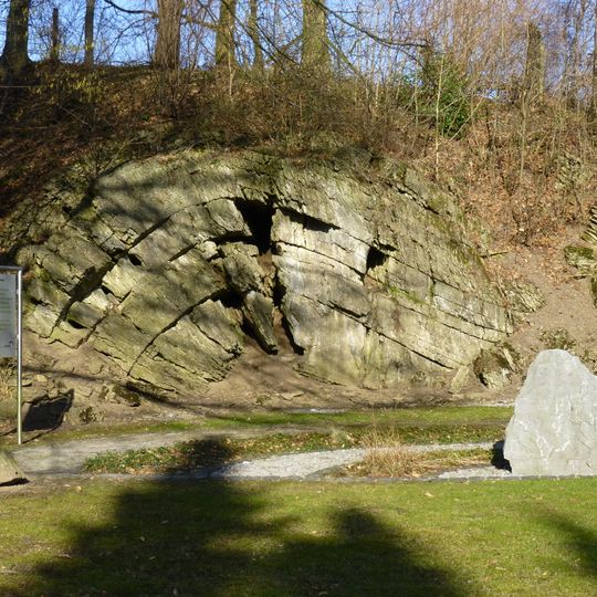
Tillmannsdorfer Sattel, Natural monument and archaeological site in Wülfrath, Germany.
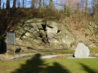
The Tillmannsdorfer Sattel, also called the Tillmannsdorfer Falte, is a protected geological outcrop in the Tillmannsdorf district of Wülfrath, on the city boundary with Wuppertal. It exposes a third-order fold in Carboniferous Kohlenkalk limestone, about 15 metres in wavelength and rising roughly 4 metres above the ground.
During the Devonian period, a shallow sea covered this area with reefs that accumulated limestone deposits. Coral remains and calcareous organisms from that ancient seabed formed the foundation of today's rock layers.
The name comes from the hamlet of Tillmannsdorf, not from a family history. The outcrop lies on the Eulenkopfweg, a marked hiking trail that passes the site, and it is entered in Wülfrath's list of archaeological monuments, so walkers meet it as one stop on a longer route through the Düssel valley.
The Eulenkopfweg long-distance hiking trail passes directly by the outcrop, which lies in the Tillmannsdorf district south of the village of Düssel on the Wuppertal city boundary. The rock face stands about 4 metres above ground, so the folded layers are best viewed from the path itself. No lighting is installed; visit in daylight.
The fold is a third-order structure with a wavelength of about 15 metres, rising roughly 4 metres above the ground. The Eulenkopfweg hiking trail passes directly by the outcrop, which is listed in Wülfrath's register of archaeological monuments.
The community of curious travelers
AroundUs brings together thousands of curated places, local tips, and hidden gems, enriched daily by 94,422 contributors worldwide.