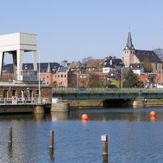
Mintarder Ruhrtalbrücke, Road bridge in Mülheim an der Ruhr, Germany
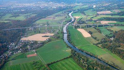
The Mintarder Ruhrtalbrücke is a long steel structure that crosses a valley, stretching roughly 2 kilometers in length. Its deck sits at a significant height above the ground and accommodates four lanes of traffic flowing in both directions.
Construction began in 1963 as part of post-war development in the Ruhr region and was finished in 1966. The bridge was built to connect two major cities along what became the A52 motorway route.
The bridge takes its name from the nearby village and has shaped how locals perceive their landscape. It serves as a landmark that residents and travelers alike recognize as part of the Ruhr region's character.
The bridge is easily visible from various viewpoints in the area and offers a good perspective when crossing it or viewing from below. The best time to see it clearly is during daylight hours when the structure and landscape below are well lit.
The bridge uses a hollow box design that gives it exceptional strength, with a gentle slope built in to direct water away. This clever engineering detail is rarely noticed by passing drivers, yet it has allowed the structure to safely carry hundreds of thousands of vehicles year after year.
The community of curious travelers
AroundUs brings together thousands of curated places, local tips, and hidden gems, enriched daily by 60,000 contributors worldwide.