Rangierbahnhof Wedau
Rangierbahnhof Wedau, Classification yard and architectural heritage monument in Duisburg, Germany
Rangierbahnhof Wedau is a classification yard in Duisburg that sorts freight trains using two sorting hills and multiple parallel tracks. The facility includes buildings and track arrangements designed to organize and reorganize train compositions for efficient transport.
The yard was built in 1890 on swampy ground and expanded into one of Germany's largest classification facilities by 1913. Its growth was central to Duisburg's development as a major transport hub.
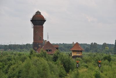
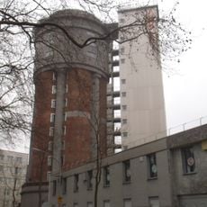
The preserved signal box and brick water tower from 1912 show how the region developed its railway operations. These structures reflect the way industrial heritage remains visible in the buildings and layout of the yard.
The site remains in active operation for freight transport, so visitors should follow safety guidelines and stay in permitted areas only. It is advisable to check in advance about any access restrictions or organized visits to the location.
The yard sits between repair shops and worker housing, forming part of the Route of Industrial Culture network. This arrangement reveals how factory operations and residential areas were intertwined in the industrial city.
Location: Duisburg
GPS coordinates: 51.39210,6.80513
Latest update: December 14, 2025 16:47
Wedaustadion
2.6 km
Haus Hartenfels
3.7 km
Christoph 9
1.8 km
Duisburger Stadtwald
3.4 km
Waldfriedhof Duisburg
2.6 km
Villa Fritz Thyssen
1.9 km
Expo-Brücke
3.9 km
Haus Küchen
2.4 km
Fraunhofer Institute for Microelectronic Circuits and Systems
4.1 km
Wasserturm Hochfeld
3.7 km
Haus Remberg
4.2 km
Biegerpark
4 km
Church of St Jude Thaddeus
3.1 km
Masurensee
668 m
St. Gabriel
3.5 km
Haubachsee
2 km
Jüdischer Friedhof
3.3 km
Wambachtal und Oembergmoor
2.6 km
Neuer jüdischer Friedhof
2.6 km
Hangquellen an der Tannenstraße
1.2 km
Aussichtsturm Wolfsberg
1.6 km
Aue des Alten Angerbaches am Altenbrucher Damm
3.6 km
Christuskirche Mülheim-Saarn
3.8 km
LSG-Nachtigallentat und Scheuerbachtal
3.6 km
Landschaftsschutzgebiet Duisburger Stadtwald mit den Bereichen Witzberg, Monning, Wolfsberg, Am Stein, Eselsbruch, Nachtigallental, Uhlenhorst
3.3 km
Koloniestraße 72
3.9 km
LSG Naherholungsgebiet Entenfang
2 km
St. Joseph's Church
822 mVisited this place? Tap the stars to rate it and share your experience / photos with the community! Try now! You can cancel it anytime.
Discover hidden gems everywhere you go!
From secret cafés to breathtaking viewpoints, skip the crowded tourist spots and find places that match your style. Our app makes it easy with voice search, smart filtering, route optimization, and insider tips from travelers worldwide. Download now for the complete mobile experience.
A unique approach to discovering new places❞
— Le Figaro
All the places worth exploring❞
— France Info
A tailor-made excursion in just a few clicks❞
— 20 Minutes