Enable Location

We need your location to show you interesting places around you

Discover nearby places

Find interesting locations and hidden gems around you

Precise directions

Get accurate directions and distances to places

Your location is never shared with other users. It's only used when you tap the location button.

Ruhrbrücke Bochumer Straße

Log in to your account

Start exploring — it's free

Trusted by 62,371 travelers worldwide

Continue with Google
Continue with Apple
or

We will send you a code to connect

By continuing, you accept our Terms and Conditions and our Privacy Policy

Check your inbox

We've sent a pincode in your inbox. Please enter the code below.

Ruhrbrücke Bochumer Straße

Ruhrbrücke Bochumer Straße, pont allemand

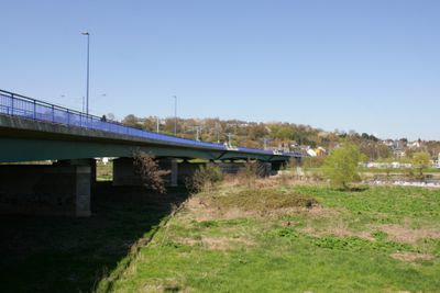
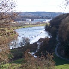
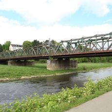
The Ruhrbrücke Bochumer Straße is a road bridge in Hattingen that crosses the Ruhr River and connects the city center with the Winz-Baak neighborhood. It carries car traffic, streetcars, and buses in two parallel sections shaped as smooth arches made from concrete and steel.

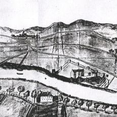
The first bridge at this location was built in 1319 with eight arches and four defensive towers, serving medieval trade and travel. The current structure dates from 1998 to 2002 and replaced several older bridges that required rebuilding due to damage from war, the Thirty Years War, and general wear over the centuries.

The bridge was a favorite subject for postcards and artwork over many decades, capturing daily life in Hattingen. Visitors could see streetcars and local activity in historical images, making the structure a visual symbol of the town's identity.

The bridge is accessible to pedestrians, cyclists, and vehicles with wide lanes for smooth traffic flow. The area is quiet and friendly, making it good for walks with views of the river and surrounding buildings.

The bridge was destroyed in 1945 during the final days of World War II to prevent enemy use and had to be completely rebuilt afterward. This episode shows how vital the structure was to the town's connection and how determined people were to restore it.

The community of curious travelers

AroundUs brings together thousands of curated places, local tips, and hidden gems, enriched daily by 60,000 contributors worldwide.

Start exploring
Location
Inception
June 2002
GPS coordinates
51.40542,7.16892
Latest update
February 9, 2026 11:07
« Ruhrbrücke Bochumer Straße - pont allemand » is provided by Around Us (aroundus.com). Images and texts are derived from Wikimedia project under a Creative Commons license. You are allowed to copy, distribute, and modify copies of this page, under the conditions set by the license, as long as this note is clearly visible.

Discover hidden gems everywhere you go!

From secret cafés to breathtaking viewpoints, skip the crowded tourist spots and find places that match your style. Our app makes it easy with voice search, smart filtering, route optimization, and insider tips from travelers worldwide. Download now for the complete mobile experience.

Around Us App Screenshot

A unique approach to discovering new places

Le Figaro

All the places worth exploring

France Info

A tailor-made excursion in just a few clicks

20 Minutes

Around Us
Travel Guide & Maps
Download

Send to your phone

QR Code
1

Open the camera app on your mobile.

2

Point at the QR code with your camera. A notification will appear.

3

Tap the notification to open the link.