Morne du Vitet, Mountain summit in Saint Barthélemy, France.
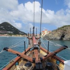
Morne du Vitet is the highest point of Saint Barthélemy, a broad mass of dark green vegetation whose uneven top forms two rounded peaks joined by a dipping ridge. Its slopes descend to a steep cliff of layered brownish-gray rock that drops to the sea, with scattered small structures on the lower slopes and along the cliff edge.
The sources record no historical events, dates or figures for Morne de Vitet. Its name comes from the old French colonial term "morne", given to a small mountain, still used in Saint-Pierre-et-Miquelon. The mountain's documented record is geographic: at 284–286 m it is the highest point of Saint Barthélemy, in the Vitet quarter on the windward eastern side of the island.
The name comes from the Vitet quarter on the island's windward eastern side, where the mountain stands; in old French colonial usage a "morne" is a small mountain, a term also found in Saint-Pierre-et-Miquelon. The gentler eastern and northern slopes are settled, so houses and gardens reach partway up the mountain, while the steeper western and southern flanks remain unbuilt.
The climb takes roughly 1 to 2 hours depending on your fitness level and starting point along the marked trail. It is best to start early in the morning to catch the sunrise and avoid the daytime heat.
The south face drops from the 286-metre summit to the sea within 400 metres, the steepest fall on Saint Barthélemy. Because of this, the south and west slopes carry no buildings, while houses line the gentler east and north sides. From offshore, the cliff of layered brownish-gray rock at the base of the slope is visible below the green upper mass.
The community of curious travelers
AroundUs brings together thousands of curated places, local tips, and hidden gems, enriched daily by 93,358 contributors worldwide.