Enable Location

We need your location to show you interesting places around you

Discover nearby places

Find interesting locations and hidden gems around you

Precise directions

Get accurate directions and distances to places

Your location is never shared with other users. It's only used when you tap the location button.

Lac de Saint-Étienne-Cantalès

Log in to your account

Start exploring — it's free

Trusted by 63,932 travelers worldwide

Continue with Google
Continue with Apple
or

We will send you a code to connect

By continuing, you accept our Terms and Conditions and our Privacy Policy

Check your inbox

We've sent a pincode in your inbox. Please enter the code below.

Lac de Saint-Étienne-Cantalès
Discussion Reviews 1 Photos 1 Collections
5.3k Popularity

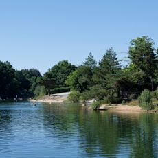
Lac de Saint-Étienne-Cantalès, Artificial reservoir in Saint-Étienne-Cantalès, France.

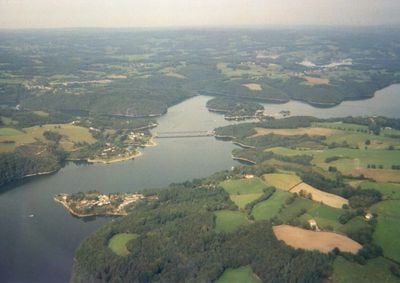
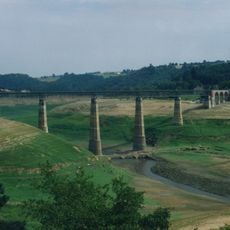
Lac de Saint-Étienne-Cantalès is an artificial reservoir covering roughly 560 hectares across several communes in Cantal, created by damming the old Cère valley. The water stretches about 13 kilometers, with a distinctive arch dam rising prominently above the surface.

Construction of the arch dam was completed in 1945, reaching about 69 meters high and fundamentally reshaping the regional landscape. The structure powers a hydroelectric station that continues to supply energy to the area.

Fishing has long connected people to this lake, with locals and visitors casting lines for carp, pike, and bass throughout the year. The sight of anglers along the shore reflects how much this water means to the surrounding communities.

Three supervised swimming areas operate during summer at Puech des Ouilhes, Rénac, and Espinet, each with parking and easy water access. Several boat launch sites are spread around the perimeter for those wanting to venture onto the water.

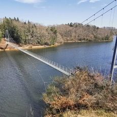
A 124-meter footbridge built in Himalayan style spans the water between the beaches of Espinet and Rénac. This striking bridge offers visitors a memorable way to cross between the two swimming areas and scenic lake views from above.

The community of curious travelers

AroundUs brings together thousands of curated places, local tips, and hidden gems, enriched daily by 60,000 contributors worldwide.

Start exploring
Location
Location
Location
Saint-Mamet-la-Salvetat
Location
Address
Lac de Saint-Étienne-Cantalès, France
GPS coordinates
44.92000,2.25000
Latest update
December 6, 2025 17:41
Lakes of Auvergne-Rhône-Alpes: volcanic craters, glacier waters, mountain dams

The Auvergne-Rhône-Alpes area has lakes from very different beginnings. Large lakes that formed from glaciers, like Lake Bourget or Lake Annecy, appeared after the glaciers in the Alps melted. They have deep water surrounded by mountains. In the Massif Central, volcanic lakes sit in old craters,...

Reviews
Share your experience

No review yet

Discussions
Start a discussion...

No discussion yet

« Lac de Saint-Étienne-Cantalès - Artificial reservoir in Saint-Étienne-Cantalès, France » is provided by Around Us (aroundus.com). Images and texts are derived from Wikimedia project under a Creative Commons license. You are allowed to copy, distribute, and modify copies of this page, under the conditions set by the license, as long as this note is clearly visible.

Discover hidden gems everywhere you go!

From secret cafés to breathtaking viewpoints, skip the crowded tourist spots and find places that match your style. Our app makes it easy with voice search, smart filtering, route optimization, and insider tips from travelers worldwide. Download now for the complete mobile experience.

Around Us App Screenshot

A unique approach to discovering new places

Le Figaro

All the places worth exploring

France Info

A tailor-made excursion in just a few clicks

20 Minutes

Around Us
Travel Guide & Maps
Download

Send to your phone

QR Code
1

Open the camera app on your mobile.

2

Point at the QR code with your camera. A notification will appear.

3

Tap the notification to open the link.